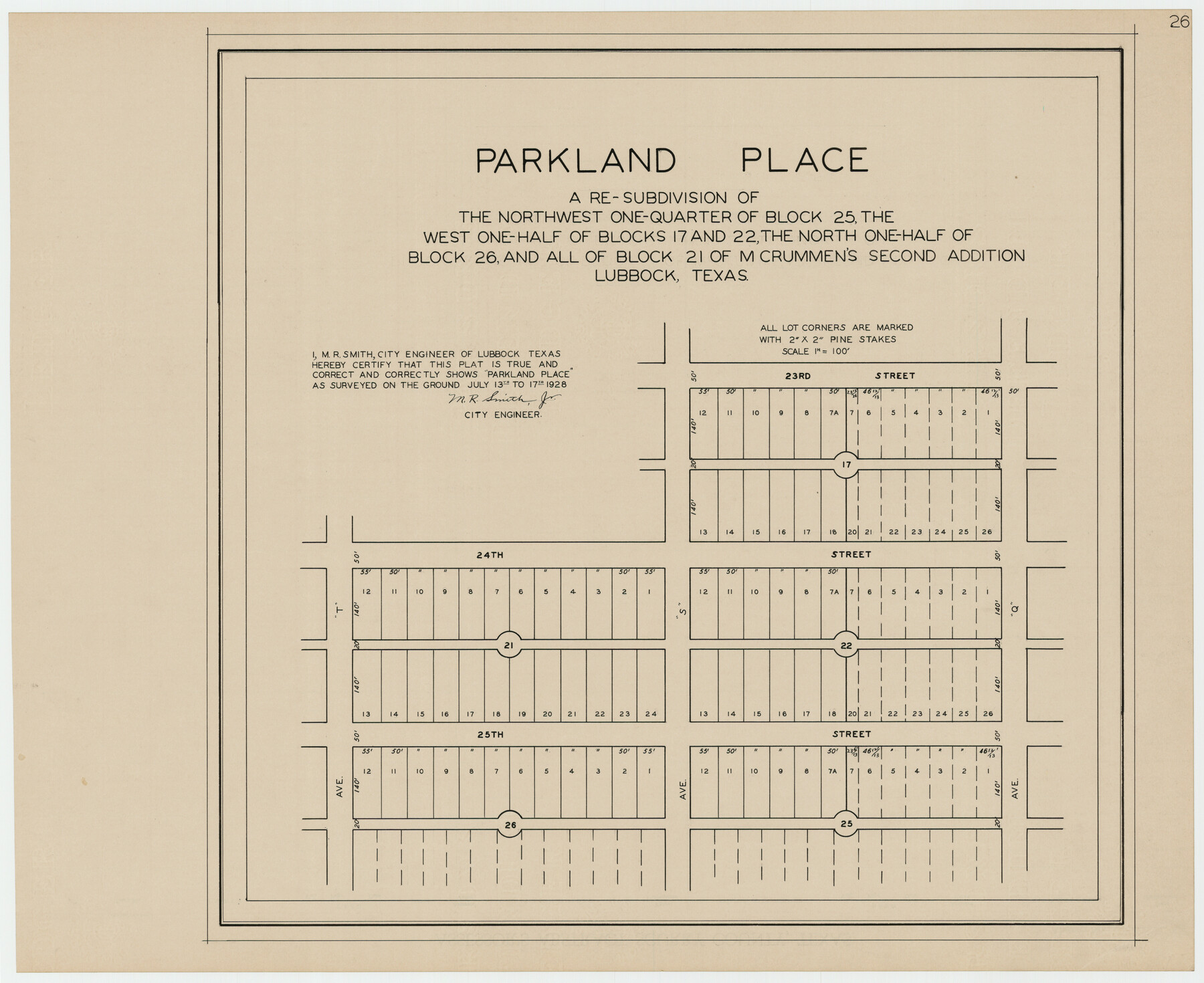
Parkland Place
-
Map/Doc
92278
-
Collection
Twichell Survey Records
-
Object Dates
7/13/1928 (Creation Date)
-
People and Organizations
M.R. Smith Jr. (Surveyor/Engineer)
-
Counties
Lubbock
-
Height x Width
15.9 x 13.0 inches
40.4 x 33.0 cm
Part of: Twichell Survey Records
[Sketch showing west part of county]
![91712, [Sketch showing west part of county], Twichell Survey Records](https://historictexasmaps.com/wmedia_w700/maps/91712-1.tif.jpg)
Print $3.00
- Digital $50.00
[Sketch showing west part of county]
1907
Size 16.4 x 11.1 inches
Map/Doc 91712
Hill Ranch, Gaines County, Texas

Print $20.00
- Digital $50.00
Hill Ranch, Gaines County, Texas
1951
Size 21.2 x 16.6 inches
Map/Doc 92680
Working Sketch in Bastrop County

Print $20.00
- Digital $50.00
Working Sketch in Bastrop County
1921
Size 14.0 x 15.8 inches
Map/Doc 90232
[Township 3 North, Blocks 31 and 32]
![91213, [Township 3 North, Blocks 31 and 32], Twichell Survey Records](https://historictexasmaps.com/wmedia_w700/maps/91213-1.tif.jpg)
Print $3.00
- Digital $50.00
[Township 3 North, Blocks 31 and 32]
Size 12.5 x 10.8 inches
Map/Doc 91213
Map No. 1 - Surveys Located in 1881 as they appear on the ground

Print $20.00
- Digital $50.00
Map No. 1 - Surveys Located in 1881 as they appear on the ground
1881
Size 30.9 x 19.6 inches
Map/Doc 91927
John N. Jane's Subdivision of Sterling County School Lands Lamb County, Texas

Print $20.00
- Digital $50.00
John N. Jane's Subdivision of Sterling County School Lands Lamb County, Texas
Size 19.9 x 23.0 inches
Map/Doc 92179
[Blocks G and H, and vicinity]
![92671, [Blocks G and H, and vicinity], Twichell Survey Records](https://historictexasmaps.com/wmedia_w700/maps/92671-1.tif.jpg)
Print $20.00
- Digital $50.00
[Blocks G and H, and vicinity]
1915
Size 18.4 x 12.4 inches
Map/Doc 92671
Plat Showing Survey made for J. M. Teague, Jr. Gaines County, Texas

Print $20.00
- Digital $50.00
Plat Showing Survey made for J. M. Teague, Jr. Gaines County, Texas
1956
Size 12.7 x 18.7 inches
Map/Doc 92672
N. F. Cleavinger

Print $3.00
- Digital $50.00
N. F. Cleavinger
Size 16.5 x 10.6 inches
Map/Doc 92406

[Additions Surrounding Fort Worth & Denver Railroad Fork]
![92840, [Additions Surrounding Fort Worth & Denver Railroad Fork], Twichell Survey Records](https://historictexasmaps.com/wmedia_w700/maps/92840-1.tif.jpg)
Print $20.00
- Digital $50.00
[Additions Surrounding Fort Worth & Denver Railroad Fork]
Size 32.2 x 32.1 inches
Map/Doc 92840
[Sketch showing Block M-20, Sections 9 through 46 and Block 22, Sections 1 through 12]
![91717, [Sketch showing Block M-20, Sections 9 through 46 and Block 22, Sections 1 through 12], Twichell Survey Records](https://historictexasmaps.com/wmedia_w700/maps/91717-1.tif.jpg)
Print $3.00
- Digital $50.00
[Sketch showing Block M-20, Sections 9 through 46 and Block 22, Sections 1 through 12]
Size 10.9 x 13.9 inches
Map/Doc 91717
You may also like
Floyd County Sketch File 20

Print $4.00
- Digital $50.00
Floyd County Sketch File 20
1914
Size 14.5 x 8.9 inches
Map/Doc 22772
Representation of surveys on the waters of the Paluxy and Bosque in the crosstimbers in Milam District

Print $2.00
- Digital $50.00
Representation of surveys on the waters of the Paluxy and Bosque in the crosstimbers in Milam District
1847
Size 13.9 x 8.0 inches
Map/Doc 258
Flight Mission No. CRC-3R, Frame 15, Chambers County

Print $20.00
- Digital $50.00
Flight Mission No. CRC-3R, Frame 15, Chambers County
1956
Size 18.5 x 22.2 inches
Map/Doc 84789
Bastrop County, From McDade to Austin, Texas, Houston & Texas Central Railroad

Print $20.00
- Digital $50.00
Bastrop County, From McDade to Austin, Texas, Houston & Texas Central Railroad
1939
Size 26.6 x 15.5 inches
Map/Doc 64364
The Republic County of San Patricio. December 29, 1845

Print $20.00
The Republic County of San Patricio. December 29, 1845
2020
Size 22.2 x 21.7 inches
Map/Doc 96278
Webb County Sketch File 18

Print $20.00
- Digital $50.00
Webb County Sketch File 18
1886
Size 19.9 x 17.7 inches
Map/Doc 12637
[Aransas Bay]
![72971, [Aransas Bay], General Map Collection](https://historictexasmaps.com/wmedia_w700/maps/72971.tif.jpg)
Print $20.00
- Digital $50.00
[Aransas Bay]
1846
Size 18.2 x 24.7 inches
Map/Doc 72971
Flight Mission No. CRC-3R, Frame 32, Chambers County

Print $20.00
- Digital $50.00
Flight Mission No. CRC-3R, Frame 32, Chambers County
1956
Size 18.6 x 22.3 inches
Map/Doc 84805
Aransas County Rolled Sketch 15C

Print $3.00
- Digital $50.00
Aransas County Rolled Sketch 15C
Size 10.2 x 17.6 inches
Map/Doc 76067
[H. & T. C. Block 47, Block 1PD, and Vicinity]
![91435, [H. & T. C. Block 47, Block 1PD, and Vicinity], Twichell Survey Records](https://historictexasmaps.com/wmedia_w700/maps/91435-1.tif.jpg)
Print $20.00
- Digital $50.00
[H. & T. C. Block 47, Block 1PD, and Vicinity]
1912
Size 31.8 x 33.5 inches
Map/Doc 91435
Runnels County Working Sketch 10

Print $20.00
- Digital $50.00
Runnels County Working Sketch 10
1948
Size 42.0 x 39.8 inches
Map/Doc 63606
Hood County Sketch File 28

Print $84.00
- Digital $50.00
Hood County Sketch File 28
1880
Size 11.6 x 9.0 inches
Map/Doc 26631