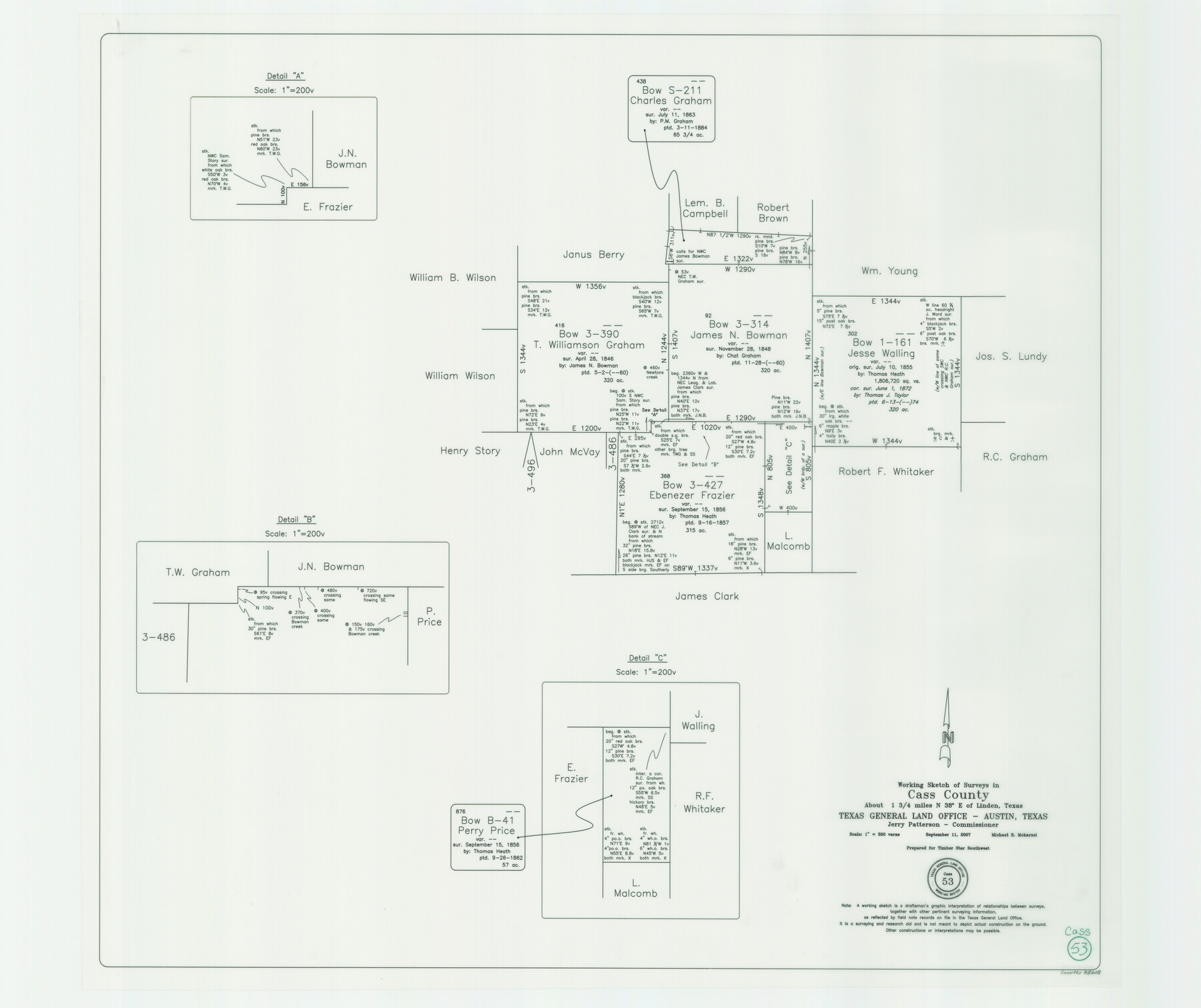
Cass County Working Sketch 53
-
Map/Doc
88608
-
Collection
General Map Collection
-
Object Dates
9/11/2007 (Creation Date)
-
People and Organizations
Michael R. Mokarzel (Draftsman)
Jerry E. Patterson (GLO Commissioner)
-
Counties
Cass
-
Subjects
Surveying Working Sketch
-
Height x Width
30.2 x 36.0 inches
76.7 x 91.4 cm
-
Scale
1" = 300 varas
-
Comments
Survey covers the following files: Bow 3 - 390, Bow 3 - 314, Bow 1 - 161, Bow 3 - 427, Bow B - 41 and Bow S - 211.
Survey located about one and three quarters mile North 38 degrees East of Linden, Texas.
Part of: General Map Collection
Port Aransas-Corpus Christi Waterway, Texas, Avery Point Turning Basin to Vicinity of Tule Lake - Dredging

Print $20.00
- Digital $50.00
Port Aransas-Corpus Christi Waterway, Texas, Avery Point Turning Basin to Vicinity of Tule Lake - Dredging
1947
Size 28.6 x 41.8 inches
Map/Doc 1996
Pecos County Rolled Sketch 127

Print $20.00
- Digital $50.00
Pecos County Rolled Sketch 127
Size 20.7 x 23.9 inches
Map/Doc 7267
Donley County Boundary File 4

Print $10.00
- Digital $50.00
Donley County Boundary File 4
Size 5.7 x 8.4 inches
Map/Doc 52630
Edwards County Working Sketch 104

Print $20.00
- Digital $50.00
Edwards County Working Sketch 104
1972
Size 14.2 x 25.5 inches
Map/Doc 68980
Tyler County Working Sketch 9

Print $20.00
- Digital $50.00
Tyler County Working Sketch 9
1937
Size 25.7 x 27.1 inches
Map/Doc 69479
Wilbarger County Working Sketch 8

Print $20.00
- Digital $50.00
Wilbarger County Working Sketch 8
1948
Size 31.8 x 38.2 inches
Map/Doc 72546
Titus County Sketch File 7

Print $4.00
- Digital $50.00
Titus County Sketch File 7
1853
Size 10.0 x 8.2 inches
Map/Doc 38142
Stonewall County Sketch File 8

Print $14.00
- Digital $50.00
Stonewall County Sketch File 8
1896
Size 8.7 x 7.7 inches
Map/Doc 37222
Martin County

Print $20.00
- Digital $50.00
Martin County
1933
Size 38.9 x 34.0 inches
Map/Doc 77366
Blanco County Sketch File 21a

Print $4.00
- Digital $50.00
Blanco County Sketch File 21a
Size 8.3 x 12.0 inches
Map/Doc 14602
Harris County Boundary File 39 (19)

Print $4.00
- Digital $50.00
Harris County Boundary File 39 (19)
Size 12.6 x 7.9 inches
Map/Doc 54361
Hutchinson County Working Sketch 2

Print $20.00
- Digital $50.00
Hutchinson County Working Sketch 2
Size 32.0 x 18.9 inches
Map/Doc 66360
You may also like
Presidio County Rolled Sketch 50

Print $20.00
- Digital $50.00
Presidio County Rolled Sketch 50
Size 21.2 x 18.4 inches
Map/Doc 7344
Northern Part of Laguna Madre

Print $20.00
- Digital $50.00
Northern Part of Laguna Madre
1965
Size 44.5 x 35.0 inches
Map/Doc 73526
Crockett County Rolled Sketch 52

Print $20.00
- Digital $50.00
Crockett County Rolled Sketch 52
Size 36.7 x 44.7 inches
Map/Doc 8715
[D. & P. Blk. G6 in SE Armstrong and SW Donley Counties]
![90269, [D. & P. Blk. G6 in SE Armstrong and SW Donley Counties], Twichell Survey Records](https://historictexasmaps.com/wmedia_w700/maps/90269-1.tif.jpg)
Print $3.00
- Digital $50.00
[D. & P. Blk. G6 in SE Armstrong and SW Donley Counties]
Size 11.7 x 9.4 inches
Map/Doc 90269
Knox County Sketch File 23

Print $20.00
- Digital $50.00
Knox County Sketch File 23
1931
Size 21.4 x 15.3 inches
Map/Doc 11963
Map of Freeport, Brazoria County, Texas

Print $20.00
- Digital $50.00
Map of Freeport, Brazoria County, Texas
Size 27.0 x 39.1 inches
Map/Doc 7689
[Galveston, Harrisburg & San Antonio Railroad from Cuero to Stockdale]
![64191, [Galveston, Harrisburg & San Antonio Railroad from Cuero to Stockdale], General Map Collection](https://historictexasmaps.com/wmedia_w700/maps/64191.tif.jpg)
Print $20.00
- Digital $50.00
[Galveston, Harrisburg & San Antonio Railroad from Cuero to Stockdale]
1907
Size 14.2 x 34.2 inches
Map/Doc 64191
Schleicher County Rolled Sketch 27

Print $20.00
- Digital $50.00
Schleicher County Rolled Sketch 27
Size 37.4 x 43.3 inches
Map/Doc 9909
Crockett County Sketch File 42

Print $28.00
- Digital $50.00
Crockett County Sketch File 42
Size 12.8 x 8.4 inches
Map/Doc 19755
Garza County Sketch File 32

Print $28.00
- Digital $50.00
Garza County Sketch File 32
1932
Size 8.9 x 14.3 inches
Map/Doc 24109
Orange County Sketch File 16a

Print $11.00
- Digital $50.00
Orange County Sketch File 16a
1891
Size 11.9 x 12.9 inches
Map/Doc 33332
Hood County Working Sketch 10

Print $20.00
- Digital $50.00
Hood County Working Sketch 10
1974
Size 26.7 x 35.6 inches
Map/Doc 66204