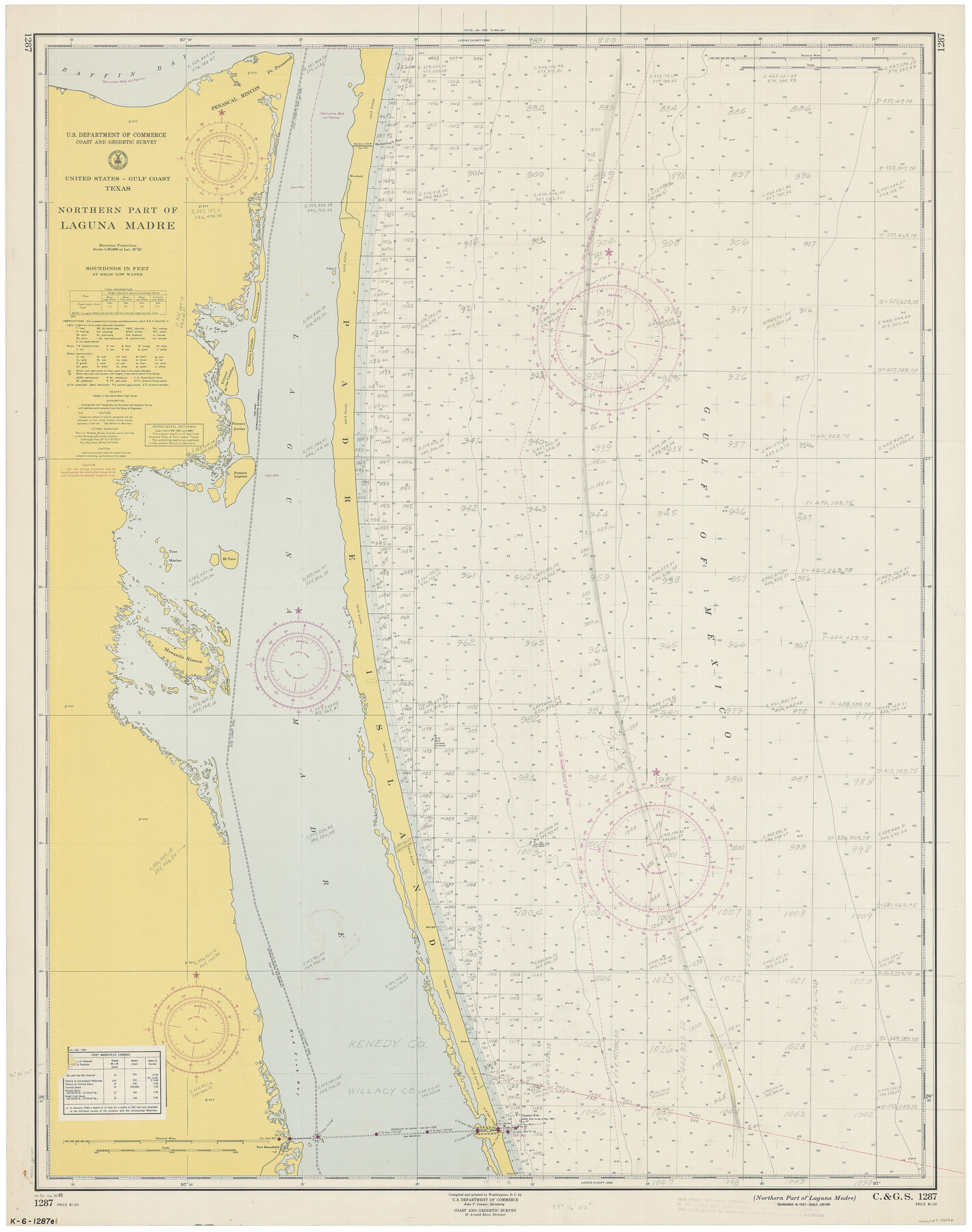
Northern Part of Laguna Madre
K-6-1287a
-
Map/Doc
73526
-
Collection
General Map Collection
-
Object Dates
9/20/1965 (Creation Date)
-
Counties
Kenedy Willacy
-
Subjects
Nautical Charts
-
Height x Width
44.5 x 35.0 inches
113.0 x 88.9 cm
Part of: General Map Collection
Matagorda County Working Sketch 31

Print $20.00
- Digital $50.00
Matagorda County Working Sketch 31
1982
Size 17.2 x 46.9 inches
Map/Doc 70889
Field Notes of Mercer's Colony, Robertson, Nac[a]gdoches, Fannin, & Lamar Counties.
![1953, Field Notes of Mercer's Colony, Robertson, Nac[a]gdoches, Fannin, & Lamar Counties., General Map Collection](https://historictexasmaps.com/wmedia_w700/pdf_converted_jpg/qi_pdf_thumbnail_897.jpg)
Print $30.00
- Digital $50.00
Field Notes of Mercer's Colony, Robertson, Nac[a]gdoches, Fannin, & Lamar Counties.
1845
Size 9.5 x 14.8 inches
Map/Doc 1953
Hutchinson County Sketch File 29

Print $20.00
- Digital $50.00
Hutchinson County Sketch File 29
Size 16.7 x 20.8 inches
Map/Doc 11818
Flight Mission No. DQN-2K, Frame 122, Calhoun County

Print $4.00
- Digital $50.00
Flight Mission No. DQN-2K, Frame 122, Calhoun County
1953
Size 18.5 x 22.2 inches
Map/Doc 84298
Hutchinson County Working Sketch 42

Print $20.00
- Digital $50.00
Hutchinson County Working Sketch 42
1978
Size 27.3 x 23.2 inches
Map/Doc 66402
Sutton County Working Sketch 32

Print $20.00
- Digital $50.00
Sutton County Working Sketch 32
1933
Size 20.5 x 28.3 inches
Map/Doc 62375
Flight Mission No. DQN-1K, Frame 129, Calhoun County

Print $20.00
- Digital $50.00
Flight Mission No. DQN-1K, Frame 129, Calhoun County
1953
Size 18.5 x 22.2 inches
Map/Doc 84192
Flight Mission No. DQN-1K, Frame 142, Calhoun County

Print $20.00
- Digital $50.00
Flight Mission No. DQN-1K, Frame 142, Calhoun County
1953
Size 18.8 x 22.3 inches
Map/Doc 84205
Nueces County Sketch File 13

Print $20.00
- Digital $50.00
Nueces County Sketch File 13
1940
Size 18.3 x 18.7 inches
Map/Doc 42178
Flight Mission No. CUG-1P, Frame 81, Kleberg County

Print $20.00
- Digital $50.00
Flight Mission No. CUG-1P, Frame 81, Kleberg County
1956
Size 18.5 x 22.2 inches
Map/Doc 86146
Pecos County Sketch File 96

Print $40.00
- Digital $50.00
Pecos County Sketch File 96
1957
Size 22.4 x 8.7 inches
Map/Doc 33998
Brazos County Working Sketch 2

Print $20.00
- Digital $50.00
Brazos County Working Sketch 2
1950
Size 31.9 x 36.0 inches
Map/Doc 67477
You may also like
Blanco County Sketch File 39

Print $4.00
- Digital $50.00
Blanco County Sketch File 39
Size 8.6 x 13.9 inches
Map/Doc 14650
[Brooks & Burleson Blocks 2 and 4, Capitol Leagues and other surveys and Blocks in vicinity]
![90645, [Brooks & Burleson Blocks 2 and 4, Capitol Leagues and other surveys and Blocks in vicinity], Twichell Survey Records](https://historictexasmaps.com/wmedia_w700/maps/90645-1.tif.jpg)
Print $20.00
- Digital $50.00
[Brooks & Burleson Blocks 2 and 4, Capitol Leagues and other surveys and Blocks in vicinity]
1903
Size 22.6 x 35.6 inches
Map/Doc 90645
Dimmit County Sketch File 35

Print $6.00
- Digital $50.00
Dimmit County Sketch File 35
1885
Size 6.5 x 8.5 inches
Map/Doc 21155
Runnels County Sketch File 23

Print $20.00
Runnels County Sketch File 23
1924
Size 21.2 x 19.9 inches
Map/Doc 12257
Baylor County Boundary File 16

Print $2.00
- Digital $50.00
Baylor County Boundary File 16
Size 11.2 x 8.7 inches
Map/Doc 50433
[Block XR, Capitol Leagues 161, 162, 164, 174, 178, 179, and 180]
![90729, [Block XR, Capitol Leagues 161, 162, 164, 174, 178, 179, and 180], Twichell Survey Records](https://historictexasmaps.com/wmedia_w700/maps/90729-1.tif.jpg)
Print $20.00
- Digital $50.00
[Block XR, Capitol Leagues 161, 162, 164, 174, 178, 179, and 180]
1908
Size 13.1 x 21.6 inches
Map/Doc 90729
General Highway Map, Fort Bend County, Texas

Print $20.00
General Highway Map, Fort Bend County, Texas
1961
Size 18.1 x 24.5 inches
Map/Doc 79469
Dimmit County Working Sketch 16

Print $20.00
- Digital $50.00
Dimmit County Working Sketch 16
1943
Size 25.6 x 24.8 inches
Map/Doc 68677
[Plat showing connecting lines for the purpose of locating 4.3 acres in Caldwell County]
![90220, [Plat showing connecting lines for the purpose of locating 4.3 acres in Caldwell County], Twichell Survey Records](https://historictexasmaps.com/wmedia_w700/maps/90220-1.tif.jpg)
Print $2.00
- Digital $50.00
[Plat showing connecting lines for the purpose of locating 4.3 acres in Caldwell County]
1923
Size 7.4 x 10.2 inches
Map/Doc 90220
Copy of Surveyor's Field Book, Morris Browning - In Blocks 7, 5 & 4, I&GNRRCo., Hutchinson and Carson Counties, Texas

Print $2.00
- Digital $50.00
Copy of Surveyor's Field Book, Morris Browning - In Blocks 7, 5 & 4, I&GNRRCo., Hutchinson and Carson Counties, Texas
1888
Size 6.9 x 8.8 inches
Map/Doc 62262
Pecos County Sketch File 105

Print $4.00
- Digital $50.00
Pecos County Sketch File 105
1965
Size 14.3 x 8.8 inches
Map/Doc 34028
[Lgs. 209-212, 182, 183, 195-200 with notes]
![90159, [Lgs. 209-212, 182, 183, 195-200 with notes], Twichell Survey Records](https://historictexasmaps.com/wmedia_w700/maps/90159-1.tif.jpg)
Print $20.00
- Digital $50.00
[Lgs. 209-212, 182, 183, 195-200 with notes]
Size 18.7 x 15.6 inches
Map/Doc 90159