Blanco County Sketch File 39
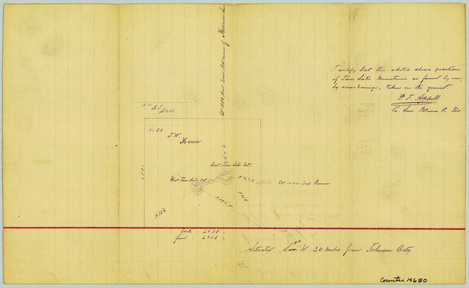
[Sketch showing position of Twin Sister Mountains within J.W. Merwin survey no. 36]
-
Map/Doc
14650
-
Collection
General Map Collection
-
Object Dates
1890/6/2 (File Date)
-
People and Organizations
P.F. Appell (Surveyor/Engineer)
-
Counties
Blanco Kendall
-
Subjects
Surveying Sketch File
-
Height x Width
8.6 x 13.9 inches
21.8 x 35.3 cm
-
Medium
paper, manuscript
-
Features
West Twin Sister Mountain
East Twin Sister Mountain
Part of: General Map Collection
Houston County Working Sketch 38

Print $20.00
- Digital $50.00
Houston County Working Sketch 38
2008
Size 37.8 x 36.2 inches
Map/Doc 88813
Flight Mission No. BRA-7M, Frame 18, Jefferson County

Print $20.00
- Digital $50.00
Flight Mission No. BRA-7M, Frame 18, Jefferson County
1953
Size 18.5 x 22.3 inches
Map/Doc 85469
Travis County Rolled Sketch 43

Print $20.00
- Digital $50.00
Travis County Rolled Sketch 43
1962
Size 27.3 x 22.7 inches
Map/Doc 8041

Township No. 1 South Range No. 24 West of the Indian Meridian

Print $20.00
- Digital $50.00
Township No. 1 South Range No. 24 West of the Indian Meridian
1875
Size 19.2 x 24.4 inches
Map/Doc 75173
DeWitt County Working Sketch 7

Print $20.00
- Digital $50.00
DeWitt County Working Sketch 7
1977
Size 19.0 x 21.2 inches
Map/Doc 68597
Llano County Working Sketch 7

Print $20.00
- Digital $50.00
Llano County Working Sketch 7
1968
Size 30.9 x 30.3 inches
Map/Doc 70625
Harris County Boundary File 39 (22)

Print $40.00
- Digital $50.00
Harris County Boundary File 39 (22)
Size 12.6 x 16.1 inches
Map/Doc 54368
Castro County Rolled Sketch 8

Print $20.00
- Digital $50.00
Castro County Rolled Sketch 8
Size 34.1 x 28.8 inches
Map/Doc 5418
Young County Sketch File 18

Print $10.00
- Digital $50.00
Young County Sketch File 18
1929
Size 11.5 x 8.7 inches
Map/Doc 40882
McMullen County Sketch File 17

Print $4.00
- Digital $50.00
McMullen County Sketch File 17
Size 8.0 x 10.0 inches
Map/Doc 31369
Outer Continental Shelf Leasing Maps (Texas Offshore Operations)

Print $20.00
- Digital $50.00
Outer Continental Shelf Leasing Maps (Texas Offshore Operations)
Size 14.7 x 17.4 inches
Map/Doc 75845
You may also like
Nueces County Rolled Sketch 127 A-F

Print $22.00
Nueces County Rolled Sketch 127 A-F
1998
Size 11.1 x 26.6 inches
Map/Doc 8976
Terrell County Sketch File 2-3

Print $38.00
- Digital $50.00
Terrell County Sketch File 2-3
1882
Size 9.1 x 7.7 inches
Map/Doc 37879
Eastland County Rolled Sketch 20

Print $20.00
- Digital $50.00
Eastland County Rolled Sketch 20
1982
Size 43.5 x 38.4 inches
Map/Doc 8826
Brewster County Working Sketch 114

Print $20.00
- Digital $50.00
Brewster County Working Sketch 114
1983
Size 36.0 x 31.7 inches
Map/Doc 67714
Maps & Lists Showing Prison Lands (Oil & Gas) Leased as of June 1955

Digital $50.00
Maps & Lists Showing Prison Lands (Oil & Gas) Leased as of June 1955
Size 11.4 x 7.0 inches
Map/Doc 62864
Texas, Matagorda Bay, Liveoak Bay

Print $40.00
- Digital $50.00
Texas, Matagorda Bay, Liveoak Bay
1933
Size 32.5 x 48.9 inches
Map/Doc 69992
Tyler County Rolled Sketch 4

Print $20.00
- Digital $50.00
Tyler County Rolled Sketch 4
1952
Size 38.9 x 44.0 inches
Map/Doc 10028
Flight Mission No. DQN-2K, Frame 47, Calhoun County

Print $20.00
- Digital $50.00
Flight Mission No. DQN-2K, Frame 47, Calhoun County
1953
Size 18.5 x 22.2 inches
Map/Doc 84252
Brewster County Rolled Sketch 114

Print $20.00
- Digital $50.00
Brewster County Rolled Sketch 114
1964
Size 11.5 x 17.6 inches
Map/Doc 5274
Crosby County Sketch File 12a

Print $20.00
- Digital $50.00
Crosby County Sketch File 12a
1901
Size 21.5 x 30.9 inches
Map/Doc 11248
Nautical Chart 887-SC Intracoastal Waterway - Galveston Bay to Cedar Lakes including the Brazos and San Bernard Rivers, Texas

Print $40.00
- Digital $50.00
Nautical Chart 887-SC Intracoastal Waterway - Galveston Bay to Cedar Lakes including the Brazos and San Bernard Rivers, Texas
1971
Size 15.3 x 59.6 inches
Map/Doc 69939
