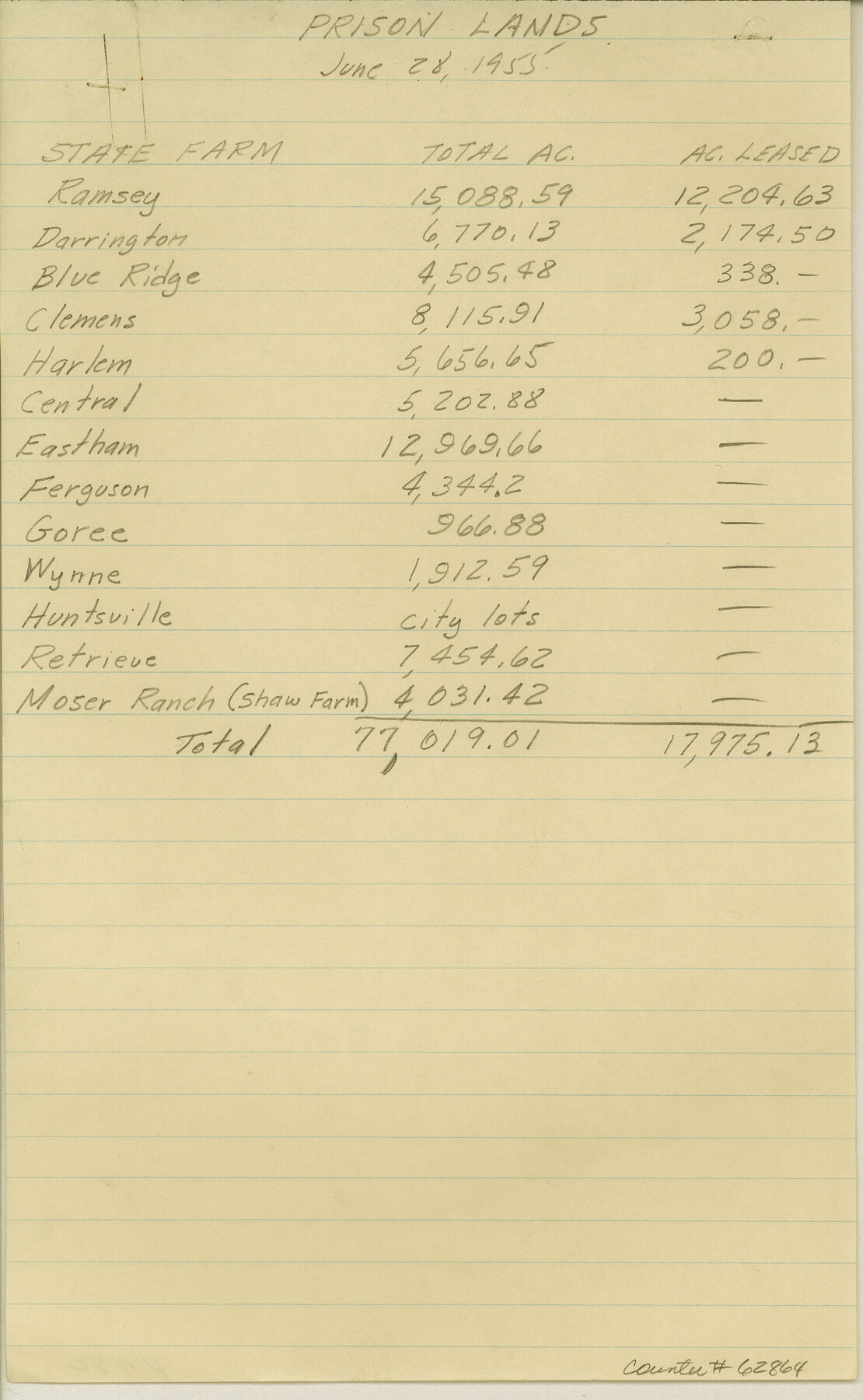
Maps & Lists Showing Prison Lands (Oil & Gas) Leased as of June 1955
K-7-82
-
Map/Doc
62864
-
Collection
General Map Collection
-
Height x Width
11.4 x 7.0 inches
29.0 x 17.8 cm
Part of: General Map Collection
Flight Mission No. CRC-3R, Frame 40, Chambers County

Print $20.00
- Digital $50.00
Flight Mission No. CRC-3R, Frame 40, Chambers County
1956
Size 18.6 x 22.3 inches
Map/Doc 84813
Plat of South 1/2 of Colorado River Channel in McCulloch Co., Texas from Concho County line down river 34 mile 315 varas

Print $40.00
- Digital $50.00
Plat of South 1/2 of Colorado River Channel in McCulloch Co., Texas from Concho County line down river 34 mile 315 varas
1918
Size 41.5 x 104.6 inches
Map/Doc 2463
Kinney County Sketch File 29

Print $20.00
- Digital $50.00
Kinney County Sketch File 29
1933
Size 15.5 x 21.1 inches
Map/Doc 11947
Flight Mission No. BQR-5K, Frame 68, Brazoria County

Print $20.00
- Digital $50.00
Flight Mission No. BQR-5K, Frame 68, Brazoria County
1952
Size 18.8 x 22.5 inches
Map/Doc 84013
Karnes County Working Sketch 2

Print $20.00
- Digital $50.00
Karnes County Working Sketch 2
1939
Size 18.8 x 20.0 inches
Map/Doc 66650
Runnels County Sketch File 29

Print $20.00
Runnels County Sketch File 29
1950
Size 23.8 x 18.0 inches
Map/Doc 12261
Hardeman County Sketch File 19

Print $6.00
- Digital $50.00
Hardeman County Sketch File 19
Size 14.3 x 8.8 inches
Map/Doc 25030
Calhoun County Rolled Sketch 36

Print $40.00
- Digital $50.00
Calhoun County Rolled Sketch 36
2003
Size 33.3 x 49.0 inches
Map/Doc 78655
Current Miscellaneous File 6

Print $4.00
- Digital $50.00
Current Miscellaneous File 6
Size 11.3 x 8.8 inches
Map/Doc 73731
Denton County Working Sketch 30

Print $20.00
- Digital $50.00
Denton County Working Sketch 30
1999
Size 23.2 x 30.4 inches
Map/Doc 68635
Tyler County Working Sketch Graphic Index

Print $20.00
- Digital $50.00
Tyler County Working Sketch Graphic Index
1944
Size 47.4 x 39.6 inches
Map/Doc 76719
Stephens County Rolled Sketch 3

Print $20.00
- Digital $50.00
Stephens County Rolled Sketch 3
1919
Size 34.9 x 19.6 inches
Map/Doc 7840
You may also like
Houston County Working Sketch 32

Print $20.00
- Digital $50.00
Houston County Working Sketch 32
1987
Size 43.9 x 33.0 inches
Map/Doc 66262
K&E Compensating Polar Planimeter

K&E Compensating Polar Planimeter
1972
Size 2.1 x 11.6 inches
Map/Doc 97302
Hutchinson County Rolled Sketch 38

Print $40.00
- Digital $50.00
Hutchinson County Rolled Sketch 38
1953
Size 27.5 x 85.9 inches
Map/Doc 10679
Flight Mission No. BQY-4M, Frame 124, Harris County

Print $20.00
- Digital $50.00
Flight Mission No. BQY-4M, Frame 124, Harris County
1953
Size 18.7 x 22.4 inches
Map/Doc 85292
Donley County Sketch File 5

Print $14.00
- Digital $50.00
Donley County Sketch File 5
Size 12.9 x 8.5 inches
Map/Doc 21223
Harris County Sketch File C

Print $4.00
- Digital $50.00
Harris County Sketch File C
1866
Size 5.9 x 9.8 inches
Map/Doc 25311
Tarrant County Sketch File 27

Print $4.00
- Digital $50.00
Tarrant County Sketch File 27
Size 8.0 x 9.6 inches
Map/Doc 37741
Kenedy County Rolled Sketch 15

Print $15.00
- Digital $50.00
Kenedy County Rolled Sketch 15
1942
Size 10.2 x 15.2 inches
Map/Doc 46426
McMullen County Rolled Sketch 17

Print $40.00
- Digital $50.00
McMullen County Rolled Sketch 17
1950
Map/Doc 9501
Culberson County Working Sketch 62

Print $20.00
- Digital $50.00
Culberson County Working Sketch 62
1975
Size 32.2 x 24.6 inches
Map/Doc 68516
Jefferson County Rolled Sketch 61E

Print $20.00
- Digital $50.00
Jefferson County Rolled Sketch 61E
1928
Size 27.1 x 40.2 inches
Map/Doc 6414
Harrison County Rolled Sketch 11

Print $20.00
- Digital $50.00
Harrison County Rolled Sketch 11
1957
Size 24.7 x 30.2 inches
Map/Doc 6154