Calhoun County Rolled Sketch 36
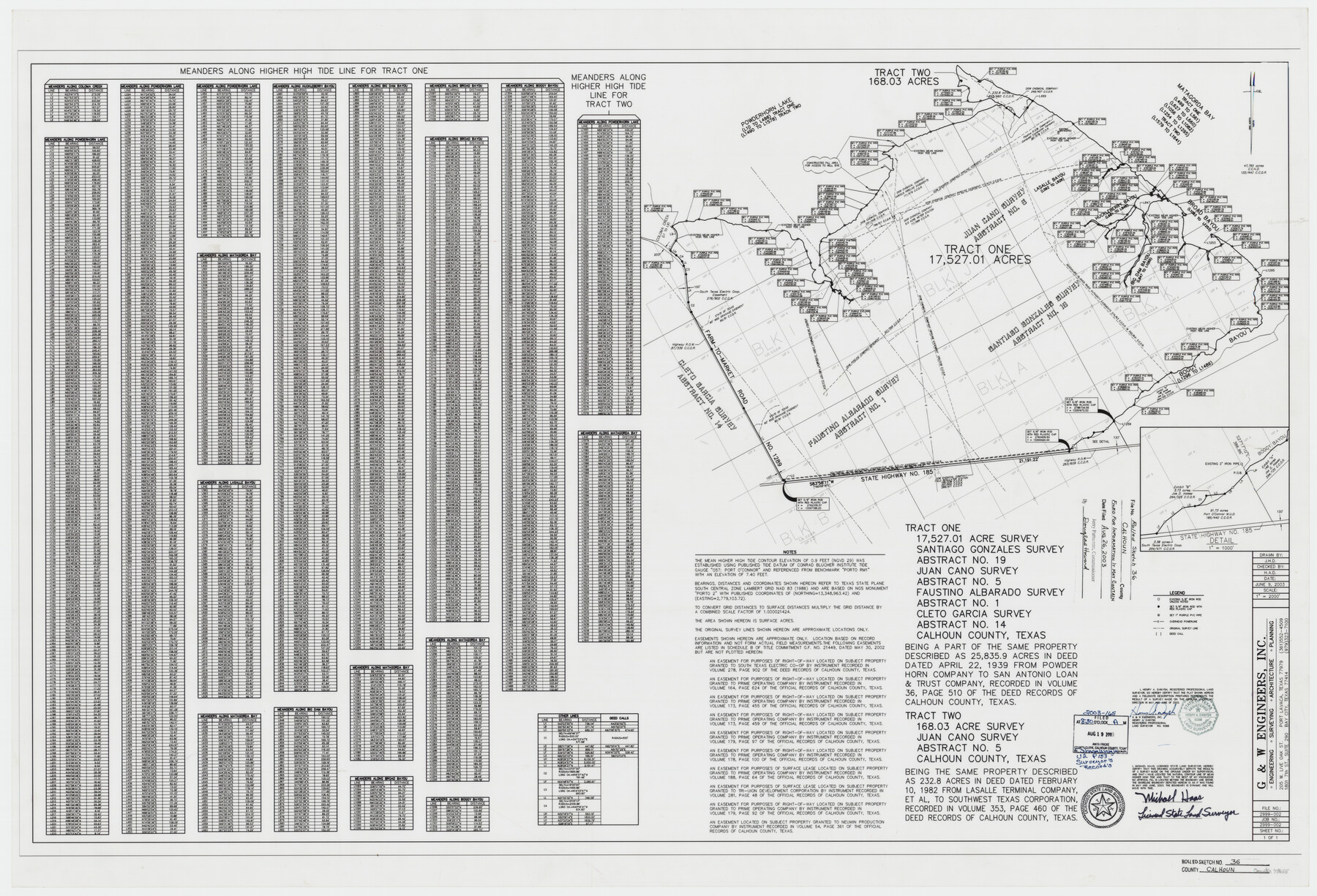
[Plat of two tracts - Tract 1: 17,527.01 acres and Tract 2: 168.03 acres around and composing of parts of Juan Cano survey, abstract 5 and other adjacent surveys, south of Powderhorn Lake]
-
Map/Doc
78655
-
Collection
General Map Collection
-
Object Dates
2003/6/9 (Creation Date)
2003/8/26 (File Date)
-
People and Organizations
Henry A. Danysh (Surveyor/Engineer)
Michael Haas (Surveyor/Engineer)
-
Counties
Calhoun
-
Subjects
Surveying Rolled Sketch
-
Height x Width
33.3 x 49.0 inches
84.6 x 124.5 cm
-
Medium
mylar, print
-
Scale
1" = 2000 feet
-
Comments
Filed for information it may contain.
Part of: General Map Collection
Brewster County Sketch File FN-34

Print $40.00
- Digital $50.00
Brewster County Sketch File FN-34
1943
Size 23.1 x 27.1 inches
Map/Doc 10984
Jeff Davis County Sketch File 3

Print $22.00
- Digital $50.00
Jeff Davis County Sketch File 3
Size 12.3 x 8.6 inches
Map/Doc 27892
Cass County Working Sketch 2

Print $20.00
- Digital $50.00
Cass County Working Sketch 2
1935
Size 24.7 x 36.7 inches
Map/Doc 67905
Menard County Sketch File 18

Print $62.00
- Digital $50.00
Menard County Sketch File 18
1893
Size 8.7 x 8.1 inches
Map/Doc 31516
Bandera County Sketch File 29

Print $40.00
- Digital $50.00
Bandera County Sketch File 29
1939
Size 17.3 x 17.4 inches
Map/Doc 10898

Carson County

Print $20.00
- Digital $50.00
Carson County
1932
Size 43.4 x 38.8 inches
Map/Doc 95449
Schleicher County Sketch File 19

Print $6.00
- Digital $50.00
Schleicher County Sketch File 19
1932
Size 11.5 x 15.1 inches
Map/Doc 36508
[Galveston, Harrisburg & San Antonio Railroad from Cuero to Stockdale]
![64201, [Galveston, Harrisburg & San Antonio Railroad from Cuero to Stockdale], General Map Collection](https://historictexasmaps.com/wmedia_w700/maps/64201.tif.jpg)
Print $20.00
- Digital $50.00
[Galveston, Harrisburg & San Antonio Railroad from Cuero to Stockdale]
1907
Size 14.3 x 34.3 inches
Map/Doc 64201
Right of Way and Track Map Houston & Texas Central R.R. operated by the T. & N.O. R.R. Co., Austin Branch

Print $40.00
- Digital $50.00
Right of Way and Track Map Houston & Texas Central R.R. operated by the T. & N.O. R.R. Co., Austin Branch
1918
Size 26.0 x 58.4 inches
Map/Doc 64556
Atascosa County Sketch File 35

Print $20.00
- Digital $50.00
Atascosa County Sketch File 35
1854
Size 14.4 x 30.0 inches
Map/Doc 10866
Webb County Sketch File 72

Print $24.00
- Digital $50.00
Webb County Sketch File 72
2011
Size 11.0 x 8.5 inches
Map/Doc 90054
You may also like
Right of Way and Track Map of The Missouri, Kansas & Texas Railway of Texas

Print $40.00
- Digital $50.00
Right of Way and Track Map of The Missouri, Kansas & Texas Railway of Texas
1918
Size 25.2 x 106.9 inches
Map/Doc 64531
Hutchinson County Boundary File 5

Print $22.00
- Digital $50.00
Hutchinson County Boundary File 5
Size 4.3 x 45.7 inches
Map/Doc 55314
Laguna Madre, Register No. 1476A

Print $40.00
- Digital $50.00
Laguna Madre, Register No. 1476A
1880
Size 31.3 x 53.3 inches
Map/Doc 73604
Montague County Working Sketch 28

Print $20.00
- Digital $50.00
Montague County Working Sketch 28
1963
Size 36.6 x 31.8 inches
Map/Doc 71094
Liberty County Working Sketch 75

Print $20.00
- Digital $50.00
Liberty County Working Sketch 75
1980
Size 23.2 x 23.8 inches
Map/Doc 70535
[Block XO3, Parts of Blocks Y2 and 1, and vicinity]
![91182, [Block XO3, Parts of Blocks Y2 and 1, and vicinity], Twichell Survey Records](https://historictexasmaps.com/wmedia_w700/maps/91182-1.tif.jpg)
Print $20.00
- Digital $50.00
[Block XO3, Parts of Blocks Y2 and 1, and vicinity]
Size 13.1 x 13.9 inches
Map/Doc 91182
San Patricio County Sketch File 44

Print $12.00
- Digital $50.00
San Patricio County Sketch File 44
1942
Size 11.4 x 8.9 inches
Map/Doc 36267
Leon County Working Sketch 24

Print $20.00
- Digital $50.00
Leon County Working Sketch 24
1967
Size 23.3 x 29.0 inches
Map/Doc 70423
Van Zandt County Sketch File 24a

Print $4.00
- Digital $50.00
Van Zandt County Sketch File 24a
1858
Size 6.2 x 8.1 inches
Map/Doc 39441
Kerr County Working Sketch 36

Print $20.00
- Digital $50.00
Kerr County Working Sketch 36
1991
Size 32.8 x 35.8 inches
Map/Doc 70067
Tyler County Sketch File 19a

Print $4.00
- Digital $50.00
Tyler County Sketch File 19a
Size 8.1 x 14.1 inches
Map/Doc 38672
Flight Mission No. DAG-16K, Frame 72, Matagorda County

Print $20.00
- Digital $50.00
Flight Mission No. DAG-16K, Frame 72, Matagorda County
1952
Size 16.5 x 16.4 inches
Map/Doc 86318