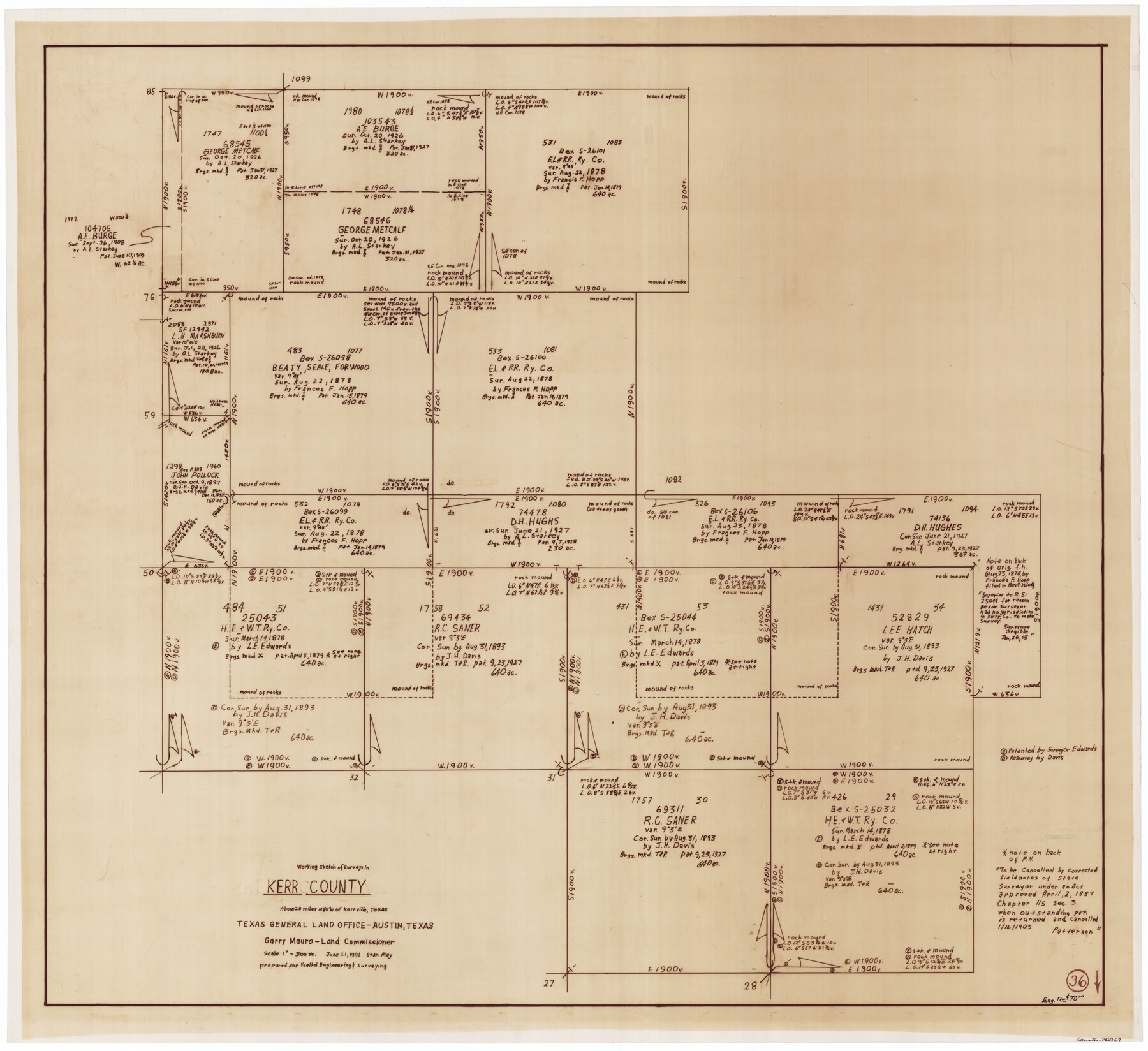
Kerr County Working Sketch 36
-
Map/Doc
70067
-
Collection
General Map Collection
-
Object Dates
6/21/1991 (Creation Date)
-
People and Organizations
Stan May (Draftsman)
-
Counties
Kerr
-
Subjects
Surveying Working Sketch
-
Height x Width
32.8 x 35.8 inches
83.3 x 90.9 cm
-
Scale
1" = 300 varas
Part of: General Map Collection
Taylor County Boundary File 1

Print $44.00
- Digital $50.00
Taylor County Boundary File 1
Size 8.4 x 8.2 inches
Map/Doc 59184

Pecos County Working Sketch 132

Print $40.00
- Digital $50.00
Pecos County Working Sketch 132
1979
Size 34.6 x 49.3 inches
Map/Doc 71606
Mills County Boundary File 7

Print $2.00
- Digital $50.00
Mills County Boundary File 7
Size 14.2 x 8.6 inches
Map/Doc 57312
Carta Politica

Print $20.00
- Digital $50.00
Carta Politica
1897
Size 26.2 x 34.1 inches
Map/Doc 96797
Old Miscellaneous File 27

Print $28.00
- Digital $50.00
Old Miscellaneous File 27
1879
Size 14.4 x 8.8 inches
Map/Doc 75636
Rusk County Sketch File 19a

Print $4.00
Rusk County Sketch File 19a
1860
Size 8.2 x 6.6 inches
Map/Doc 35528
Dimmit County Sketch File 12

Print $104.00
- Digital $50.00
Dimmit County Sketch File 12
1883
Size 31.9 x 33.6 inches
Map/Doc 10366
Culberson County Sketch File 42

Print $14.00
- Digital $50.00
Culberson County Sketch File 42
1966
Size 14.2 x 8.7 inches
Map/Doc 20322
Jones County Boundary File 2

Print $6.00
- Digital $50.00
Jones County Boundary File 2
Size 12.4 x 8.3 inches
Map/Doc 55676
Flight Mission No. DCL-7C, Frame 73, Kenedy County

Print $20.00
- Digital $50.00
Flight Mission No. DCL-7C, Frame 73, Kenedy County
1943
Size 15.6 x 15.3 inches
Map/Doc 86059
Wise County Working Sketch 25

Print $40.00
- Digital $50.00
Wise County Working Sketch 25
1983
Size 37.1 x 53.8 inches
Map/Doc 72639
You may also like
Hale County Rolled Sketch 9

Print $20.00
- Digital $50.00
Hale County Rolled Sketch 9
Size 25.1 x 17.6 inches
Map/Doc 6047
Plan of the City of Austin

Print $40.00
- Digital $50.00
Plan of the City of Austin
1840
Size 56.2 x 42.0 inches
Map/Doc 4837
Galveston County Rolled Sketch 46A

Print $20.00
- Digital $50.00
Galveston County Rolled Sketch 46A
2000
Size 24.9 x 37.6 inches
Map/Doc 5982
Part of a map showing resurvey of Capitol Leagues by R. S. Hunnicutt & Behn Cook State Surveyors

Print $20.00
- Digital $50.00
Part of a map showing resurvey of Capitol Leagues by R. S. Hunnicutt & Behn Cook State Surveyors
Size 21.6 x 17.3 inches
Map/Doc 90277
El Paso County Rolled Sketch 37

Print $40.00
- Digital $50.00
El Paso County Rolled Sketch 37
1916
Size 42.8 x 77.0 inches
Map/Doc 76181
Trinity County Sketch File 40

Print $20.00
- Digital $50.00
Trinity County Sketch File 40
1926
Size 16.5 x 21.8 inches
Map/Doc 12494
Matagorda County Working Sketch 7

Print $20.00
- Digital $50.00
Matagorda County Working Sketch 7
1953
Size 41.0 x 31.8 inches
Map/Doc 70865
Mason County Working Sketch 24

Print $20.00
- Digital $50.00
Mason County Working Sketch 24
2008
Size 20.5 x 26.5 inches
Map/Doc 88825
Val Verde County Working Sketch 49

Print $20.00
- Digital $50.00
Val Verde County Working Sketch 49
1949
Size 26.7 x 41.9 inches
Map/Doc 72184
Val Verde County Sketch File C

Print $62.00
- Digital $50.00
Val Verde County Sketch File C
1898
Size 15.5 x 19.8 inches
Map/Doc 12545
Index sheet to accompany map of survey for connecting the inland waters along margin of the Gulf of Mexico from Donaldsonville in Louisiana to the Rio Grande River in Texas

Print $20.00
- Digital $50.00
Index sheet to accompany map of survey for connecting the inland waters along margin of the Gulf of Mexico from Donaldsonville in Louisiana to the Rio Grande River in Texas
1873
Size 18.2 x 28.1 inches
Map/Doc 72692
Van Zandt County Sketch File 25

Print $4.00
- Digital $50.00
Van Zandt County Sketch File 25
Size 7.6 x 8.8 inches
Map/Doc 39443