Val Verde County Sketch File C
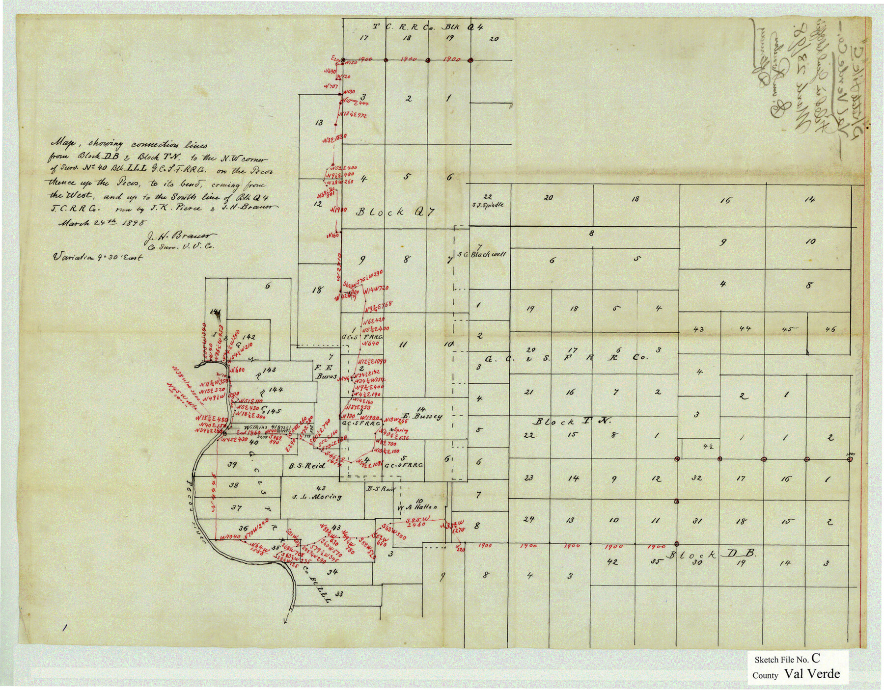
[Sketches and connecting lines from Block DB & Block TN to the northwest corner of survey no. 40, Block LLL on the Pecos, thence up the Pecos to its bend coming from the west and up to the south line of Block Q4]
-
Map/Doc
12545
-
Collection
General Map Collection
-
Object Dates
3/25/1898 (Creation Date)
3/28/1898 (File Date)
-
People and Organizations
John K. Peirce (Surveyor/Engineer)
J.H. Brauer (Surveyor/Engineer)
Bud Larrison (Chainman/Field Personnel)
Henry Bidwell (Chainman/Field Personnel)
-
Counties
Val Verde
-
Subjects
Surveying Sketch File
-
Height x Width
15.5 x 19.8 inches
39.4 x 50.3 cm
-
Medium
multi-page, multi-format
-
Features
Howard's Creek
Pecos River
Rio Grande
Part of: General Map Collection
Harrison County Rolled Sketch 6

Print $20.00
- Digital $50.00
Harrison County Rolled Sketch 6
1952
Size 23.8 x 24.6 inches
Map/Doc 6151
Parker County State Real Property Sketch 1

Print $20.00
- Digital $50.00
Parker County State Real Property Sketch 1
2022
Size 47.4 x 35.1 inches
Map/Doc 96678
Presidio County Rolled Sketch 133

Print $20.00
- Digital $50.00
Presidio County Rolled Sketch 133
Size 37.3 x 27.2 inches
Map/Doc 7400
Kent County Working Sketch 24

Print $20.00
- Digital $50.00
Kent County Working Sketch 24
1988
Size 30.5 x 21.2 inches
Map/Doc 70031
Brewster County

Print $20.00
- Digital $50.00
Brewster County
1920
Size 24.4 x 19.5 inches
Map/Doc 3330
Freestone County

Print $40.00
- Digital $50.00
Freestone County
1918
Size 48.4 x 41.6 inches
Map/Doc 66830
Topographical Map of the Rio Grande, Sheet No. 22

Print $20.00
- Digital $50.00
Topographical Map of the Rio Grande, Sheet No. 22
1912
Map/Doc 89546
Potter County Rolled Sketch 9

Print $20.00
- Digital $50.00
Potter County Rolled Sketch 9
1931
Size 36.7 x 25.3 inches
Map/Doc 7322
Orange County Sketch File 25

Print $20.00
- Digital $50.00
Orange County Sketch File 25
1914
Size 19.6 x 38.2 inches
Map/Doc 12122
Kimble County Working Sketch 20

Print $20.00
- Digital $50.00
Kimble County Working Sketch 20
1929
Size 36.2 x 27.8 inches
Map/Doc 70088
Swisher County Sketch File 8

Print $20.00
- Digital $50.00
Swisher County Sketch File 8
1907
Size 19.2 x 16.3 inches
Map/Doc 12405
Kerr County Working Sketch 27

Print $20.00
- Digital $50.00
Kerr County Working Sketch 27
1970
Size 25.4 x 20.8 inches
Map/Doc 70058
You may also like
Maverick County Boundary File 1

Print $48.00
- Digital $50.00
Maverick County Boundary File 1
Size 14.2 x 8.7 inches
Map/Doc 56901
Grayson County Boundary File 5

Print $4.00
- Digital $50.00
Grayson County Boundary File 5
Size 11.2 x 8.7 inches
Map/Doc 53959
Bosque County Sketch File 6

Print $4.00
- Digital $50.00
Bosque County Sketch File 6
1851
Size 12.1 x 7.6 inches
Map/Doc 14748
[Block 103 H. & G. N., Blocks 140 and 141]
![91676, [Block 103 H. & G. N., Blocks 140 and 141], Twichell Survey Records](https://historictexasmaps.com/wmedia_w700/maps/91676-1.tif.jpg)
Print $20.00
- Digital $50.00
[Block 103 H. & G. N., Blocks 140 and 141]
Size 16.3 x 16.0 inches
Map/Doc 91676
No. 3 Chart of Channel connecting Corpus Christi Bay with Aransas Bay, Texas

Print $20.00
- Digital $50.00
No. 3 Chart of Channel connecting Corpus Christi Bay with Aransas Bay, Texas
1848
Size 18.3 x 27.9 inches
Map/Doc 72777
Brewster County Sketch File NS-4c

Print $6.00
- Digital $50.00
Brewster County Sketch File NS-4c
Size 9.2 x 7.3 inches
Map/Doc 15958

Harris County Working Sketch 82

Print $20.00
- Digital $50.00
Harris County Working Sketch 82
1969
Size 14.9 x 34.5 inches
Map/Doc 65974
Orange County Sketch File 14a

Print $4.00
- Digital $50.00
Orange County Sketch File 14a
1886
Size 8.1 x 10.2 inches
Map/Doc 33328
Erath County Working Sketch 4

Print $20.00
- Digital $50.00
Erath County Working Sketch 4
1919
Size 31.7 x 28.6 inches
Map/Doc 69085
Kerr County Working Sketch 21

Print $40.00
- Digital $50.00
Kerr County Working Sketch 21
1960
Size 24.4 x 54.5 inches
Map/Doc 70052
Sections 13 & 12, Block S

Print $20.00
- Digital $50.00
Sections 13 & 12, Block S
Size 23.0 x 18.2 inches
Map/Doc 92835