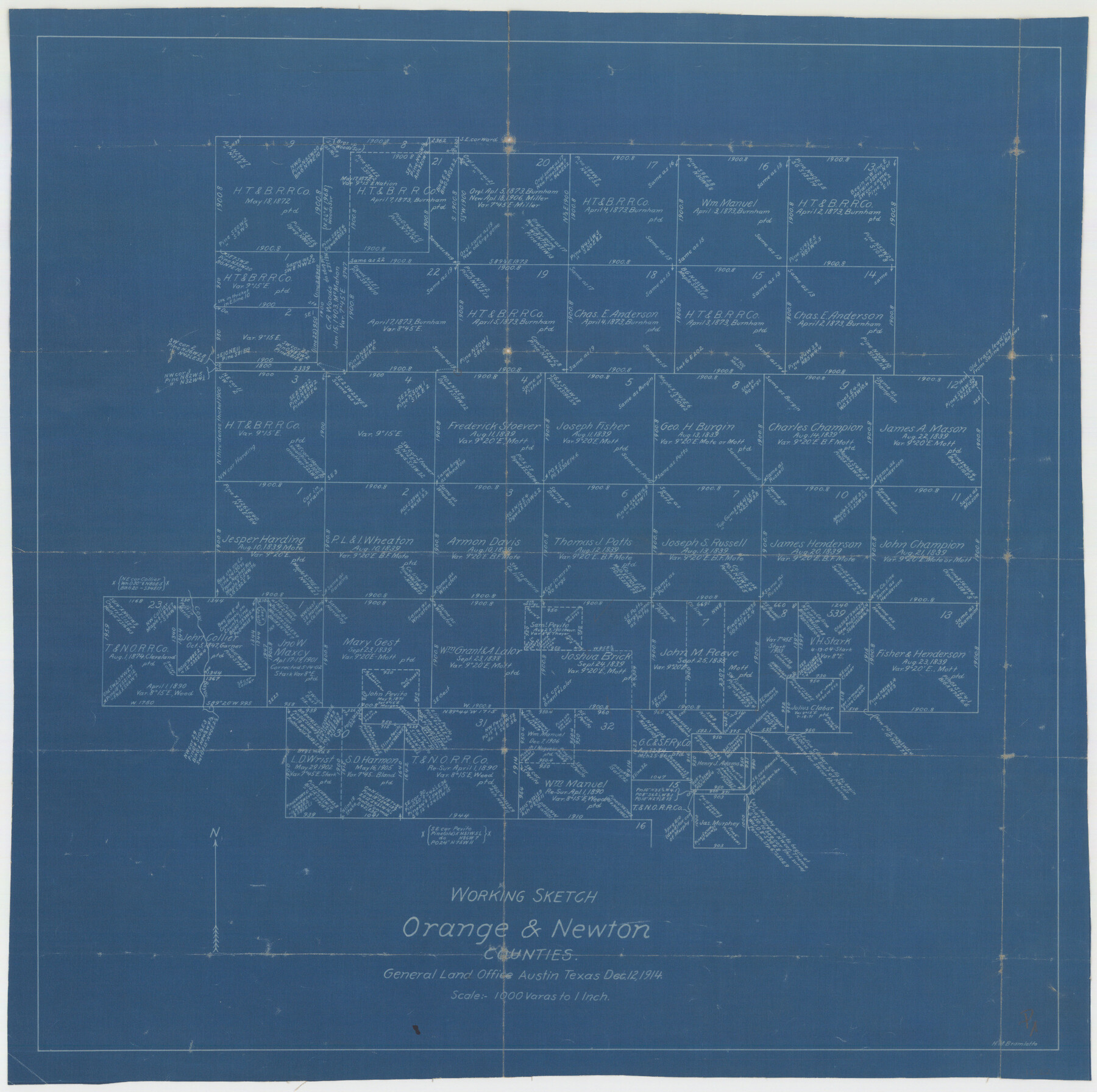
Orange County Sketch File 25
Working Sketch, Orange & Newton Counties
- 
                          Map/Doc12122
- 
                            CollectionGeneral Map Collection
- 
                            Object Dates12/12/1914 (Creation Date)
- 
                            People and OrganizationsH.M. Bramlette (Surveyor/Engineer)
- 
                            CountiesOrange Newton
- 
                            SubjectsSurveying Sketch File
- 
                            Height x Width19.6 x 38.2 inches49.8 x 97.0 cm
- 
                            Mediumblueprint/diazo
- 
                            Scale1" = 1000 varas
Part of: General Map Collection
            Presidio County Rolled Sketch S2


                                            Print $20.00                    
                                             -                         Digital $50.00                                    
                Presidio County Rolled Sketch S2
1916
Size 14.2 x 12.0 inches
                                Map/Doc 7415
            
            Current Miscellaneous File 24a


                                            Print $8.00                    
                                             -                         Digital $50.00                                    
                Current Miscellaneous File 24a
1949
Size 11.0 x 8.6 inches
                                Map/Doc 73893
            
            Dallas County Boundary File 7 and 7a and 7b


                                            Print $26.00                    
                                             -                         Digital $50.00                                    
                Dallas County Boundary File 7 and 7a and 7b
Size 11.2 x 8.6 inches
                                Map/Doc 52278
            
            Comal County Working Sketch 1


                                            Print $20.00                    
                                             -                         Digital $50.00                                    
                Comal County Working Sketch 1
1919
Size 22.1 x 18.2 inches
                                Map/Doc 68167
            
            Goliad County Sketch File 25


                                            Print $6.00                    
                                             -                         Digital $50.00                                    
                Goliad County Sketch File 25
1856
Size 12.3 x 7.8 inches
                                Map/Doc 24305
            
            Flight Mission No. CUG-3P, Frame 136, Kleberg County


                                            Print $20.00                    
                                             -                         Digital $50.00                                    
                Flight Mission No. CUG-3P, Frame 136, Kleberg County
1956
Size 18.5 x 22.3 inches
                                Map/Doc 86271
            
            Tom Green County Sketch File 66


                                            Print $22.00                    
                                             -                         Digital $50.00                                    
                Tom Green County Sketch File 66
1929
Size 16.8 x 14.6 inches
                                Map/Doc 38236
            
            Nolan County Sketch File A


                                            Print $20.00                    
                                             -                         Digital $50.00                                    
                Nolan County Sketch File A
Size 22.4 x 19.9 inches
                                Map/Doc 42170
            
            Somervell County Working Sketch 6


                                            Print $20.00                    
                                             -                         Digital $50.00                                    
                Somervell County Working Sketch 6
1992
Size 23.2 x 21.5 inches
                                Map/Doc 63910
            
            Presidio County Rolled Sketch 85


                                            Print $20.00                    
                                             -                         Digital $50.00                                    
                Presidio County Rolled Sketch 85
1930
Size 28.3 x 27.3 inches
                                Map/Doc 7371
            
            [Surveys in the Robertson District along the Trinity River and Richland Creek]
            
                                    ![104, [Surveys in the Robertson District along the Trinity River and Richland Creek], General Map Collection](https://historictexasmaps.com/wmedia_w700/maps/104.tif.jpg) 


    ![104, [Surveys in the Robertson District along the Trinity River and Richland Creek], General Map Collection](https://historictexasmaps.com/wmedia_w700/maps/104.tif.jpg) 
                                
            
                                            Print $20.00                    
                                             -                         Digital $50.00                                    
                [Surveys in the Robertson District along the Trinity River and Richland Creek]
1841
Size 15.3 x 12.2 inches
                                Map/Doc 104
            
            [Aerial photograph showing R. H. Welder Ranch, San Patricio County, Texas]
            
                                    ![61407, [Aerial photograph showing R. H. Welder Ranch, San Patricio County, Texas], General Map Collection](https://historictexasmaps.com/wmedia_w700/maps/61407.tif.jpg) 


    ![61407, [Aerial photograph showing R. H. Welder Ranch, San Patricio County, Texas], General Map Collection](https://historictexasmaps.com/wmedia_w700/maps/61407.tif.jpg) 
                                
            
                                            Print $20.00                    
                                             -                         Digital $50.00                                    
                [Aerial photograph showing R. H. Welder Ranch, San Patricio County, Texas]
Size 23.0 x 39.5 inches
                                Map/Doc 61407
            You may also like
            Midland County Working Sketch 18


                                            Print $40.00                    
                                             -                         Digital $50.00                                    
                Midland County Working Sketch 18
1956
Size 26.5 x 49.5 inches
                                Map/Doc 70998
            
            R. C. Johnson Farm NW Quarter, Section 3


                                            Print $20.00                    
                                             -                         Digital $50.00                                    
                R. C. Johnson Farm NW Quarter, Section 3
Size 12.3 x 14.9 inches
                                Map/Doc 92405
            
            Live Oak County Rolled Sketch 9


                                            Print $20.00                    
                                             -                         Digital $50.00                                    
                Live Oak County Rolled Sketch 9
1982
Size 25.6 x 23.3 inches
                                Map/Doc 6636
            
            Harris County Rolled Sketch WHW2


                                            Print $20.00                    
                                             -                         Digital $50.00                                    
                Harris County Rolled Sketch WHW2
Size 15.5 x 14.4 inches
                                Map/Doc 6148
            
            Stonewall County Sketch File 25


                                            Print $7.00                    
                                             -                         Digital $50.00                                    
                Stonewall County Sketch File 25
1952
Size 26.7 x 43.3 inches
                                Map/Doc 10375
            
            Gray County Sketch File 7c


                                            Print $20.00                    
                                             -                         Digital $50.00                                    
                Gray County Sketch File 7c
1885
Size 26.5 x 19.6 inches
                                Map/Doc 11576
            
            Presidio County Sketch File 44


                                            Print $15.00                    
                                             -                         Digital $50.00                                    
                Presidio County Sketch File 44
1913
Size 11.1 x 9.5 inches
                                Map/Doc 34525
            
            Crockett County Sketch File 79


                                            Print $18.00                    
                                             -                         Digital $50.00                                    
                Crockett County Sketch File 79
1937
Size 11.1 x 8.8 inches
                                Map/Doc 19881
            
            Grayson County Boundary File 5


                                            Print $4.00                    
                                             -                         Digital $50.00                                    
                Grayson County Boundary File 5
Size 11.2 x 8.7 inches
                                Map/Doc 53959
            
            Dallas County Sketch File 22


                                            Print $6.00                    
                                             -                         Digital $50.00                                    
                Dallas County Sketch File 22
1891
Size 9.5 x 10.9 inches
                                Map/Doc 20454
            
            Map of the City of Austin


                                            Print $20.00                    
                                             -                         Digital $50.00                                    
                Map of the City of Austin
1876
Size 36.5 x 30.4 inches
                                Map/Doc 78477
             
                            