Nueces County Rolled Sketch 127 A-F
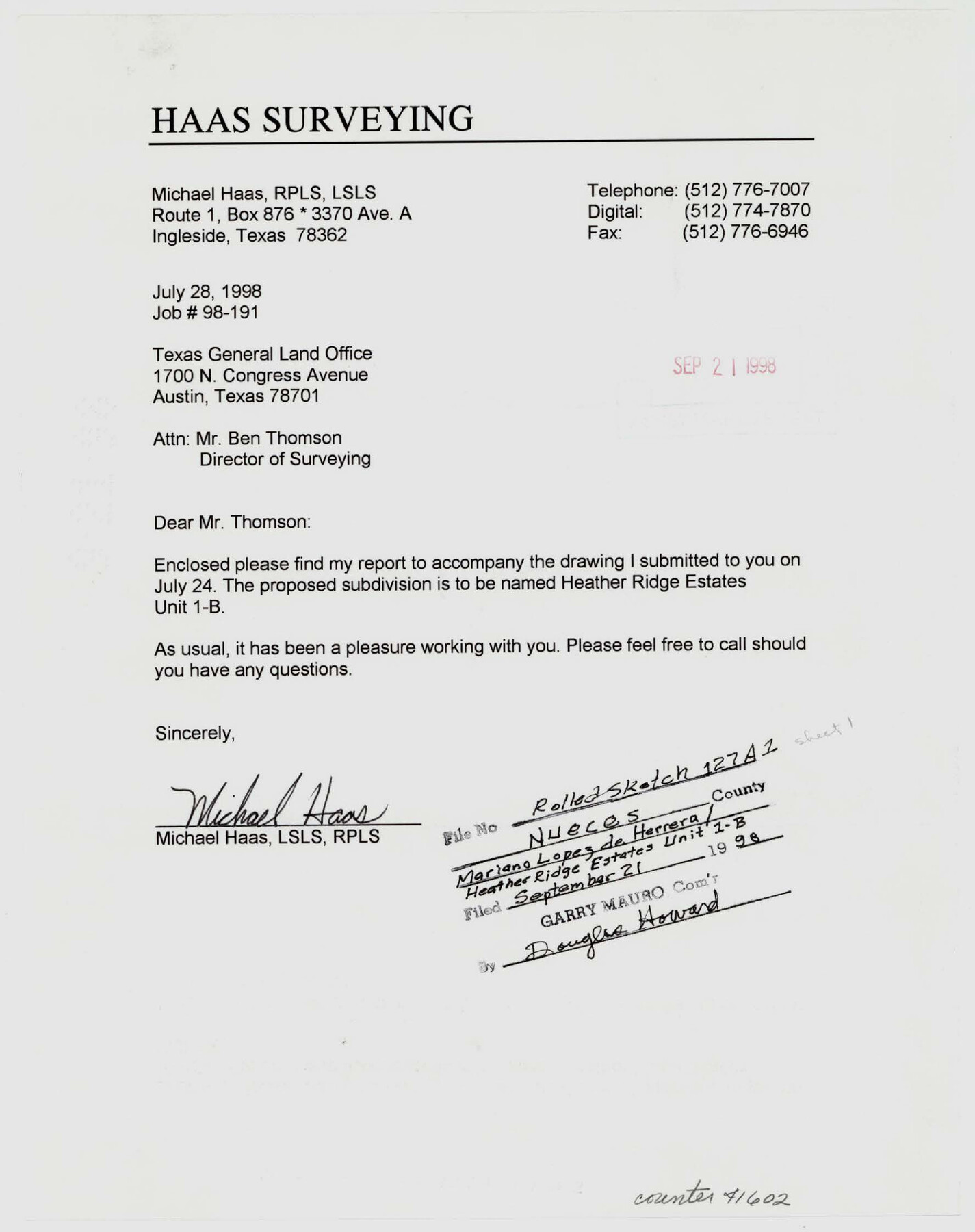
[Surveyor's report and correspondence relating to gradient boundary determination along a portion of Nueces River for proposed subdivision named Heather Ridge Estates]
-
Map/Doc
8976
-
Collection
General Map Collection
-
Object Dates
1998 (Creation Date)
1998/10/8 (File Date)
-
People and Organizations
Michael Haas (Surveyor/Engineer)
-
Counties
Nueces
-
Subjects
Surveying Rolled Sketch
-
Height x Width
11.1 x 26.6 inches
28.2 x 67.6 cm
-
Medium
paper, print
-
Comments
See Nueces County Rolled Sketch 127 (7162) for sketch.
Related maps
Nueces County Rolled Sketch 127

Print $20.00
- Digital $50.00
Nueces County Rolled Sketch 127
1998
Size 24.1 x 36.4 inches
Map/Doc 7162
Part of: General Map Collection
Carson County Boundary File 10

Print $2.00
- Digital $50.00
Carson County Boundary File 10
Size 11.5 x 7.2 inches
Map/Doc 51185
Gaines County Boundary File 1

Print $90.00
- Digital $50.00
Gaines County Boundary File 1
Size 14.4 x 9.0 inches
Map/Doc 53626
Flight Mission No. BRA-9M, Frame 81, Jefferson County

Print $20.00
- Digital $50.00
Flight Mission No. BRA-9M, Frame 81, Jefferson County
1953
Size 18.3 x 22.6 inches
Map/Doc 85664
Kerr County Working Sketch 25

Print $20.00
- Digital $50.00
Kerr County Working Sketch 25
Size 21.5 x 28.5 inches
Map/Doc 70056
[Sketch for Mineral Application 33721 - 33725 Incl. - Padre and Mustang Island]
![2870, [Sketch for Mineral Application 33721 - 33725 Incl. - Padre and Mustang Island], General Map Collection](https://historictexasmaps.com/wmedia_w700/maps/2870.tif.jpg)
Print $20.00
- Digital $50.00
[Sketch for Mineral Application 33721 - 33725 Incl. - Padre and Mustang Island]
1942
Size 22.1 x 22.4 inches
Map/Doc 2870
Pecos County Rolled Sketch DK2

Print $20.00
- Digital $50.00
Pecos County Rolled Sketch DK2
1938
Size 31.8 x 40.0 inches
Map/Doc 9714
Brazoria County Sketch File 26

Print $40.00
- Digital $50.00
Brazoria County Sketch File 26
Size 13.6 x 13.6 inches
Map/Doc 15028
Brewster County Rolled Sketch 24C

Print $20.00
- Digital $50.00
Brewster County Rolled Sketch 24C
Size 17.5 x 20.8 inches
Map/Doc 5210
Gaines County

Print $20.00
- Digital $50.00
Gaines County
1956
Size 32.2 x 40.6 inches
Map/Doc 77286
Orange County Sketch File 42

Print $40.00
- Digital $50.00
Orange County Sketch File 42
1873
Size 12.8 x 15.8 inches
Map/Doc 33383
Lubbock County Boundary File 9

Print $55.00
- Digital $50.00
Lubbock County Boundary File 9
Size 17.0 x 11.0 inches
Map/Doc 56530
Current Miscellaneous File 98

Print $40.00
- Digital $50.00
Current Miscellaneous File 98
Size 18.4 x 26.3 inches
Map/Doc 74338
You may also like
Runnels County Sketch File 15

Print $42.00
Runnels County Sketch File 15
1883
Size 9.2 x 7.9 inches
Map/Doc 35459
Val Verde County Working Sketch 58

Print $20.00
- Digital $50.00
Val Verde County Working Sketch 58
1958
Size 21.0 x 22.8 inches
Map/Doc 72193


[H. & G. N. Block 1]
![90939, [H. & G. N. Block 1], Twichell Survey Records](https://historictexasmaps.com/wmedia_w700/maps/90939-1.tif.jpg)
Print $20.00
- Digital $50.00
[H. & G. N. Block 1]
1902
Size 13.5 x 16.4 inches
Map/Doc 90939
Briscoe County Sketch File 12

Print $4.00
- Digital $50.00
Briscoe County Sketch File 12
1927
Size 11.2 x 8.8 inches
Map/Doc 16426
Right of Way Location Map, San Antonio & Aransas Pass, Station 656…

Print $4.00
- Digital $50.00
Right of Way Location Map, San Antonio & Aransas Pass, Station 656…
1919
Size 11.8 x 18.6 inches
Map/Doc 62567
Loving County Working Sketch 16

Print $40.00
- Digital $50.00
Loving County Working Sketch 16
1973
Size 33.3 x 54.1 inches
Map/Doc 70649
Crockett County Sketch File 58a

Print $20.00
- Digital $50.00
Crockett County Sketch File 58a
1923
Size 21.1 x 25.8 inches
Map/Doc 5601
Menard County Boundary File 13a

Print $6.00
- Digital $50.00
Menard County Boundary File 13a
Size 11.2 x 8.7 inches
Map/Doc 57137
Collin County State Real Property Sketch 1

Print $20.00
- Digital $50.00
Collin County State Real Property Sketch 1
2006
Size 24.1 x 35.1 inches
Map/Doc 88634
[Mrs. May Vinson Survey]
![91877, [Mrs. May Vinson Survey], Twichell Survey Records](https://historictexasmaps.com/wmedia_w700/maps/91877-1.tif.jpg)
Print $20.00
- Digital $50.00
[Mrs. May Vinson Survey]
Size 26.7 x 14.8 inches
Map/Doc 91877