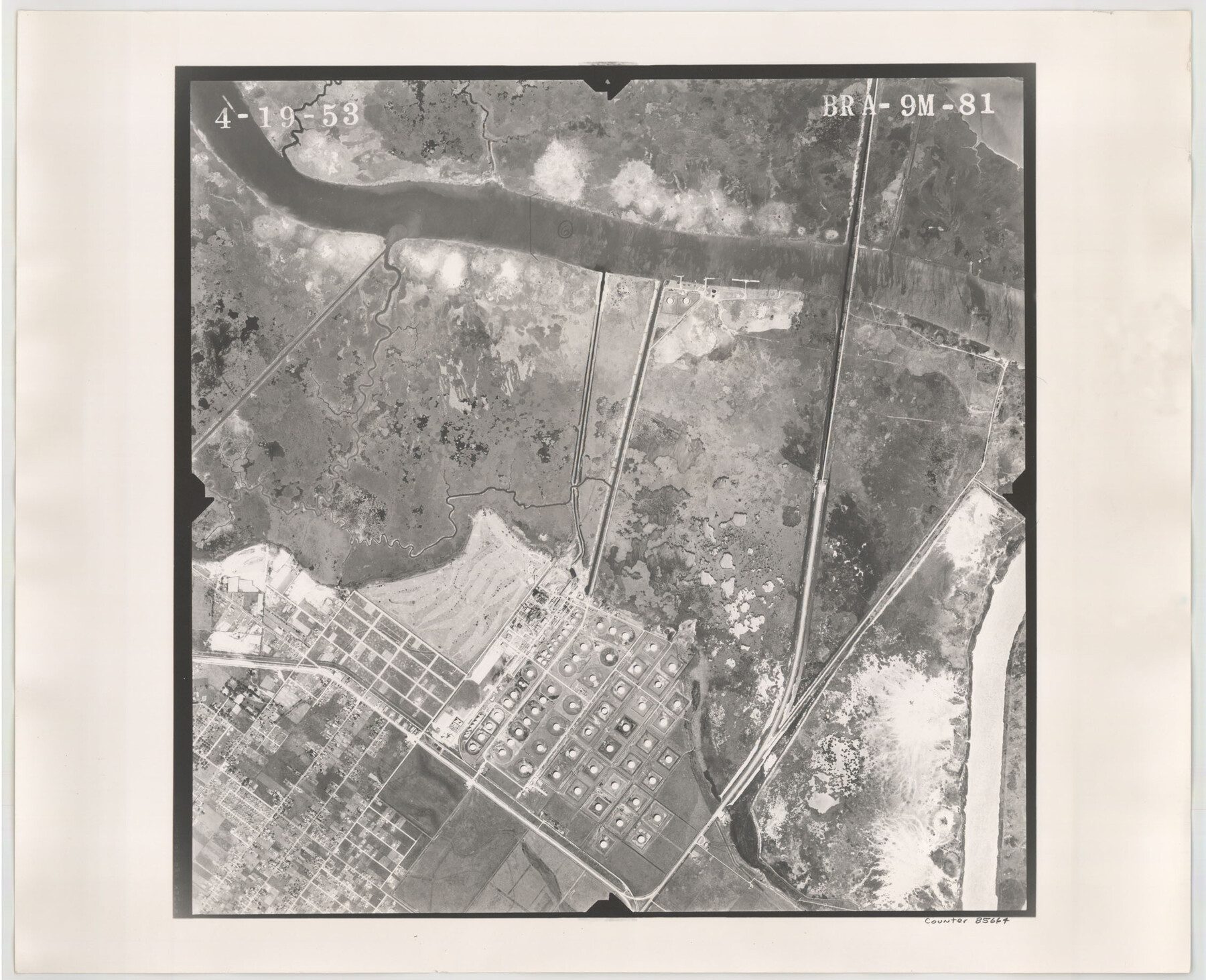
Flight Mission No. BRA-9M, Frame 81, Jefferson County
BRA-9M-81
-
Map/Doc
85664
-
Collection
General Map Collection
-
Object Dates
1953/4/19 (Creation Date)
-
People and Organizations
U. S. Department of Agriculture (Publisher)
-
Counties
Jefferson
-
Subjects
Aerial Photograph
-
Height x Width
18.3 x 22.6 inches
46.5 x 57.4 cm
-
Comments
Flown by Jack Ammann Photogrammetric Engineers of San Antonio, Texas.
Part of: General Map Collection
Greater Austin, Texas Streetmap

Greater Austin, Texas Streetmap
Size 45.8 x 36.2 inches
Map/Doc 94431
The City of Austin and Suburbs

Print $40.00
- Digital $50.00
The City of Austin and Suburbs
1919
Size 120.7 x 41.2 inches
Map/Doc 88863
Johnson's New Military Map of the United States Showing the Forts, Military Posts & c. with Enlarged Plans of Southern Harbors

Print $20.00
- Digital $50.00
Johnson's New Military Map of the United States Showing the Forts, Military Posts & c. with Enlarged Plans of Southern Harbors
1863
Size 17.7 x 23.3 inches
Map/Doc 93289
Uvalde County Working Sketch 32

Print $20.00
- Digital $50.00
Uvalde County Working Sketch 32
1962
Size 27.2 x 41.8 inches
Map/Doc 72102
McMullen County Working Sketch 8

Print $20.00
- Digital $50.00
McMullen County Working Sketch 8
1936
Size 27.2 x 33.0 inches
Map/Doc 70709
Brewster County Working Sketch 65

Print $20.00
- Digital $50.00
Brewster County Working Sketch 65
1958
Size 40.2 x 34.8 inches
Map/Doc 67666
Liberty County Working Sketch 64

Print $20.00
- Digital $50.00
Liberty County Working Sketch 64
1970
Size 21.3 x 26.8 inches
Map/Doc 70524
Flight Mission No. BRE-1P, Frame 107, Nueces County

Print $20.00
- Digital $50.00
Flight Mission No. BRE-1P, Frame 107, Nueces County
1956
Size 18.5 x 22.6 inches
Map/Doc 86678
Jeff Davis County Rolled Sketch 33

Print $20.00
- Digital $50.00
Jeff Davis County Rolled Sketch 33
1986
Size 39.8 x 30.6 inches
Map/Doc 6379
Flight Mission No. DIX-8P, Frame 83, Aransas County

Print $20.00
- Digital $50.00
Flight Mission No. DIX-8P, Frame 83, Aransas County
1956
Size 18.6 x 22.3 inches
Map/Doc 83908
Orange County Working Sketch 35

Print $20.00
- Digital $50.00
Orange County Working Sketch 35
1959
Size 28.8 x 25.0 inches
Map/Doc 71367
Louisiana and Texas Intracoastal Waterway

Print $20.00
- Digital $50.00
Louisiana and Texas Intracoastal Waterway
1929
Size 13.6 x 19.8 inches
Map/Doc 83345
You may also like
Pecos County Working Sketch 126

Print $20.00
- Digital $50.00
Pecos County Working Sketch 126
1936
Size 15.3 x 27.4 inches
Map/Doc 71600
Map of Texas, compiled from surveys on record in the General Land Office of the Republic

Print $20.00
- Digital $50.00
Map of Texas, compiled from surveys on record in the General Land Office of the Republic
1839
Size 33.0 x 25.3 inches
Map/Doc 93858

Val Verde County Working Sketch 9

Print $20.00
- Digital $50.00
Val Verde County Working Sketch 9
1917
Size 19.4 x 30.9 inches
Map/Doc 72144
Flight Mission No. CGI-1N, Frame 171, Cameron County

Print $20.00
- Digital $50.00
Flight Mission No. CGI-1N, Frame 171, Cameron County
1955
Size 18.5 x 22.2 inches
Map/Doc 84506
General Highway Map, Washington County, Texas

Print $20.00
General Highway Map, Washington County, Texas
1940
Size 18.4 x 25.0 inches
Map/Doc 79272
El Paso County Rolled Sketch 52

Print $20.00
- Digital $50.00
El Paso County Rolled Sketch 52
1930
Size 18.5 x 24.4 inches
Map/Doc 5837
Map of Bexar County

Print $20.00
- Digital $50.00
Map of Bexar County
1879
Size 24.2 x 27.6 inches
Map/Doc 4508
Hudspeth County Sketch File 14

Print $12.00
- Digital $50.00
Hudspeth County Sketch File 14
1915
Size 14.3 x 8.8 inches
Map/Doc 26938
Bell County Sketch File 33

Print $6.00
- Digital $50.00
Bell County Sketch File 33
Size 14.4 x 8.7 inches
Map/Doc 14452
Presidio County Working Sketch 145

Print $20.00
- Digital $50.00
Presidio County Working Sketch 145
1990
Size 29.5 x 42.7 inches
Map/Doc 71823
Kinney County Sketch File 22

Print $6.00
- Digital $50.00
Kinney County Sketch File 22
1891
Size 10.1 x 12.3 inches
Map/Doc 29160