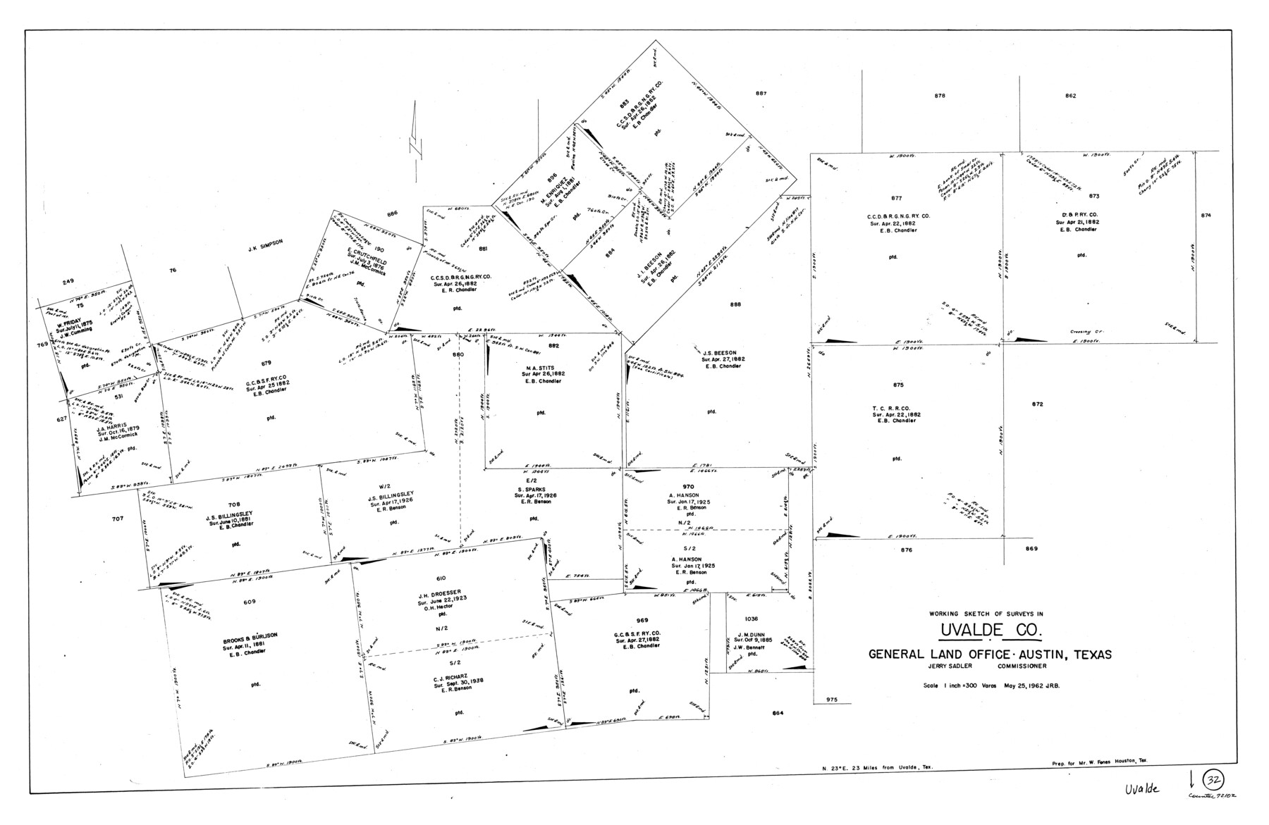
Uvalde County Working Sketch 32
-
Map/Doc
72102
-
Collection
General Map Collection
-
Object Dates
5/25/1962 (Creation Date)
-
Counties
Uvalde
-
Subjects
Surveying Working Sketch
-
Height x Width
27.2 x 41.8 inches
69.1 x 106.2 cm
-
Scale
1" = 300 varas
Part of: General Map Collection
Flight Mission No. BRE-2P, Frame 7, Nueces County

Print $20.00
- Digital $50.00
Flight Mission No. BRE-2P, Frame 7, Nueces County
1956
Size 18.5 x 22.4 inches
Map/Doc 86716
Atascosa County Rolled Sketch 12

Print $40.00
- Digital $50.00
Atascosa County Rolled Sketch 12
1944
Size 33.3 x 68.8 inches
Map/Doc 8429
Jack County Sketch File 35

Print $20.00
- Digital $50.00
Jack County Sketch File 35
1958
Size 23.9 x 35.6 inches
Map/Doc 11833
Somervell County Working Sketch 6

Print $20.00
- Digital $50.00
Somervell County Working Sketch 6
1992
Size 23.2 x 21.5 inches
Map/Doc 63910
Midland County Rolled Sketch 11

Print $20.00
- Digital $50.00
Midland County Rolled Sketch 11
Size 45.7 x 26.2 inches
Map/Doc 6767
Cottle County Rolled Sketch 11

Print $20.00
- Digital $50.00
Cottle County Rolled Sketch 11
1927
Size 31.6 x 24.1 inches
Map/Doc 5568
Real County Rolled Sketch 6

Print $20.00
- Digital $50.00
Real County Rolled Sketch 6
Size 28.0 x 23.7 inches
Map/Doc 7456
Trinity River, Hutchins Bridge Sheet

Print $20.00
- Digital $50.00
Trinity River, Hutchins Bridge Sheet
1922
Size 38.6 x 33.2 inches
Map/Doc 65190
Fort Bend County Sketch File 10

Print $20.00
- Digital $50.00
Fort Bend County Sketch File 10
Size 16.9 x 24.9 inches
Map/Doc 11501
Coke County Working Sketch 23

Print $20.00
- Digital $50.00
Coke County Working Sketch 23
1954
Size 42.4 x 35.7 inches
Map/Doc 68060
Castro County Sketch File 10

Print $6.00
- Digital $50.00
Castro County Sketch File 10
1916
Size 8.2 x 5.4 inches
Map/Doc 17501
Yoakum County Sketch File 13

Print $49.00
- Digital $50.00
Yoakum County Sketch File 13
1898
Size 8.3 x 8.6 inches
Map/Doc 40767
You may also like
Flight Mission No. CRC-4R, Frame 105, Chambers County

Print $20.00
- Digital $50.00
Flight Mission No. CRC-4R, Frame 105, Chambers County
1956
Size 18.8 x 22.4 inches
Map/Doc 84902
Flight Mission No. BRA-9M, Frame 71, Jefferson County

Print $20.00
- Digital $50.00
Flight Mission No. BRA-9M, Frame 71, Jefferson County
1953
Size 18.5 x 22.4 inches
Map/Doc 85654
Orange County Boundary File 7

Print $10.00
- Digital $50.00
Orange County Boundary File 7
Size 4.1 x 7.6 inches
Map/Doc 57775
Jefferson County Sketch File 18

Print $40.00
- Digital $50.00
Jefferson County Sketch File 18
Size 15.7 x 14.0 inches
Map/Doc 28167
Map of Young County

Print $20.00
- Digital $50.00
Map of Young County
1896
Size 41.6 x 35.0 inches
Map/Doc 4172
Baylor County Sketch File Z1

Print $12.00
- Digital $50.00
Baylor County Sketch File Z1
1901
Size 8.8 x 7.2 inches
Map/Doc 14104
Blanco County Working Sketch 24

Print $20.00
- Digital $50.00
Blanco County Working Sketch 24
1963
Size 30.2 x 31.2 inches
Map/Doc 67384
[Travis District]
![88739, [Travis District], General Map Collection](https://historictexasmaps.com/wmedia_w700/maps/88739.tif.jpg)
Print $40.00
- Digital $50.00
[Travis District]
1840
Size 54.7 x 42.0 inches
Map/Doc 88739
Kimble County Sketch File L1

Print $22.00
- Digital $50.00
Kimble County Sketch File L1
Size 7.1 x 13.1 inches
Map/Doc 28967
Flight Mission No. DAG-23K, Frame 169, Matagorda County

Print $20.00
- Digital $50.00
Flight Mission No. DAG-23K, Frame 169, Matagorda County
1953
Size 16.0 x 15.8 inches
Map/Doc 86507
[Blocks 10T, O7, S2, S3, T2, T3, JB and A]
![89953, [Blocks 10T, O7, S2, S3, T2, T3, JB and A], Twichell Survey Records](https://historictexasmaps.com/wmedia_w700/maps/89953-1.tif.jpg)
Print $20.00
- Digital $50.00
[Blocks 10T, O7, S2, S3, T2, T3, JB and A]
Size 41.8 x 37.7 inches
Map/Doc 89953
Presidio County Working Sketch 69

Print $20.00
- Digital $50.00
Presidio County Working Sketch 69
1960
Size 33.3 x 41.3 inches
Map/Doc 71746