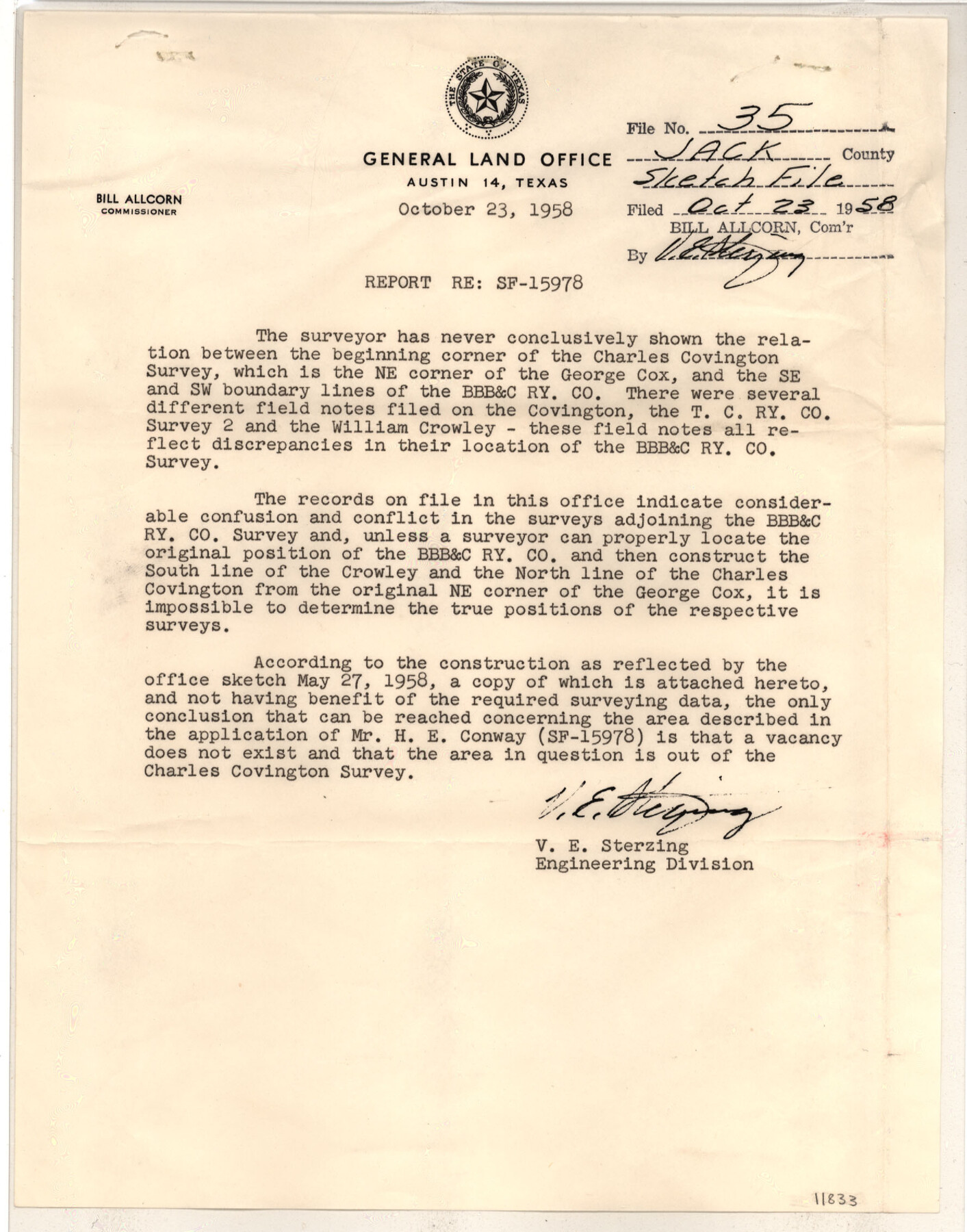
Jack County Sketch File 35
[Office sketch and examiner's report regarding SF-15978 in the northwest part of the county]
-
Map/Doc
11833
-
Collection
General Map Collection
-
Object Dates
5/27/1958 (Creation Date)
10/23/1958 (File Date)
-
People and Organizations
Victor E. Sterzing (Surveyor/Engineer)
-
Counties
Jack
-
Subjects
Surveying Sketch File
-
Height x Width
23.9 x 35.6 inches
60.7 x 90.4 cm
-
Medium
multi-page, multi-format
-
Scale
1" = 300 varas
Part of: General Map Collection
Right of Way Map, Belton Branch of the M.K.&T. RR.

Print $20.00
- Digital $50.00
Right of Way Map, Belton Branch of the M.K.&T. RR.
1896
Size 14.5 x 42.1 inches
Map/Doc 64219
Crosby County Sketch File 32

Print $20.00
- Digital $50.00
Crosby County Sketch File 32
1938
Size 23.2 x 31.8 inches
Map/Doc 11258
Henderson County Sketch File 8a

Print $18.00
- Digital $50.00
Henderson County Sketch File 8a
1861
Size 10.3 x 8.4 inches
Map/Doc 26334
Webb County Working Sketch 50

Print $20.00
- Digital $50.00
Webb County Working Sketch 50
1950
Size 22.9 x 24.9 inches
Map/Doc 72415
Montgomery County Sketch File 20

Print $38.00
- Digital $50.00
Montgomery County Sketch File 20
1932
Size 14.3 x 8.8 inches
Map/Doc 31847
Erath County Working Sketch 43

Print $20.00
- Digital $50.00
Erath County Working Sketch 43
1981
Size 19.6 x 15.7 inches
Map/Doc 69124
Wheeler County

Print $20.00
- Digital $50.00
Wheeler County
1878
Size 18.5 x 16.6 inches
Map/Doc 4140
Reeves County Rolled Sketch 30

Print $20.00
- Digital $50.00
Reeves County Rolled Sketch 30
1988
Size 18.4 x 24.4 inches
Map/Doc 7499
Hudspeth County Rolled Sketch 20

Print $20.00
- Digital $50.00
Hudspeth County Rolled Sketch 20
Size 39.5 x 44.3 inches
Map/Doc 76028
Duval County Working Sketch 3

Print $40.00
- Digital $50.00
Duval County Working Sketch 3
1925
Size 59.1 x 45.0 inches
Map/Doc 76444
Leon County Working Sketch 52a

Print $20.00
- Digital $50.00
Leon County Working Sketch 52a
1982
Size 35.1 x 42.8 inches
Map/Doc 70451
Val Verde County Boundary File 103

Print $82.00
- Digital $50.00
Val Verde County Boundary File 103
Size 9.1 x 9.1 inches
Map/Doc 59577
You may also like
Harris County Working Sketch 76

Print $20.00
- Digital $50.00
Harris County Working Sketch 76
1966
Size 32.2 x 24.2 inches
Map/Doc 65968
Pecos County Rolled Sketch 167

Print $20.00
- Digital $50.00
Pecos County Rolled Sketch 167
1886
Size 41.1 x 27.1 inches
Map/Doc 7291
Jeff Davis County Working Sketch 14

Print $20.00
- Digital $50.00
Jeff Davis County Working Sketch 14
1949
Size 21.5 x 25.8 inches
Map/Doc 66509
Working Sketch in Baylor and Throckmorton Cos.

Print $20.00
- Digital $50.00
Working Sketch in Baylor and Throckmorton Cos.
1890
Size 24.2 x 20.8 inches
Map/Doc 75771
Howard County Sketch File 9

Print $20.00
- Digital $50.00
Howard County Sketch File 9
Size 19.4 x 15.9 inches
Map/Doc 11797
General Highway Map, Burnet County, Texas

Print $20.00
General Highway Map, Burnet County, Texas
1940
Size 18.4 x 25.0 inches
Map/Doc 79035
Brewster County Rolled Sketch 114

Print $20.00
- Digital $50.00
Brewster County Rolled Sketch 114
1964
Size 11.4 x 17.7 inches
Map/Doc 5284
Caldwell County Sketch File 4a

Print $8.00
- Digital $50.00
Caldwell County Sketch File 4a
1898
Size 11.2 x 8.8 inches
Map/Doc 35835
Bird's Eye View of McKinney, County Seat of Collin Co[unty], Texas
![89099, Bird's Eye View of McKinney, County Seat of Collin Co[unty], Texas, Non-GLO Digital Images](https://historictexasmaps.com/wmedia_w700/maps/89099.tif.jpg)
Print $20.00
Bird's Eye View of McKinney, County Seat of Collin Co[unty], Texas
1876
Size 11.7 x 14.7 inches
Map/Doc 89099
Flight Mission No. DQO-8K, Frame 84, Galveston County

Print $20.00
- Digital $50.00
Flight Mission No. DQO-8K, Frame 84, Galveston County
1952
Size 18.6 x 22.5 inches
Map/Doc 85186
Flight Mission No. DQO-3K, Frame 41, Galveston County

Print $20.00
- Digital $50.00
Flight Mission No. DQO-3K, Frame 41, Galveston County
1952
Size 18.7 x 22.5 inches
Map/Doc 85082
Coryell County Working Sketch 23

Print $20.00
- Digital $50.00
Coryell County Working Sketch 23
1977
Size 27.6 x 30.6 inches
Map/Doc 68230