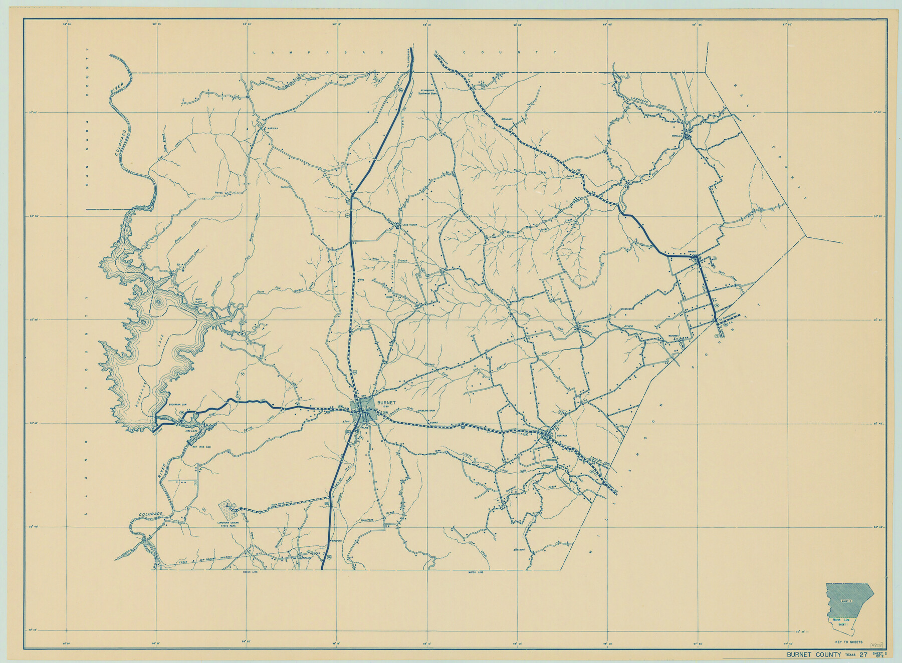
General Highway Map, Burnet County, Texas
- 
                          Map/Doc
79035
 - 
                            Collection
Texas State Library and Archives
 - 
                            Object Dates
1940 (Creation Date)
 - 
                            People and Organizations
Texas State Highway Department (Publisher)
 - 
                            Counties
Burnet
 - 
                            Subjects
County
 - 
                            Height x Width
18.4 x 25.0 inches
46.7 x 63.5 cm
 - 
                            Comments
Prints available courtesy of the Texas State Library and Archives.
More info can be found here: TSLAC Map 04808 
Part of: Texas State Library and Archives
            General Highway Map, Pecos County, Texas


                                            Print $20.00                    
                                    
                General Highway Map, Pecos County, Texas
1961
Size 24.5 x 18.1 inches
                                Map/Doc 79627
            
            General Highway Map, La Salle County, Texas


                                            Print $20.00                    
                                    
                General Highway Map, La Salle County, Texas
1961
Size 18.2 x 24.8 inches
                                Map/Doc 79565
            
            Phelps and Watson's Historical and Military Map of the Border and Southern States


                                            Print $20.00                    
                                    
                Phelps and Watson's Historical and Military Map of the Border and Southern States
1863
Size 25.5 x 36.3 inches
                                Map/Doc 76202
            
            General Highway Map.  Detail of Cities and Towns in Travis County, Texas.  City Map, Austin and vicinity, Travis County, Texas


                                            Print $20.00                    
                                    
                General Highway Map. Detail of Cities and Towns in Travis County, Texas. City Map, Austin and vicinity, Travis County, Texas
1961
Size 18.2 x 24.9 inches
                                Map/Doc 79684
            
            General Highway Map, Harris County, Texas


                                            Print $20.00                    
                                    
                General Highway Map, Harris County, Texas
1961
Size 24.7 x 18.0 inches
                                Map/Doc 79501
            
            General Highway Map, Presidio County, Texas


                                            Print $20.00                    
                                    
                General Highway Map, Presidio County, Texas
1961
Size 24.5 x 18.3 inches
                                Map/Doc 79633
            
            Plat of Corpus Christi


                                            Print $20.00                    
                                    
                Plat of Corpus Christi
1850
Size 18.0 x 27.2 inches
                                Map/Doc 76269
            
            General Highway Map, Goliad County, Texas


                                            Print $20.00                    
                                    
                General Highway Map, Goliad County, Texas
1961
Size 18.2 x 24.7 inches
                                Map/Doc 79481
            
            General Highway Map, Navarro County, Texas


                                            Print $20.00                    
                                    
                General Highway Map, Navarro County, Texas
1961
Size 19.3 x 25.0 inches
                                Map/Doc 79610
            
            Map of Texas and Adjacent Regions in the Eighteenth Century


                                            Print $20.00                    
                                    
                Map of Texas and Adjacent Regions in the Eighteenth Century
1915
Size 19.3 x 23.3 inches
                                Map/Doc 79743
            
            General Highway Map, Borden County, Texas


                                            Print $20.00                    
                                    
                General Highway Map, Borden County, Texas
1961
Size 18.3 x 25.0 inches
                                Map/Doc 79377
            
            General Highway Map, Carson County, Texas


                                            Print $20.00                    
                                    
                General Highway Map, Carson County, Texas
1940
Size 18.5 x 25.1 inches
                                Map/Doc 79041
            You may also like
            Hardin County Sketch File 55


                                            Print $40.00                    
                                             -                         Digital $50.00                                    
                Hardin County Sketch File 55
1924
Size 14.2 x 13.3 inches
                                Map/Doc 25220
            
            Brewster County Rolled Sketch 66


                                            Print $20.00                    
                                             -                         Digital $50.00                                    
                Brewster County Rolled Sketch 66
1946
Size 33.0 x 36.2 inches
                                Map/Doc 61785
            
            [T. & P. Block 43, Township 1N]


                                            Print $20.00                    
                                             -                         Digital $50.00                                    
                [T. & P. Block 43, Township 1N]
Size 23.0 x 17.8 inches
                                Map/Doc 90827
            
            King County Working Sketch 8


                                            Print $20.00                    
                                             -                         Digital $50.00                                    
                King County Working Sketch 8
1955
Size 30.8 x 24.8 inches
                                Map/Doc 70172
            
            Jackson County Sketch File 30


                                            Print $52.00                    
                                             -                         Digital $50.00                                    
                Jackson County Sketch File 30
1944
Size 14.2 x 8.5 inches
                                Map/Doc 27730
            
            Flight Mission No. DCL-7C, Frame 149, Kenedy County


                                            Print $20.00                    
                                             -                         Digital $50.00                                    
                Flight Mission No. DCL-7C, Frame 149, Kenedy County
1943
Size 18.7 x 22.5 inches
                                Map/Doc 86106
            
            Nueces County Rolled Sketch 43


                                            Print $20.00                    
                                             -                         Digital $50.00                                    
                Nueces County Rolled Sketch 43
Size 23.6 x 31.8 inches
                                Map/Doc 6883
            
            General Highway Map.  Detail of Cities and Towns in Harris County, Texas


                                            Print $20.00                    
                                    
                General Highway Map. Detail of Cities and Towns in Harris County, Texas
1961
Size 18.2 x 24.6 inches
                                Map/Doc 79503
            
            Hansford County


                                            Print $20.00                    
                                             -                         Digital $50.00                                    
                Hansford County
1932
Size 39.6 x 38.5 inches
                                Map/Doc 77301
            
            Jeff Davis County Rolled Sketch 43


                                            Print $20.00                    
                                             -                         Digital $50.00                                    
                Jeff Davis County Rolled Sketch 43
2002
Size 24.2 x 24.4 inches
                                Map/Doc 78648
            
            Hutchinson County Rolled Sketch 8


                                            Print $20.00                    
                                             -                         Digital $50.00                                    
                Hutchinson County Rolled Sketch 8
Size 32.0 x 29.1 inches
                                Map/Doc 6279
            
            Donley County Sketch File B9


                                            Print $20.00                    
                                             -                         Digital $50.00                                    
                Donley County Sketch File B9
1920
Size 26.0 x 25.8 inches
                                Map/Doc 11379