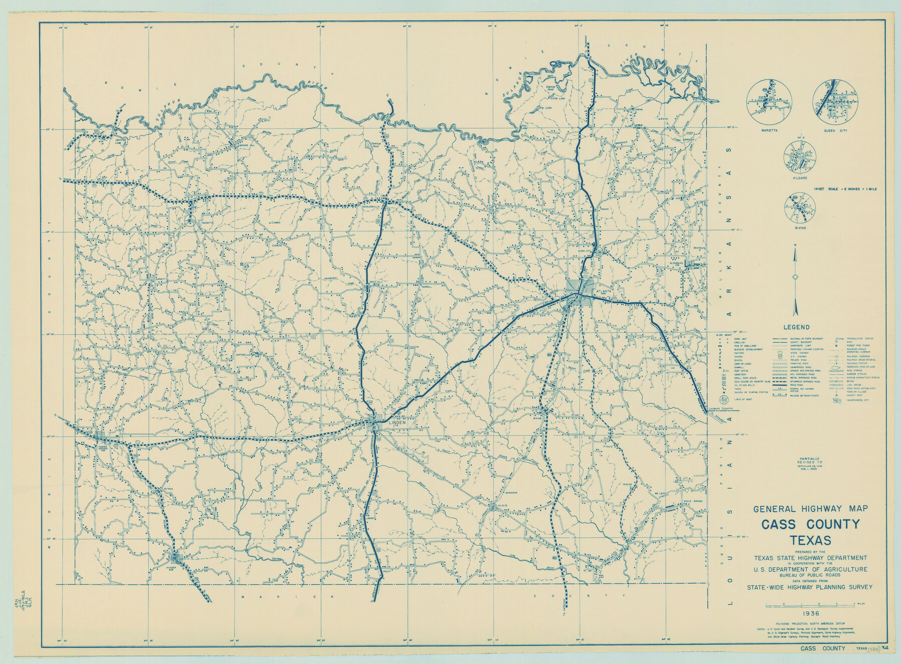
General Highway Map, Cass County, Texas
-
Map/Doc
79042
-
Collection
Texas State Library and Archives
-
Object Dates
1940 (Creation Date)
-
People and Organizations
Texas State Highway Department (Publisher)
-
Counties
Cass
-
Subjects
County
-
Height x Width
18.6 x 25.2 inches
47.2 x 64.0 cm
-
Comments
Prints available courtesy of the Texas State Library and Archives.
More info can be found here: TSLAC Map 04815
Part of: Texas State Library and Archives
Map of the United States to accompany Granger's Southern and Western Texas Guide

Print $20.00
Map of the United States to accompany Granger's Southern and Western Texas Guide
1878
Size 26.4 x 20.4 inches
Map/Doc 76236
General Highway Map, Washington County, Texas

Print $20.00
General Highway Map, Washington County, Texas
1961
Size 18.1 x 24.7 inches
Map/Doc 79703
General Highway Map, Matagorda County, Texas

Print $20.00
General Highway Map, Matagorda County, Texas
1939
Size 24.7 x 18.3 inches
Map/Doc 79187
General Highway Map, Sherman County, Texas

Print $20.00
General Highway Map, Sherman County, Texas
1940
Size 18.2 x 24.9 inches
Map/Doc 79243
General Highway Map, Stephens County, Texas

Print $20.00
General Highway Map, Stephens County, Texas
1961
Size 25.0 x 18.2 inches
Map/Doc 79660
General Highway Map, Dimmit County, La Salle County, Texas

Print $20.00
General Highway Map, Dimmit County, La Salle County, Texas
1940
Size 18.4 x 25.2 inches
Map/Doc 79077
General Highway Map, Hale County, Texas

Print $20.00
General Highway Map, Hale County, Texas
1940
Size 24.8 x 18.4 inches
Map/Doc 79108
Map of the Country Adjacent to the Left Bank of the Rio Grande below Matamoros

Print $20.00
Map of the Country Adjacent to the Left Bank of the Rio Grande below Matamoros
1847
Size 27.8 x 22.8 inches
Map/Doc 79731

Jules A. Appler's Map of San Antonio, Texas and Suburbs

Print $20.00
Jules A. Appler's Map of San Antonio, Texas and Suburbs
1900
Size 43.0 x 29.7 inches
Map/Doc 79303
General Highway Map, Dawson County, Texas

Print $20.00
General Highway Map, Dawson County, Texas
1961
Size 18.0 x 24.5 inches
Map/Doc 79436
General Highway Map, Willacy County, Texas

Print $20.00
General Highway Map, Willacy County, Texas
1940
Size 18.5 x 24.8 inches
Map/Doc 79279
You may also like
[G. C. & S. F. Block S, E. L. & R. R. Block M and B9, D. & W. Block 24]
![91278, [G. C. & S. F. Block S, E. L. & R. R. Block M and B9, D. & W. Block 24], Twichell Survey Records](https://historictexasmaps.com/wmedia_w700/maps/91278-1.tif.jpg)
Print $20.00
- Digital $50.00
[G. C. & S. F. Block S, E. L. & R. R. Block M and B9, D. & W. Block 24]
Size 20.7 x 15.7 inches
Map/Doc 91278
Floyd County Boundary File 4a

Print $40.00
- Digital $50.00
Floyd County Boundary File 4a
Size 12.2 x 35.8 inches
Map/Doc 53496
Travis County Rolled Sketch 33

Print $20.00
- Digital $50.00
Travis County Rolled Sketch 33
Size 22.7 x 32.7 inches
Map/Doc 8034
Edwards County Sketch File 31

Print $6.00
- Digital $50.00
Edwards County Sketch File 31
1926
Size 14.5 x 8.8 inches
Map/Doc 21762
Map of the State of Texas engraved to illustrate Mitchell's school and family geography

Print $20.00
- Digital $50.00
Map of the State of Texas engraved to illustrate Mitchell's school and family geography
1846
Size 11.8 x 9.5 inches
Map/Doc 93498
Bandera County Sketch File 36

Print $6.00
- Digital $50.00
Bandera County Sketch File 36
Size 11.4 x 8.9 inches
Map/Doc 14034
Terrell County Sketch File 6

Print $28.00
- Digital $50.00
Terrell County Sketch File 6
1899
Size 13.0 x 8.5 inches
Map/Doc 37888
Coke County Rolled Sketch 1

Print $20.00
- Digital $50.00
Coke County Rolled Sketch 1
1943
Size 26.9 x 21.6 inches
Map/Doc 5503
Brewster County Sketch File NS-4e

Print $26.00
- Digital $50.00
Brewster County Sketch File NS-4e
1930
Size 8.7 x 11.2 inches
Map/Doc 15965
Dawson County Sketch File 14

Print $4.00
- Digital $50.00
Dawson County Sketch File 14
Size 11.5 x 7.5 inches
Map/Doc 20547
Harris County Rolled Sketch 31

Print $40.00
- Digital $50.00
Harris County Rolled Sketch 31
1893
Size 63.5 x 40.0 inches
Map/Doc 9111
Ochiltree County Working Sketch 3

Print $40.00
- Digital $50.00
Ochiltree County Working Sketch 3
1961
Size 111.8 x 37.5 inches
Map/Doc 71316