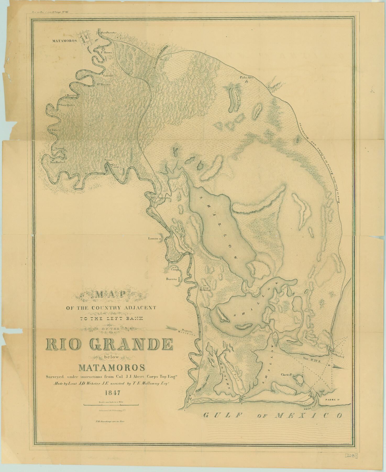
Map of the Country Adjacent to the Left Bank of the Rio Grande below Matamoros
-
Map/Doc
79731
-
Collection
Texas State Library and Archives
-
Object Dates
1847 (Creation Date)
-
People and Organizations
Ackerman's Litho. (Printer)
T.E. Mullorony (Draftsman)
J.J. Abert (Surveyor/Engineer)
J.D. Webster (Draftsman)
-
Subjects
River Surveys Texas Boundaries
-
Height x Width
27.8 x 22.8 inches
70.6 x 57.9 cm
-
Comments
Prints available courtesy of the Texas State Library and Archives.
More info can be found here: TSLAC Map 02287
Part of: Texas State Library and Archives
General Highway Map, Fort Bend County, Texas

Print $20.00
General Highway Map, Fort Bend County, Texas
1961
Size 18.1 x 24.5 inches
Map/Doc 79469

General Highway Map. Detail of Cities and Towns in Nacogdoches County, Texas

Print $20.00
General Highway Map. Detail of Cities and Towns in Nacogdoches County, Texas
1961
Size 19.3 x 25.0 inches
Map/Doc 79608
General Highway Map, McMullen County, Texas

Print $20.00
General Highway Map, McMullen County, Texas
1961
Size 24.7 x 18.3 inches
Map/Doc 79592
United States Including California, Texas, and c.

Print $20.00
United States Including California, Texas, and c.
1861
Size 21.4 x 25.7 inches
Map/Doc 76238
General Highway Map, Falls County, Texas

Print $20.00
General Highway Map, Falls County, Texas
1940
Size 18.5 x 24.7 inches
Map/Doc 79088
General Highway Map, Hill County, Texas

Print $20.00
General Highway Map, Hill County, Texas
1940
Size 25.0 x 18.6 inches
Map/Doc 79129
Section across Valley Bench and Terraces - South Side of Red River - Big Bend Area

Print $20.00
Section across Valley Bench and Terraces - South Side of Red River - Big Bend Area
1921
Size 10.2 x 34.8 inches
Map/Doc 79750
Map of Bexar County Oil Fields

Print $40.00
Map of Bexar County Oil Fields
1919
Size 37.6 x 49.0 inches
Map/Doc 79307
Map of that Portion of the Boundary Between the United States and Mexico from the Pacific Coast to the Junction of the Gila and Colorado Rivers

Print $40.00
Map of that Portion of the Boundary Between the United States and Mexico from the Pacific Coast to the Junction of the Gila and Colorado Rivers
1854
Size 23.9 x 51.4 inches
Map/Doc 79323
A.R. Roessler's Latest Map of the State of Texas Exhibiting Mineral and Agricultural Districts, Post Offices and Mailroutes, Railroads projected and finished, Timber, Prairie, Swamp Lands, etc. etc. etc.

Print $20.00
A.R. Roessler's Latest Map of the State of Texas Exhibiting Mineral and Agricultural Districts, Post Offices and Mailroutes, Railroads projected and finished, Timber, Prairie, Swamp Lands, etc. etc. etc.
1874
Size 39.7 x 46.8 inches
Map/Doc 76254
General Highway Map. Detail of Cities and Towns in Hale County, Texas [Plainview and vicinity]
![79109, General Highway Map. Detail of Cities and Towns in Hale County, Texas [Plainview and vicinity], Texas State Library and Archives](https://historictexasmaps.com/wmedia_w700/maps/79109.tif.jpg)
Print $20.00
General Highway Map. Detail of Cities and Towns in Hale County, Texas [Plainview and vicinity]
1940
Size 25.0 x 18.5 inches
Map/Doc 79109
You may also like
Wharton County Working Sketch 19

Print $20.00
- Digital $50.00
Wharton County Working Sketch 19
1940
Size 21.4 x 23.0 inches
Map/Doc 72483
Galveston County Rolled Sketch 30

Print $20.00
- Digital $50.00
Galveston County Rolled Sketch 30
1979
Size 28.0 x 39.8 inches
Map/Doc 5964
Galveston County NRC Article 33.136 Location Key Sheet

Print $20.00
- Digital $50.00
Galveston County NRC Article 33.136 Location Key Sheet
1995
Size 27.0 x 22.0 inches
Map/Doc 83001
Blanco County Working Sketch 43

Print $20.00
- Digital $50.00
Blanco County Working Sketch 43
1993
Size 42.7 x 26.5 inches
Map/Doc 67403
Flight Mission No. DQN-1K, Frame 34, Calhoun County

Print $20.00
- Digital $50.00
Flight Mission No. DQN-1K, Frame 34, Calhoun County
1953
Size 18.5 x 22.2 inches
Map/Doc 84139
Map of Texas, compiled from surveys on record in the General Land Office of the Republic to the year 1839

Print $20.00
- Digital $50.00
Map of Texas, compiled from surveys on record in the General Land Office of the Republic to the year 1839
1839
Size 33.1 x 25.8 inches
Map/Doc 93986
Brazoria County Sketch File 39

Print $8.00
- Digital $50.00
Brazoria County Sketch File 39
1933
Size 11.3 x 8.8 inches
Map/Doc 15045
Franklin County Boundary File 1

Print $8.00
- Digital $50.00
Franklin County Boundary File 1
Size 12.9 x 8.1 inches
Map/Doc 53569
Nueces County Rolled Sketch 57

Print $48.00
Nueces County Rolled Sketch 57
1979
Size 18.9 x 24.6 inches
Map/Doc 6897
[University Lands in West Texas]
![2422, [University Lands in West Texas], General Map Collection](https://historictexasmaps.com/wmedia_w700/maps/2422.tif.jpg)
Print $20.00
- Digital $50.00
[University Lands in West Texas]
1938
Size 20.3 x 28.1 inches
Map/Doc 2422
Dawson County Sketch File 22

Print $6.00
- Digital $50.00
Dawson County Sketch File 22
1953
Size 11.2 x 8.7 inches
Map/Doc 20572
General Highway Map, Houston County, Texas

Print $20.00
General Highway Map, Houston County, Texas
1940
Size 25.0 x 18.6 inches
Map/Doc 79132