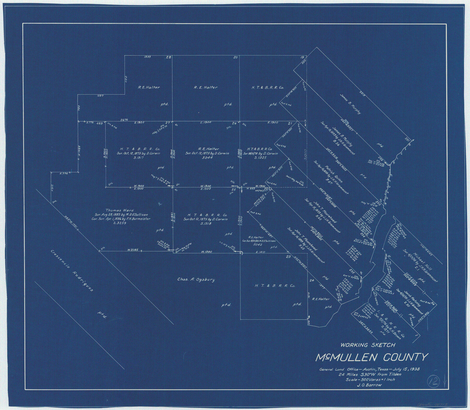
McMullen County Working Sketch 12
-
Map/Doc
70713
-
Collection
General Map Collection
-
Object Dates
7/15/1938 (Creation Date)
-
People and Organizations
J.O. Barrow (Draftsman)
-
Counties
McMullen
-
Subjects
Surveying Working Sketch
-
Height x Width
23.4 x 26.8 inches
59.4 x 68.1 cm
-
Scale
1" = 500 varas
Part of: General Map Collection

Crosby County Sketch File 23

Print $20.00
- Digital $50.00
Crosby County Sketch File 23
1913
Size 15.0 x 27.2 inches
Map/Doc 11254
Texas 1971 Official State Highway Map

Digital $50.00
Texas 1971 Official State Highway Map
Size 28.3 x 36.5 inches
Map/Doc 94316
[Sketch for Mineral Application 24072, San Jacinto River]
![65594, [Sketch for Mineral Application 24072, San Jacinto River], General Map Collection](https://historictexasmaps.com/wmedia_w700/maps/65594.tif.jpg)
Print $20.00
- Digital $50.00
[Sketch for Mineral Application 24072, San Jacinto River]
1929
Size 25.8 x 20.8 inches
Map/Doc 65594
Sutton County Sketch File 6a

Print $6.00
- Digital $50.00
Sutton County Sketch File 6a
1898
Size 7.5 x 6.4 inches
Map/Doc 37362
Foard County Sketch File 12

Print $4.00
- Digital $50.00
Foard County Sketch File 12
1881
Size 11.0 x 8.5 inches
Map/Doc 22814
Layout of the porciones as described in the Visita General of Camargo, 1767

Layout of the porciones as described in the Visita General of Camargo, 1767
2009
Size 11.0 x 8.5 inches
Map/Doc 94041
Yoakum County Sketch File 11

Print $4.00
- Digital $50.00
Yoakum County Sketch File 11
1914
Size 11.3 x 8.9 inches
Map/Doc 40763
El Paso County Working Sketch 32

Print $20.00
- Digital $50.00
El Paso County Working Sketch 32
1971
Size 40.2 x 38.3 inches
Map/Doc 69054
Sutton County Sketch File 42

Print $6.00
- Digital $50.00
Sutton County Sketch File 42
1940
Size 11.2 x 8.8 inches
Map/Doc 37509
Cherokee County Working Sketch 14

Print $40.00
- Digital $50.00
Cherokee County Working Sketch 14
1957
Size 44.9 x 61.1 inches
Map/Doc 67969
Galveston County Rolled Sketch Z61

Print $20.00
- Digital $50.00
Galveston County Rolled Sketch Z61
1934
Size 34.9 x 23.0 inches
Map/Doc 5993
You may also like
Val Verde County Sketch File 22

Print $20.00
- Digital $50.00
Val Verde County Sketch File 22
Size 14.3 x 22.3 inches
Map/Doc 12571
[Blocks RG, I and S]
![92726, [Blocks RG, I and S], Twichell Survey Records](https://historictexasmaps.com/wmedia_w700/maps/92726-1.tif.jpg)
Print $20.00
- Digital $50.00
[Blocks RG, I and S]
Size 36.7 x 37.2 inches
Map/Doc 92726
Flight Mission No. BRA-7M, Frame 190, Jefferson County

Print $20.00
- Digital $50.00
Flight Mission No. BRA-7M, Frame 190, Jefferson County
1953
Size 18.7 x 22.3 inches
Map/Doc 85558
Stonewall County Sketch File AA1

Print $26.00
- Digital $50.00
Stonewall County Sketch File AA1
1916
Size 14.3 x 8.6 inches
Map/Doc 37288
Map of the State of Texas Showing Original Land Districts

Print $20.00
- Digital $50.00
Map of the State of Texas Showing Original Land Districts
1891
Size 43.7 x 43.3 inches
Map/Doc 73598
Presidio County Sketch File 94

Print $6.00
- Digital $50.00
Presidio County Sketch File 94
1955
Size 14.2 x 8.8 inches
Map/Doc 34770
Map of Webb Co.

Print $20.00
- Digital $50.00
Map of Webb Co.
1901
Size 40.4 x 47.1 inches
Map/Doc 16919
Brown County Sketch File 21

Print $40.00
- Digital $50.00
Brown County Sketch File 21
Size 16.4 x 12.8 inches
Map/Doc 11021
Letter from Jesse Grimes Suggesting a Redefinition of the Boundary Between Harris and Montgomery Counties, April 30, 1838

Print $20.00
Letter from Jesse Grimes Suggesting a Redefinition of the Boundary Between Harris and Montgomery Counties, April 30, 1838
2020
Size 15.4 x 21.7 inches
Map/Doc 96381
Culberson County Sketch File 4a

Print $10.00
- Digital $50.00
Culberson County Sketch File 4a
Size 9.2 x 7.9 inches
Map/Doc 20131
Ed Gordon Irrigated Farm NE Quarter Section 14, Block E

Print $20.00
- Digital $50.00
Ed Gordon Irrigated Farm NE Quarter Section 14, Block E
1943
Size 16.0 x 18.6 inches
Map/Doc 92325