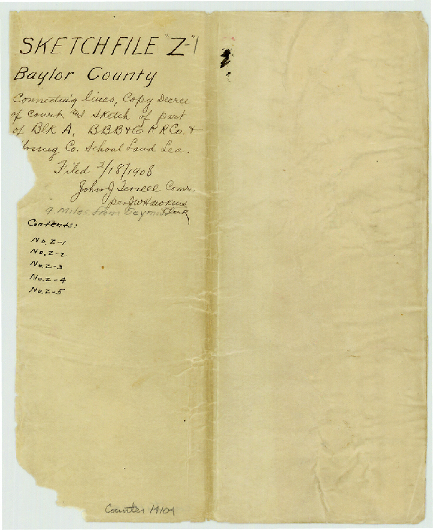
Baylor County Sketch File Z1
[Copy of Decree of Court - Gustave J. Ranger vs. Young County]
-
Map/Doc
14104
-
Collection
General Map Collection
-
Object Dates
1901/6/29 (Creation Date)
1908/2/18 (File Date)
-
Counties
Baylor
-
Subjects
Surveying Sketch File
-
Height x Width
8.8 x 7.2 inches
22.4 x 18.3 cm
-
Medium
paper, manuscript
Part of: General Map Collection
Sketch of coast of Texas, Laguna Madre from Pt. of Rocks to Corpus Christi [and accompanying letter]
![72964, Sketch of coast of Texas, Laguna Madre from Pt. of Rocks to Corpus Christi [and accompanying letter], General Map Collection](https://historictexasmaps.com/wmedia_w700/maps/72964.tif.jpg)
Print $2.00
- Digital $50.00
Sketch of coast of Texas, Laguna Madre from Pt. of Rocks to Corpus Christi [and accompanying letter]
Size 11.2 x 8.8 inches
Map/Doc 72964
Duval County Working Sketch 13

Print $20.00
- Digital $50.00
Duval County Working Sketch 13
1938
Size 27.8 x 32.5 inches
Map/Doc 68726
Blanco County Sketch File 33

Print $4.00
- Digital $50.00
Blanco County Sketch File 33
Size 7.9 x 7.0 inches
Map/Doc 14635
Willacy County Rolled Sketch 2

Print $40.00
- Digital $50.00
Willacy County Rolled Sketch 2
1921
Size 30.7 x 62.9 inches
Map/Doc 10145
Morris County Rolled Sketch 2A

Print $20.00
- Digital $50.00
Morris County Rolled Sketch 2A
Size 24.0 x 18.7 inches
Map/Doc 10286
Jeff Davis County Rolled Sketch T4

Print $20.00
- Digital $50.00
Jeff Davis County Rolled Sketch T4
Size 28.9 x 23.9 inches
Map/Doc 6382
Reeves County Rolled Sketch 6

Print $20.00
- Digital $50.00
Reeves County Rolled Sketch 6
Size 22.6 x 29.0 inches
Map/Doc 7478
Brewster County Sketch File S-2

Print $16.00
- Digital $50.00
Brewster County Sketch File S-2
1910
Size 17.0 x 11.0 inches
Map/Doc 15731
Red River County

Print $20.00
- Digital $50.00
Red River County
1896
Size 24.3 x 21.5 inches
Map/Doc 3977
Terrell County Sketch File 19

Print $6.00
- Digital $50.00
Terrell County Sketch File 19
1910
Size 10.2 x 12.1 inches
Map/Doc 37944
Duval County Sketch File 16

Print $6.00
- Digital $50.00
Duval County Sketch File 16
1875
Size 7.4 x 8.2 inches
Map/Doc 21311
Trinity River, Balltown Sheet/Pilot Grove Creek

Print $20.00
- Digital $50.00
Trinity River, Balltown Sheet/Pilot Grove Creek
1938
Size 40.1 x 33.7 inches
Map/Doc 65196
You may also like

Lynn County Sketch File 17

Print $20.00
- Digital $50.00
Lynn County Sketch File 17
Size 13.2 x 20.9 inches
Map/Doc 12020
Comanche County Sketch File 2

Print $40.00
- Digital $50.00
Comanche County Sketch File 2
1849
Size 16.0 x 12.9 inches
Map/Doc 19053
Webb County Rolled Sketch 73

Print $20.00
- Digital $50.00
Webb County Rolled Sketch 73
1982
Size 33.2 x 17.2 inches
Map/Doc 8221
Carta Hidrografica

Print $20.00
- Digital $50.00
Carta Hidrografica
1897
Size 26.0 x 34.3 inches
Map/Doc 96803
Marion County Working Sketch 13

Print $20.00
- Digital $50.00
Marion County Working Sketch 13
1953
Size 33.2 x 36.3 inches
Map/Doc 70789
[Worksheets related to the Wilson Strickland survey and vicinity]
![91391, [Worksheets related to the Wilson Strickland survey and vicinity], Twichell Survey Records](https://historictexasmaps.com/wmedia_w700/maps/91391-1.tif.jpg)
Print $20.00
- Digital $50.00
[Worksheets related to the Wilson Strickland survey and vicinity]
Size 42.8 x 19.6 inches
Map/Doc 91391
General Highway Map, McLennan County, Texas

Print $20.00
General Highway Map, McLennan County, Texas
1940
Size 18.3 x 24.6 inches
Map/Doc 79191
Kleberg County Rolled Sketch 10-42

Print $20.00
- Digital $50.00
Kleberg County Rolled Sketch 10-42
1952
Size 42.7 x 36.4 inches
Map/Doc 9380
Flight Mission No. BQR-13K, Frame 20, Brazoria County

Print $20.00
- Digital $50.00
Flight Mission No. BQR-13K, Frame 20, Brazoria County
1952
Size 18.9 x 22.5 inches
Map/Doc 84068

General Highway Map, Kaufman County, Texas

Print $20.00
General Highway Map, Kaufman County, Texas
1961
Size 24.9 x 18.1 inches
Map/Doc 79548