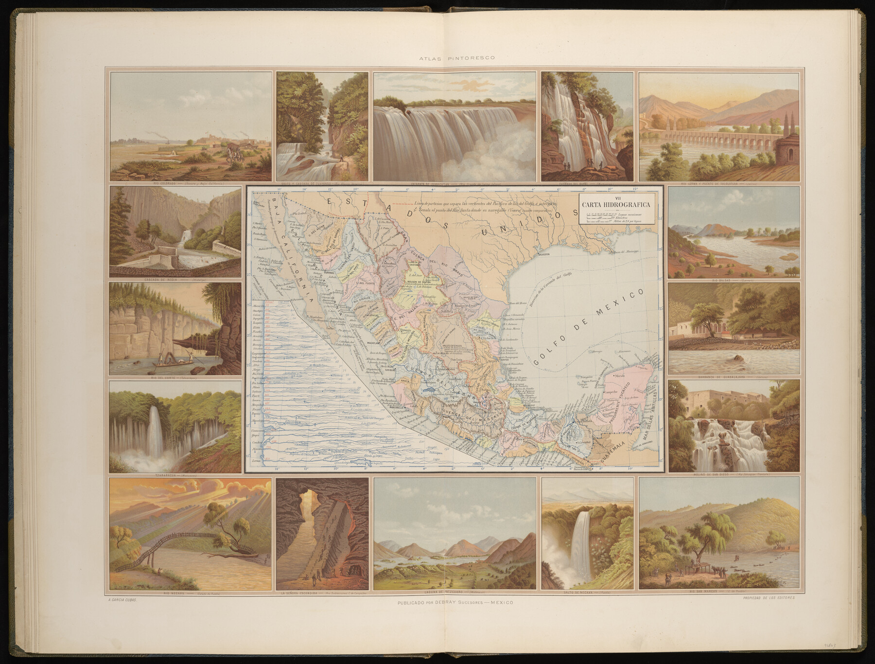
Carta Hidrografica
-
Map/Doc
96803
-
Collection
General Map Collection
-
Object Dates
1897 (Creation Date)
-
People and Organizations
Debray Sucesores (Publisher)
Antonio Garcia Cubas (Cartographer)
-
Subjects
Atlas Mexico
-
Height x Width
26.0 x 34.3 inches
66.0 x 87.1 cm
-
Medium
paper, etching/engraving/lithograph
-
Comments
Map 7 of 13 from "Atlas Pintoresco e Historico de los Estados Unidos Mexicanos" (96796 - PDF)
Related maps
Atlas Pintoresco e Historico de los Estados Unidos Mexicanos

Atlas Pintoresco e Historico de los Estados Unidos Mexicanos
Map/Doc 96796
Part of: General Map Collection
Survey and Location of the Corpus Christi & Rio Grande Railway Under Charter of May 24th 1873

Print $40.00
- Digital $50.00
Survey and Location of the Corpus Christi & Rio Grande Railway Under Charter of May 24th 1873
1874
Size 12.5 x 58.7 inches
Map/Doc 64092
Dawson County Sketch File 7

Print $20.00
- Digital $50.00
Dawson County Sketch File 7
1926
Size 20.0 x 24.6 inches
Map/Doc 11292
Wise County Working Sketch 11

Print $20.00
- Digital $50.00
Wise County Working Sketch 11
1958
Size 18.5 x 30.6 inches
Map/Doc 72625
Current Miscellaneous File 5

Print $8.00
- Digital $50.00
Current Miscellaneous File 5
1946
Size 11.3 x 8.8 inches
Map/Doc 73727
Hemphill County Working Sketch 21

Print $40.00
- Digital $50.00
Hemphill County Working Sketch 21
1973
Size 79.0 x 32.6 inches
Map/Doc 66116

Wilbarger County Working Sketch 1

Print $20.00
- Digital $50.00
Wilbarger County Working Sketch 1
1919
Size 17.6 x 27.9 inches
Map/Doc 72538
Randall County Working Sketch Graphic Index

Print $20.00
- Digital $50.00
Randall County Working Sketch Graphic Index
1958
Size 41.2 x 33.2 inches
Map/Doc 76676
Fisher County Rolled Sketch 5

Print $20.00
- Digital $50.00
Fisher County Rolled Sketch 5
1961
Size 40.3 x 32.5 inches
Map/Doc 10659
Jim Hogg County Working Sketch 8

Print $40.00
- Digital $50.00
Jim Hogg County Working Sketch 8
1966
Size 82.7 x 40.0 inches
Map/Doc 66594
Parker County Sketch File 21

Print $4.00
- Digital $50.00
Parker County Sketch File 21
Size 9.6 x 7.6 inches
Map/Doc 33560
Cameron County Rolled Sketch 19

Print $20.00
- Digital $50.00
Cameron County Rolled Sketch 19
Size 27.1 x 24.3 inches
Map/Doc 5388
You may also like
Matagorda County Rolled Sketch 18

Print $20.00
- Digital $50.00
Matagorda County Rolled Sketch 18
1838
Size 35.7 x 30.8 inches
Map/Doc 6685
El Paso County Working Sketch 43

Print $20.00
- Digital $50.00
El Paso County Working Sketch 43
Size 22.1 x 26.1 inches
Map/Doc 69065
Crockett County Sketch File 84

Print $6.00
- Digital $50.00
Crockett County Sketch File 84
1942
Size 11.4 x 8.9 inches
Map/Doc 19905
Crockett County Working Sketch 65

Print $20.00
- Digital $50.00
Crockett County Working Sketch 65
1957
Size 32.3 x 38.0 inches
Map/Doc 68398
Hutchinson County Working Sketch 28

Print $20.00
- Digital $50.00
Hutchinson County Working Sketch 28
1978
Size 27.1 x 23.1 inches
Map/Doc 66388
Brazoria County Rolled Sketch 34

Print $20.00
- Digital $50.00
Brazoria County Rolled Sketch 34
1944
Size 29.8 x 18.3 inches
Map/Doc 5171
Jeff Davis County Sketch File 4

Print $42.00
- Digital $50.00
Jeff Davis County Sketch File 4
1889
Size 12.5 x 14.7 inches
Map/Doc 27893
Ellis County Boundary File 3

Print $58.00
- Digital $50.00
Ellis County Boundary File 3
Size 14.1 x 122.4 inches
Map/Doc 52950
Borden County Boundary File 2

Print $22.00
- Digital $50.00
Borden County Boundary File 2
Size 13.6 x 8.7 inches
Map/Doc 50614
General Highway Map, Wheeler County, Texas

Print $20.00
General Highway Map, Wheeler County, Texas
1961
Size 18.1 x 24.9 inches
Map/Doc 79708
Chambers County Sketch File 56

Print $7.00
- Digital $50.00
Chambers County Sketch File 56
Size 14.8 x 8.7 inches
Map/Doc 18099