Current Miscellaneous File 98
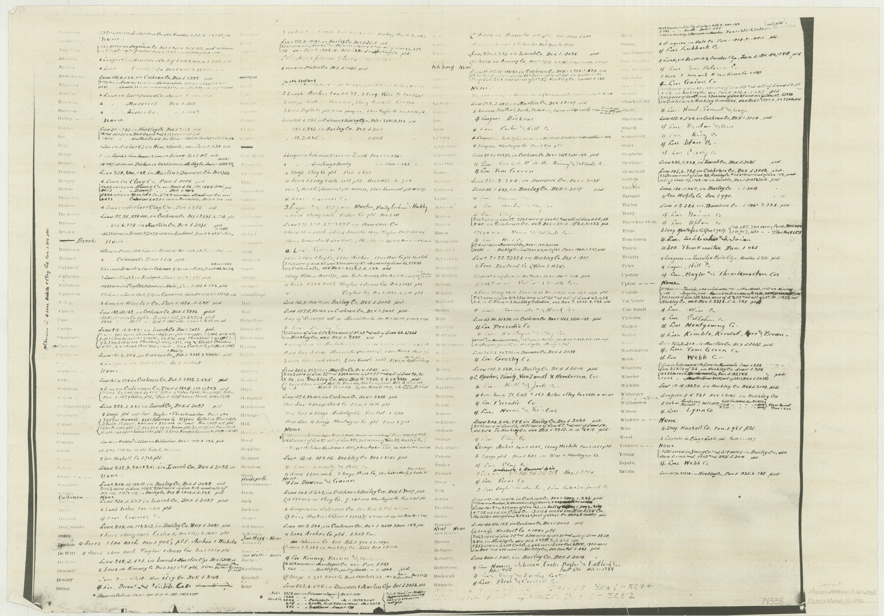
Alphabetical listing of counties with the location of the 4 leagues provided by the Legislature to provide for public education in each county
-
Map/Doc
74338
-
Collection
General Map Collection
-
Object Dates
1996/3/15 (File Date)
-
Subjects
County
-
Height x Width
18.4 x 26.3 inches
46.7 x 66.8 cm
Part of: General Map Collection
Williamson County Working Sketch 12

Print $20.00
- Digital $50.00
Williamson County Working Sketch 12
1977
Size 37.0 x 35.0 inches
Map/Doc 72572
Flight Mission No. DQN-2K, Frame 134, Calhoun County

Print $20.00
- Digital $50.00
Flight Mission No. DQN-2K, Frame 134, Calhoun County
1953
Size 18.8 x 22.4 inches
Map/Doc 84303
Crockett County Rolled Sketch 56

Print $20.00
- Digital $50.00
Crockett County Rolled Sketch 56
1944
Size 24.2 x 31.1 inches
Map/Doc 5599
Hansford County Working Sketch Graphic Index

Print $20.00
- Digital $50.00
Hansford County Working Sketch Graphic Index
1932
Size 39.2 x 38.2 inches
Map/Doc 76565
Flight Mission No. DQN-4K, Frame 7, Calhoun County

Print $20.00
- Digital $50.00
Flight Mission No. DQN-4K, Frame 7, Calhoun County
1953
Size 18.5 x 22.2 inches
Map/Doc 84372

Wilson County Sketch File 3b

Print $22.00
- Digital $50.00
Wilson County Sketch File 3b
Size 7.8 x 11.9 inches
Map/Doc 40402
Hutchinson County Rolled Sketch 44-15

Print $20.00
- Digital $50.00
Hutchinson County Rolled Sketch 44-15
2002
Size 24.0 x 36.0 inches
Map/Doc 77551
Hamilton County Working Sketch 14

Print $20.00
- Digital $50.00
Hamilton County Working Sketch 14
1949
Size 30.1 x 35.4 inches
Map/Doc 63352
Johnson County Rolled Sketch 4

Print $20.00
- Digital $50.00
Johnson County Rolled Sketch 4
Size 24.8 x 36.0 inches
Map/Doc 94047
Moore County Rolled Sketch 3

Print $20.00
- Digital $50.00
Moore County Rolled Sketch 3
Size 12.3 x 15.3 inches
Map/Doc 6823
Brooks County Working Sketch 2

Print $3.00
- Digital $50.00
Brooks County Working Sketch 2
Size 10.0 x 16.2 inches
Map/Doc 67786
You may also like
[G. B. & C. N. G. Blocks K3-K8]
![90537, [G. B. & C. N. G. Blocks K3-K8], Twichell Survey Records](https://historictexasmaps.com/wmedia_w700/maps/90537-1.tif.jpg)
Print $3.00
- Digital $50.00
[G. B. & C. N. G. Blocks K3-K8]
Size 11.4 x 13.7 inches
Map/Doc 90537
Township 5 South Range 13 West, South Western District, Louisiana

Print $20.00
- Digital $50.00
Township 5 South Range 13 West, South Western District, Louisiana
1879
Size 19.3 x 24.8 inches
Map/Doc 65885
Terry County Rolled Sketch 4

Print $20.00
- Digital $50.00
Terry County Rolled Sketch 4
Size 38.7 x 36.8 inches
Map/Doc 9994
Denton County Working Sketch 14

Print $40.00
- Digital $50.00
Denton County Working Sketch 14
1962
Size 60.5 x 36.3 inches
Map/Doc 68619
Colorado County Working Sketch 28

Print $20.00
- Digital $50.00
Colorado County Working Sketch 28
1979
Size 33.5 x 24.3 inches
Map/Doc 68128

Jeff Davis County Sketch File 33

Print $40.00
- Digital $50.00
Jeff Davis County Sketch File 33
1944
Size 48.2 x 26.0 inches
Map/Doc 10507
Montgomery County Working Sketch 74

Print $20.00
- Digital $50.00
Montgomery County Working Sketch 74
1981
Size 37.6 x 45.6 inches
Map/Doc 71181
Swisher County Sketch File 2

Print $8.00
- Digital $50.00
Swisher County Sketch File 2
1891
Size 14.3 x 8.6 inches
Map/Doc 37574
Map of Yoakum County

Print $20.00
- Digital $50.00
Map of Yoakum County
1902
Size 47.2 x 35.3 inches
Map/Doc 16934
Flight Mission No. CRE-2R, Frame 168, Jackson County

Print $20.00
- Digital $50.00
Flight Mission No. CRE-2R, Frame 168, Jackson County
1956
Size 18.5 x 22.3 inches
Map/Doc 85378
