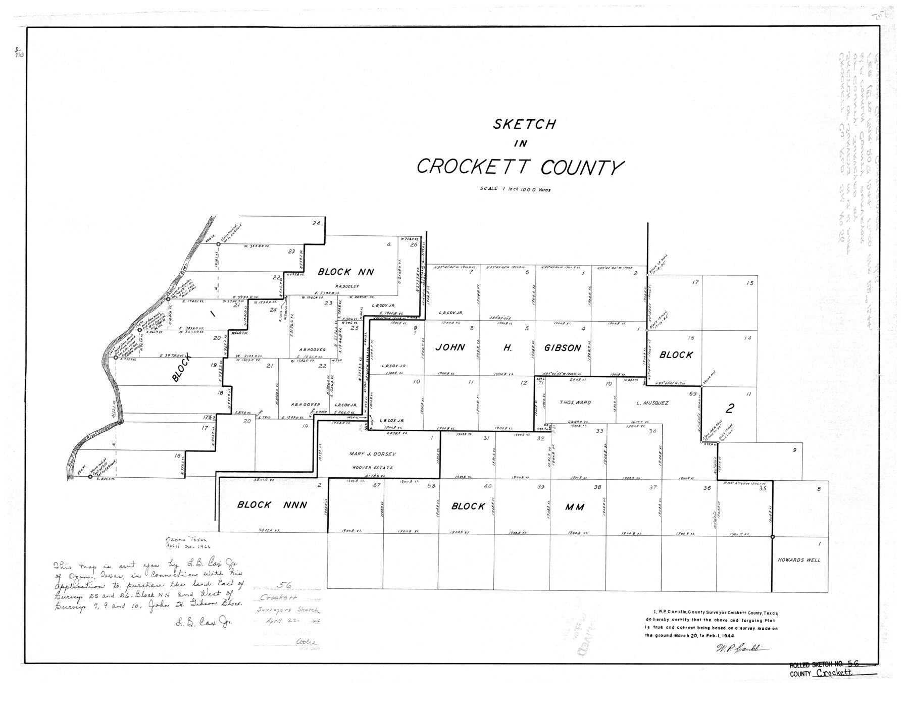
Crockett County Rolled Sketch 56
Sketch in Crockett County
-
Map/Doc
5599
-
Collection
General Map Collection
-
Object Dates
1944/4/20 (Creation Date)
1944/4/22 (File Date)
1944/2/1 (Survey Date)
-
People and Organizations
W.P. Conklin (Surveyor/Engineer)
-
Counties
Crockett
-
Subjects
Surveying Rolled Sketch
-
Height x Width
24.2 x 31.1 inches
61.5 x 79.0 cm
-
Scale
1" = 1000 varas
Part of: General Map Collection
Webb County Sketch File 11a

Print $4.00
- Digital $50.00
Webb County Sketch File 11a
1883
Size 11.2 x 8.7 inches
Map/Doc 39779
Map of Georgia, Florida, Alabama, Mississippi and Tennessee engraved to illustrate Mitchell's new intermediate geography

Print $20.00
- Digital $50.00
Map of Georgia, Florida, Alabama, Mississippi and Tennessee engraved to illustrate Mitchell's new intermediate geography
1885
Size 12.2 x 9.0 inches
Map/Doc 93518
Map of Trinity Co.

Print $20.00
- Digital $50.00
Map of Trinity Co.
1896
Size 40.7 x 39.1 inches
Map/Doc 63079
Flight Mission No. DAG-21K, Frame 107, Matagorda County

Print $20.00
- Digital $50.00
Flight Mission No. DAG-21K, Frame 107, Matagorda County
1952
Size 18.6 x 22.4 inches
Map/Doc 86435
Dickens County Sketch File 24

Print $20.00
- Digital $50.00
Dickens County Sketch File 24
1914
Size 20.0 x 16.1 inches
Map/Doc 11325
Jasper County Sketch File 12a

Print $16.00
- Digital $50.00
Jasper County Sketch File 12a
1881
Size 13.0 x 8.4 inches
Map/Doc 27794
Mason County Boundary File 5a

Print $40.00
- Digital $50.00
Mason County Boundary File 5a
Size 18.0 x 32.6 inches
Map/Doc 56872
Val Verde County Working Sketch 79

Print $40.00
- Digital $50.00
Val Verde County Working Sketch 79
1973
Size 51.0 x 32.4 inches
Map/Doc 72214
Lipscomb County Boundary File 14a

Print $4.00
- Digital $50.00
Lipscomb County Boundary File 14a
Size 11.3 x 8.7 inches
Map/Doc 56368
Cameron County Sketch File 17

Print $24.00
- Digital $50.00
Cameron County Sketch File 17
2009
Size 11.0 x 8.5 inches
Map/Doc 95191
Aransas County NRC Article 33.136 Sketch 17

Print $206.00
- Digital $50.00
Aransas County NRC Article 33.136 Sketch 17
2019
Size 22.4 x 35.8 inches
Map/Doc 96475
Baylor County Sketch File 32

Print $10.00
- Digital $50.00
Baylor County Sketch File 32
Size 10.2 x 8.2 inches
Map/Doc 14238
You may also like
Louisiana and Texas Intracoastal Waterway, Section 7, Galveston Bay to Brazos River and Section 8, Brazos River to Matagorda Bay

Print $20.00
- Digital $50.00
Louisiana and Texas Intracoastal Waterway, Section 7, Galveston Bay to Brazos River and Section 8, Brazos River to Matagorda Bay
1937
Size 30.7 x 42.7 inches
Map/Doc 73064
Loving County Rolled Sketch 5

Print $40.00
- Digital $50.00
Loving County Rolled Sketch 5
1952
Size 146.0 x 14.2 inches
Map/Doc 9467
Flight Mission No. DCL-6C, Frame 178, Kenedy County

Print $20.00
- Digital $50.00
Flight Mission No. DCL-6C, Frame 178, Kenedy County
1943
Size 18.7 x 22.4 inches
Map/Doc 85990
Amended and Corrected Map of Adrian and Adrian Heights Addition Situated in Oldham County, Texas on Sections 14, 15, 38, 39 and 16 Respectively

Print $20.00
- Digital $50.00
Amended and Corrected Map of Adrian and Adrian Heights Addition Situated in Oldham County, Texas on Sections 14, 15, 38, 39 and 16 Respectively
Size 31.5 x 43.5 inches
Map/Doc 89801
Flight Mission No. CUG-3P, Frame 172, Kleberg County

Print $20.00
- Digital $50.00
Flight Mission No. CUG-3P, Frame 172, Kleberg County
1956
Size 18.6 x 22.2 inches
Map/Doc 86292
Mills County Rolled Sketch 5

Print $20.00
- Digital $50.00
Mills County Rolled Sketch 5
2001
Size 27.1 x 21.6 inches
Map/Doc 6783
Mud Creek in Nacogdoches District

Print $2.00
- Digital $50.00
Mud Creek in Nacogdoches District
1846
Size 10.7 x 7.8 inches
Map/Doc 345
Gray County Working Sketch 1

Print $40.00
- Digital $50.00
Gray County Working Sketch 1
Size 121.0 x 38.8 inches
Map/Doc 63232
Real County Working Sketch 15

Print $20.00
- Digital $50.00
Real County Working Sketch 15
1940
Size 17.7 x 22.3 inches
Map/Doc 71907
Crockett County Sketch File 88

Print $3.00
- Digital $50.00
Crockett County Sketch File 88
1958
Size 19.3 x 15.8 inches
Map/Doc 11237
Reagan County Working Sketch 9

Print $20.00
- Digital $50.00
Reagan County Working Sketch 9
1939
Size 12.4 x 24.2 inches
Map/Doc 71849
Ellwood Farms Subdivision Number 2 of the Spade Ranch

Print $20.00
- Digital $50.00
Ellwood Farms Subdivision Number 2 of the Spade Ranch
Size 21.9 x 31.4 inches
Map/Doc 90986