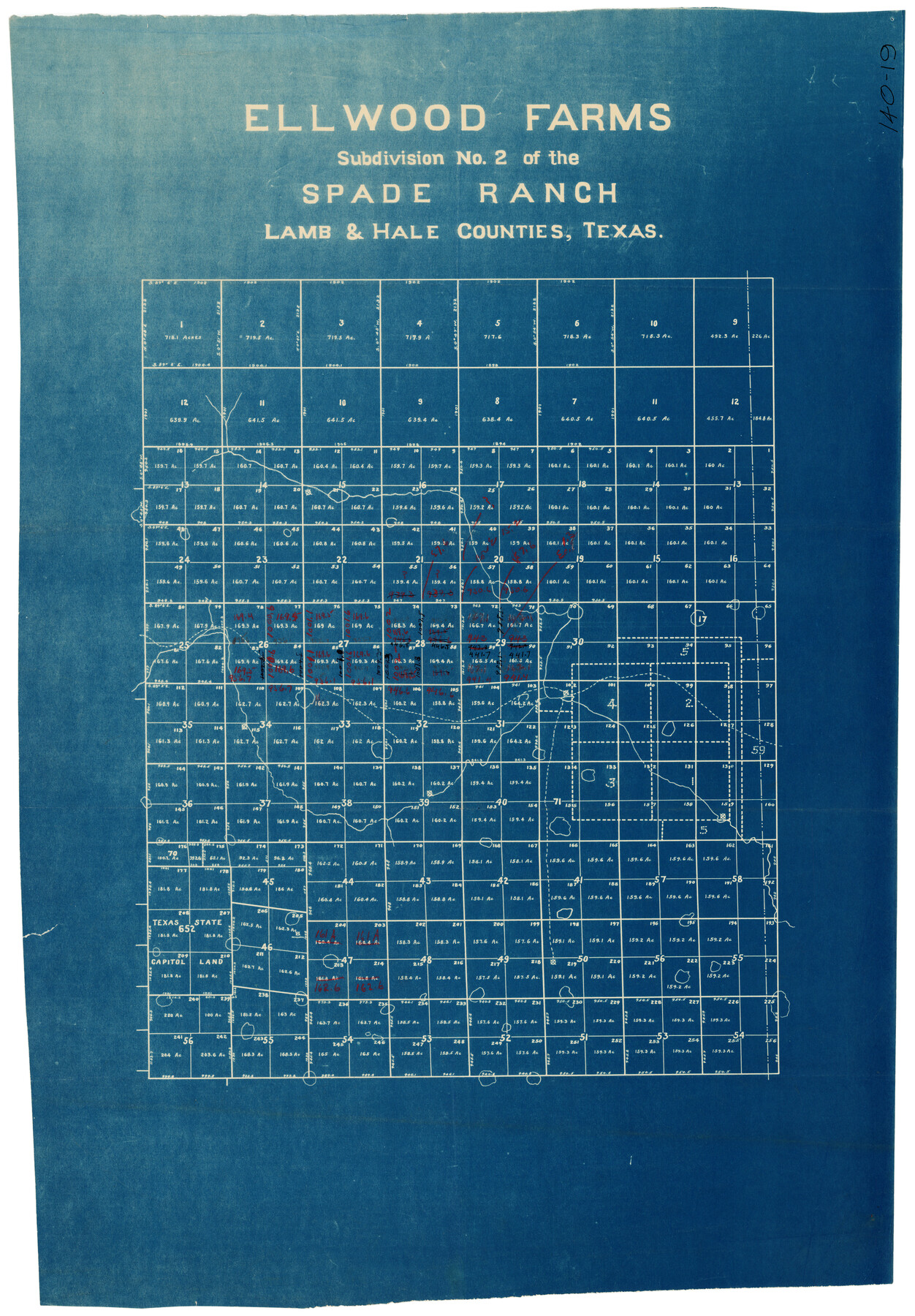
Ellwood Farms Subdivision Number 2 of the Spade Ranch
140-19
-
Map/Doc
90986
-
Collection
Twichell Survey Records
-
Counties
Lamb Hale
-
Height x Width
21.9 x 31.4 inches
55.6 x 79.8 cm
Part of: Twichell Survey Records
[G. B. & C. Blocks K3 and K4]
![90512, [G. B. & C. Blocks K3 and K4], Twichell Survey Records](https://historictexasmaps.com/wmedia_w700/maps/90512-1.tif.jpg)
Print $20.00
- Digital $50.00
[G. B. & C. Blocks K3 and K4]
Size 14.0 x 14.5 inches
Map/Doc 90512
[Part of T. & N. O. RR. Co Block 2 and area around Jasper Hays survey]
![90850, [Part of T. & N. O. RR. Co Block 2 and area around Jasper Hays survey], Twichell Survey Records](https://historictexasmaps.com/wmedia_w700/maps/90850-2.tif.jpg)
Print $20.00
- Digital $50.00
[Part of T. & N. O. RR. Co Block 2 and area around Jasper Hays survey]
1907
Size 13.3 x 28.4 inches
Map/Doc 90850

Seminole Cemetery, Gaines County, Texas

Print $20.00
- Digital $50.00
Seminole Cemetery, Gaines County, Texas
Size 29.2 x 31.7 inches
Map/Doc 92690
[H. & T.C. Blocks 46, 47]
![89927, [H. & T.C. Blocks 46, 47], Twichell Survey Records](https://historictexasmaps.com/wmedia_w700/maps/89927-1.tif.jpg)
Print $20.00
- Digital $50.00
[H. & T.C. Blocks 46, 47]
Size 37.3 x 46.6 inches
Map/Doc 89927
Sketch for Blocks D6, D7, D8 situated in Val Verde County, Texas

Print $40.00
- Digital $50.00
Sketch for Blocks D6, D7, D8 situated in Val Verde County, Texas
1937
Size 100.1 x 40.1 inches
Map/Doc 93164
[Corner of Blocks H1, K5, Z3, S, and Block 8]
![91470, [Corner of Blocks H1, K5, Z3, S, and Block 8], Twichell Survey Records](https://historictexasmaps.com/wmedia_w700/maps/91470-1.tif.jpg)
Print $3.00
- Digital $50.00
[Corner of Blocks H1, K5, Z3, S, and Block 8]
Size 11.9 x 14.6 inches
Map/Doc 91470
C.C. Slaughter's Running Water Ranch situated in Hale and Lamb Counties

Print $40.00
- Digital $50.00
C.C. Slaughter's Running Water Ranch situated in Hale and Lamb Counties
Size 38.1 x 55.5 inches
Map/Doc 89924
Block 34, Township 5 South

Print $3.00
- Digital $50.00
Block 34, Township 5 South
1876
Size 9.6 x 9.6 inches
Map/Doc 90752
Seagraves Chamber of Commerce Subdivision of Northeast Quarter of Southeast Quarter of Section 9, Block C-34, Gaines County, Texas

Print $20.00
- Digital $50.00
Seagraves Chamber of Commerce Subdivision of Northeast Quarter of Southeast Quarter of Section 9, Block C-34, Gaines County, Texas
1955
Size 16.7 x 18.2 inches
Map/Doc 92684
[G. C. & S. F. Railroad Company Block H2, Town of Adrian, and Vicinity]
![91439, [G. C. & S. F. Railroad Company Block H2, Town of Adrian, and Vicinity], Twichell Survey Records](https://historictexasmaps.com/wmedia_w700/maps/91439-1.tif.jpg)
Print $20.00
- Digital $50.00
[G. C. & S. F. Railroad Company Block H2, Town of Adrian, and Vicinity]
Size 24.4 x 15.8 inches
Map/Doc 91439
Plat of Section No. 44, Blk. No. 4, T. & P. RR. Co. showing subdivisions of same with 3.1 acre survey made for W. D. Twichell

Print $2.00
- Digital $50.00
Plat of Section No. 44, Blk. No. 4, T. & P. RR. Co. showing subdivisions of same with 3.1 acre survey made for W. D. Twichell
1919
Size 8.9 x 13.3 inches
Map/Doc 91908
You may also like
Flight Mission No. CGI-3N, Frame 169, Cameron County

Print $20.00
- Digital $50.00
Flight Mission No. CGI-3N, Frame 169, Cameron County
1954
Size 18.6 x 22.3 inches
Map/Doc 84633
Nueces County Rolled Sketch 51A

Print $20.00
- Digital $50.00
Nueces County Rolled Sketch 51A
1978
Size 27.6 x 39.1 inches
Map/Doc 6890
Harrison County Sketch File 17

Print $4.00
- Digital $50.00
Harrison County Sketch File 17
1874
Size 8.8 x 10.5 inches
Map/Doc 26059

Southern Part of Laguna Madre

Print $20.00
- Digital $50.00
Southern Part of Laguna Madre
1952
Size 44.7 x 35.2 inches
Map/Doc 73537
Archer County Sketch File 29

Print $80.00
- Digital $50.00
Archer County Sketch File 29
1888
Size 21.8 x 16.5 inches
Map/Doc 10836
Nueces County Sketch File 56

Print $113.00
- Digital $50.00
Nueces County Sketch File 56
1973
Size 10.1 x 9.3 inches
Map/Doc 32874
Pecos County Working Sketch 108

Print $40.00
- Digital $50.00
Pecos County Working Sketch 108
1971
Size 43.5 x 56.3 inches
Map/Doc 71581
Bandera County Working Sketch 46

Print $20.00
- Digital $50.00
Bandera County Working Sketch 46
1981
Size 28.0 x 37.4 inches
Map/Doc 67642
Gaines County Rolled Sketch 7

Print $40.00
- Digital $50.00
Gaines County Rolled Sketch 7
1915
Size 35.7 x 54.0 inches
Map/Doc 9014
Chambers County NRC Article 33.136 Sketch 4

Print $48.00
- Digital $50.00
Chambers County NRC Article 33.136 Sketch 4
2003
Size 18.2 x 24.3 inches
Map/Doc 78569
Capitol Lands survey by J. T. Munson

Print $20.00
- Digital $50.00
Capitol Lands survey by J. T. Munson
Size 25.6 x 21.0 inches
Map/Doc 90575