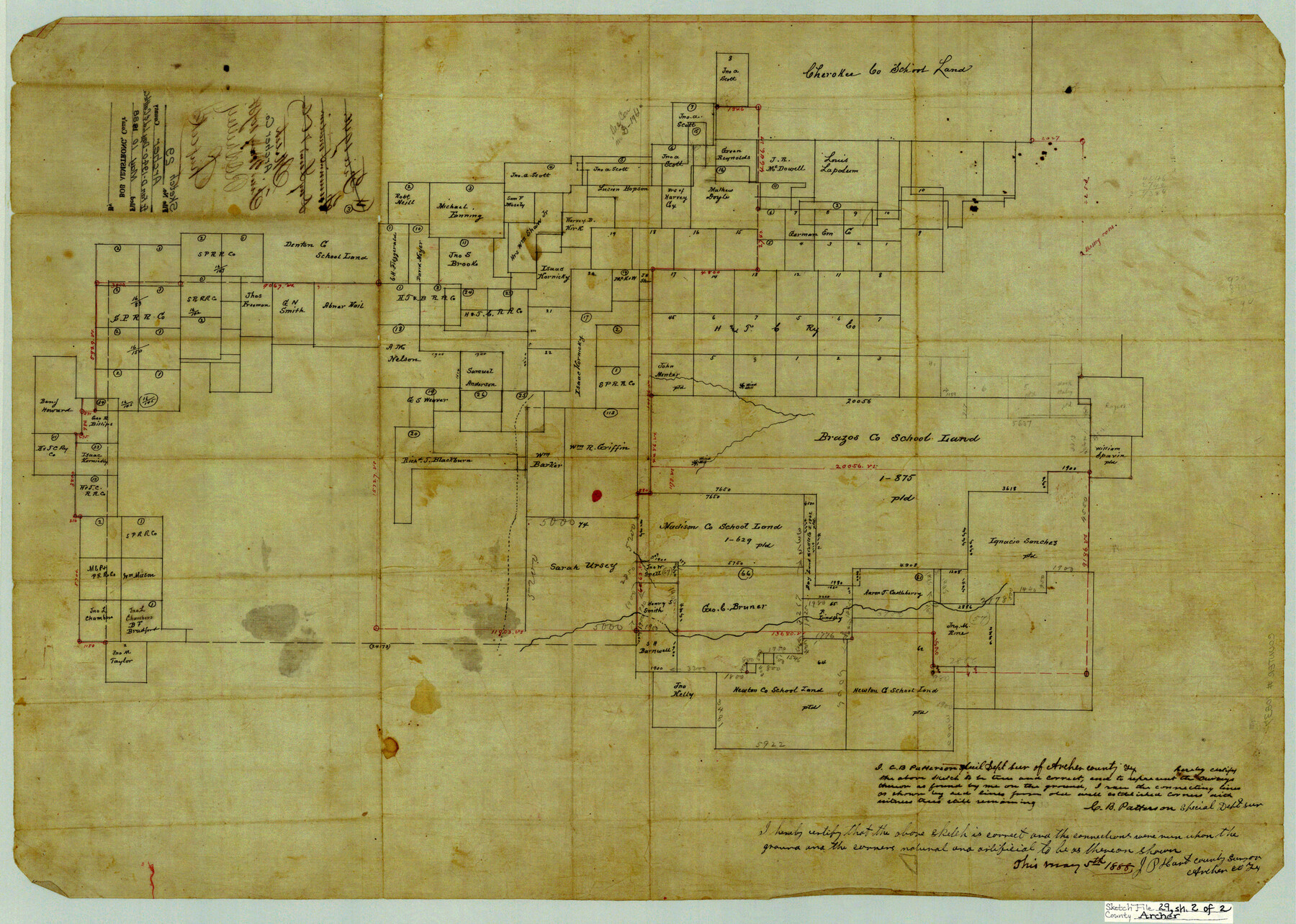
Archer County Sketch File 29
[Multiple sketches in Archer County]
-
Map/Doc
10836
-
Collection
General Map Collection
-
Object Dates
1888/5/5 (Creation Date)
1888/5/10 (File Date)
-
People and Organizations
T.M. Cecil (Surveyor/Engineer)
C.B. Patterson (Surveyor/Engineer)
-
Counties
Archer
-
Subjects
Surveying Sketch File
-
Height x Width
21.8 x 16.5 inches
55.4 x 41.9 cm
-
Medium
linen, manuscript
-
Comments
Sketches transferred from Fannin B-1940.
Part of: General Map Collection
Gaines County Boundary File 2

Print $42.00
- Digital $50.00
Gaines County Boundary File 2
Size 11.5 x 52.3 inches
Map/Doc 53652
Kerr County Working Sketch 6

Print $20.00
- Digital $50.00
Kerr County Working Sketch 6
1947
Size 32.8 x 26.3 inches
Map/Doc 70037
Map of Stephens County

Print $20.00
- Digital $50.00
Map of Stephens County
1897
Size 43.2 x 37.6 inches
Map/Doc 16818
McLennan County

Print $20.00
- Digital $50.00
McLennan County
1946
Size 42.5 x 45.8 inches
Map/Doc 73235
Wichita County Sketch File 28

Print $22.00
- Digital $50.00
Wichita County Sketch File 28
1929
Size 12.5 x 17.0 inches
Map/Doc 40130
Runnels County Rolled Sketch 32

Print $20.00
- Digital $50.00
Runnels County Rolled Sketch 32
Size 34.9 x 44.5 inches
Map/Doc 9868
Zapata County Working Sketch 5

Print $20.00
- Digital $50.00
Zapata County Working Sketch 5
1940
Size 23.4 x 18.3 inches
Map/Doc 62056
Brazoria County Sketch File 6a

Print $40.00
- Digital $50.00
Brazoria County Sketch File 6a
1862
Size 17.6 x 12.6 inches
Map/Doc 10949
[Sketch of Oyster Bay, Bastrop Bay, Chocolate Bay, and West Bay]
![3103, [Sketch of Oyster Bay, Bastrop Bay, Chocolate Bay, and West Bay], General Map Collection](https://historictexasmaps.com/wmedia_w700/maps/3103.tif.jpg)
Print $20.00
- Digital $50.00
[Sketch of Oyster Bay, Bastrop Bay, Chocolate Bay, and West Bay]
1871
Size 6.0 x 23.9 inches
Map/Doc 3103
La Salle County Sketch File 5

Print $2.00
- Digital $50.00
La Salle County Sketch File 5
Size 6.9 x 8.9 inches
Map/Doc 29452
DeWitt County Sketch File 2

Print $40.00
- Digital $50.00
DeWitt County Sketch File 2
1868
Size 13.0 x 12.2 inches
Map/Doc 20799
Flight Mission No. CUG-1P, Frame 106, Kleberg County

Print $20.00
- Digital $50.00
Flight Mission No. CUG-1P, Frame 106, Kleberg County
1956
Size 18.8 x 22.3 inches
Map/Doc 86156
You may also like

Palo Pinto County Boundary File 4

Print $17.00
- Digital $50.00
Palo Pinto County Boundary File 4
Size 9.0 x 8.4 inches
Map/Doc 57811
Flight Mission No. CUG-1P, Frame 47, Kleberg County

Print $20.00
- Digital $50.00
Flight Mission No. CUG-1P, Frame 47, Kleberg County
1956
Size 18.7 x 22.4 inches
Map/Doc 86125
Nueces County Sketch File 54

Print $4.00
- Digital $50.00
Nueces County Sketch File 54
1856
Size 12.7 x 8.1 inches
Map/Doc 32865
Plat showing proposed counties to be taken from Zapata, Starr & Hidalgo Counties

Print $20.00
- Digital $50.00
Plat showing proposed counties to be taken from Zapata, Starr & Hidalgo Counties
1911
Size 24.8 x 27.8 inches
Map/Doc 2660
Cochran County Rolled Sketch A

Print $40.00
- Digital $50.00
Cochran County Rolled Sketch A
Size 28.5 x 55.3 inches
Map/Doc 8604
Louisiana and Texas Intracoastal Waterway

Print $20.00
- Digital $50.00
Louisiana and Texas Intracoastal Waterway
1929
Size 13.6 x 19.6 inches
Map/Doc 83342
Archer County

Print $20.00
- Digital $50.00
Archer County
1926
Size 43.7 x 37.9 inches
Map/Doc 95419
Young County Sketch File 16

Print $4.00
- Digital $50.00
Young County Sketch File 16
1896
Size 10.3 x 8.5 inches
Map/Doc 40880
Edwards County Working Sketch 5

Print $20.00
- Digital $50.00
Edwards County Working Sketch 5
1907
Size 14.9 x 23.4 inches
Map/Doc 68881
Matagorda County Rolled Sketch 16

Print $20.00
- Digital $50.00
Matagorda County Rolled Sketch 16
Size 25.7 x 41.6 inches
Map/Doc 7591
Bowie County Sketch File 8

Print $42.00
- Digital $50.00
Bowie County Sketch File 8
1927
Size 8.9 x 3.8 inches
Map/Doc 14872