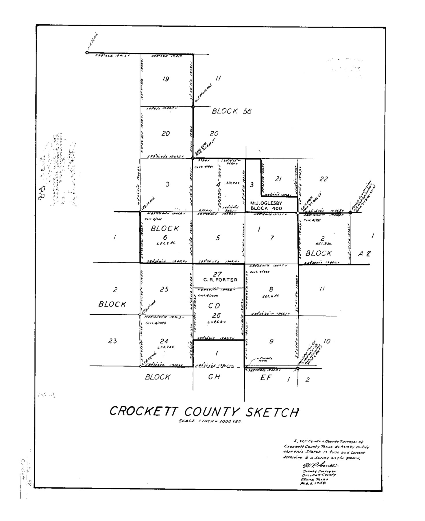
Crockett County Sketch File 88
Sec. 2 - Blk. A-2, Sec. 24 & 25, Blk. CD and Sec. 4, 6 and 8, Blk. 1
-
Map/Doc
11237
-
Collection
General Map Collection
-
Object Dates
1958/2/6 (Creation Date)
1958/2/13 (File Date)
-
People and Organizations
W.P. Conklin (Surveyor/Engineer)
-
Counties
Crockett
-
Subjects
Surveying Sketch File
-
Height x Width
19.3 x 15.8 inches
49.0 x 40.1 cm
-
Medium
paper, photocopy
-
Scale
1:1000
Part of: General Map Collection
Palo Pinto County Working Sketch 3

Print $20.00
- Digital $50.00
Palo Pinto County Working Sketch 3
1906
Map/Doc 71386
Calhoun County Rolled Sketch 35

Print $20.00
- Digital $50.00
Calhoun County Rolled Sketch 35
1929
Size 36.5 x 26.6 inches
Map/Doc 5511
Presidio County Rolled Sketch S1

Print $20.00
- Digital $50.00
Presidio County Rolled Sketch S1
Size 13.3 x 18.8 inches
Map/Doc 7414
Hidalgo County Rolled Sketch 9

Print $20.00
- Digital $50.00
Hidalgo County Rolled Sketch 9
1906
Size 18.9 x 24.8 inches
Map/Doc 6210
Map of Wichita County Young Land District, formerly Fannin Land District

Print $20.00
- Digital $50.00
Map of Wichita County Young Land District, formerly Fannin Land District
1859
Size 22.4 x 20.5 inches
Map/Doc 4141
Hood County Working Sketch 11

Print $20.00
- Digital $50.00
Hood County Working Sketch 11
1976
Size 19.7 x 25.2 inches
Map/Doc 66205

Harris County State Real Property Sketch 5

Print $20.00
- Digital $50.00
Harris County State Real Property Sketch 5
2003
Size 24.5 x 36.0 inches
Map/Doc 82007
Foard County Sketch File 13

Print $6.00
- Digital $50.00
Foard County Sketch File 13
1885
Size 13.0 x 8.5 inches
Map/Doc 22816
Midland County

Print $20.00
- Digital $50.00
Midland County
1930
Size 39.8 x 33.1 inches
Map/Doc 77372
Orange County Working Sketch 41

Print $20.00
- Digital $50.00
Orange County Working Sketch 41
1979
Size 28.0 x 18.2 inches
Map/Doc 71373
Bee County Sketch File 32

Print $4.00
- Digital $50.00
Bee County Sketch File 32
Size 7.9 x 12.6 inches
Map/Doc 14347
You may also like
Hemphill County Rolled Sketch 17

Print $20.00
- Digital $50.00
Hemphill County Rolled Sketch 17
1965
Size 29.2 x 40.1 inches
Map/Doc 6198
Red River, Kelsey Sheet, Upshur County

Print $4.00
- Digital $50.00
Red River, Kelsey Sheet, Upshur County
1933
Size 21.1 x 24.2 inches
Map/Doc 65056
Natural provinces : [Texas].
![93576, Natural provinces : [Texas]., Library of Congress](https://historictexasmaps.com/wmedia_w700/maps/93576.tif.jpg)
Print $20.00
Natural provinces : [Texas].
1899
Size 14.2 x 15.4 inches
Map/Doc 93576
Right of Way & Track Map Houston & Brazos Valley Ry. operated by Houston & Brazos Valley Ry. Co., Hoskins Mound Branch

Print $40.00
- Digital $50.00
Right of Way & Track Map Houston & Brazos Valley Ry. operated by Houston & Brazos Valley Ry. Co., Hoskins Mound Branch
1924
Size 25.0 x 56.6 inches
Map/Doc 64610
Parker County Working Sketch 3

Print $20.00
- Digital $50.00
Parker County Working Sketch 3
1941
Map/Doc 71453
Flight Mission No. DQN-7K, Frame 7, Calhoun County

Print $20.00
- Digital $50.00
Flight Mission No. DQN-7K, Frame 7, Calhoun County
1953
Size 18.5 x 22.2 inches
Map/Doc 84458
[T. & P. Blocks 32-36, Townships 3N, 4N and 5N]
![90630, [T. & P. Blocks 32-36, Townships 3N, 4N and 5N], Twichell Survey Records](https://historictexasmaps.com/wmedia_w700/maps/90630.tif.jpg)
Print $20.00
- Digital $50.00
[T. & P. Blocks 32-36, Townships 3N, 4N and 5N]
Size 35.5 x 24.6 inches
Map/Doc 90630
Map of Kaufman and Rockwall Counties, Texas

Print $20.00
Map of Kaufman and Rockwall Counties, Texas
1878
Size 23.4 x 17.3 inches
Map/Doc 88963
Yoakum County Rolled Sketch 1

Print $20.00
- Digital $50.00
Yoakum County Rolled Sketch 1
1939
Size 40.5 x 37.5 inches
Map/Doc 10162
Atascosa County Sketch File 22

Print $6.00
- Digital $50.00
Atascosa County Sketch File 22
Size 14.2 x 8.6 inches
Map/Doc 13789
Mason County Sketch File 4

Print $6.00
- Digital $50.00
Mason County Sketch File 4
1875
Size 12.9 x 8.0 inches
Map/Doc 30684
Kimble County Working Sketch 86

Print $20.00
- Digital $50.00
Kimble County Working Sketch 86
1973
Size 39.3 x 25.6 inches
Map/Doc 70154