Harris County State Real Property Sketch 5
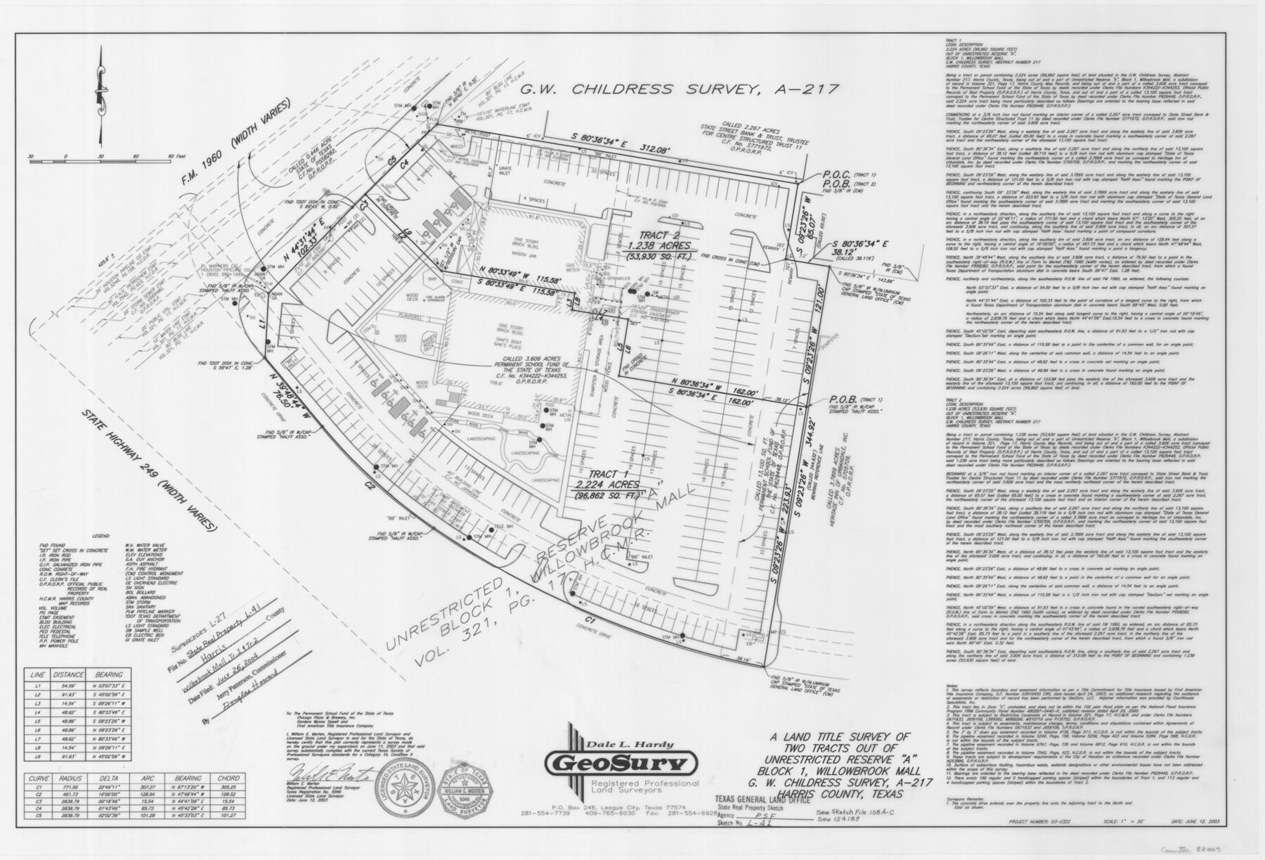
A Land Title Survey of Two Tracts Out of Unrestricted Reserve "A" Block 1, Willowbrook Mall, G. W. Childress Survey, A - 217
State Real Property Sketch L - 41
-
Map/Doc
82007
-
Collection
General Map Collection
-
Object Dates
2003/6/12 (Creation Date)
2004/7/26 (File Date)
-
People and Organizations
GeoSurv (Publisher)
GeoSurv (Printer)
William E. Merten (Surveyor/Engineer)
-
Counties
Harris
-
Subjects
State Real Property
-
Height x Width
24.5 x 36.0 inches
62.2 x 91.4 cm
-
Comments
This plat supersedes Harris County State Real Property Sketch 2, counter number 61702 and 26024 thru 26029.
See, also, School File 154189.
Surveys located about 24 miles North 39 degrees West of Houston, Texas.
Part of: General Map Collection
Flight Mission No. CRC-4R, Frame 161, Chambers County

Print $20.00
- Digital $50.00
Flight Mission No. CRC-4R, Frame 161, Chambers County
1956
Size 18.5 x 22.3 inches
Map/Doc 84920
Map of Shackelford County, North of the Clearfork of the Brazos River Young - South of il Milam - Land District

Print $20.00
- Digital $50.00
Map of Shackelford County, North of the Clearfork of the Brazos River Young - South of il Milam - Land District
1859
Size 24.8 x 19.9 inches
Map/Doc 4027
Right of Way & Track Map, San Antonio & Aransas Pass Railway Co.

Print $40.00
- Digital $50.00
Right of Way & Track Map, San Antonio & Aransas Pass Railway Co.
1919
Size 25.2 x 56.8 inches
Map/Doc 64218
Brewster County Rolled Sketch 114

Print $20.00
- Digital $50.00
Brewster County Rolled Sketch 114
1964
Size 11.4 x 18.2 inches
Map/Doc 5282
Cooke County Working Sketch 37

Print $20.00
- Digital $50.00
Cooke County Working Sketch 37
1995
Size 21.7 x 18.9 inches
Map/Doc 68274
Denton County Boundary File 1

Print $14.00
- Digital $50.00
Denton County Boundary File 1
Size 8.7 x 3.5 inches
Map/Doc 52394
Dimmit County Working Sketch 10

Print $20.00
- Digital $50.00
Dimmit County Working Sketch 10
1934
Size 24.2 x 40.3 inches
Map/Doc 68671
Galveston County Sketch File 51

Print $20.00
- Digital $50.00
Galveston County Sketch File 51
1895
Size 25.7 x 40.2 inches
Map/Doc 10457
Harris County Rolled Sketch 96B

Print $20.00
- Digital $50.00
Harris County Rolled Sketch 96B
Size 15.8 x 15.6 inches
Map/Doc 10681
Baylor County Working Sketch 8

Print $20.00
- Digital $50.00
Baylor County Working Sketch 8
1955
Size 44.1 x 20.7 inches
Map/Doc 67293
Bell County Sketch File 14

Print $4.00
- Digital $50.00
Bell County Sketch File 14
Size 12.7 x 8.3 inches
Map/Doc 14392
Wheeler County Sketch File A

Print $20.00
- Digital $50.00
Wheeler County Sketch File A
1888
Size 15.5 x 31.8 inches
Map/Doc 12677
You may also like
Cameron County Sketch File 12

Print $222.00
- Digital $50.00
Cameron County Sketch File 12
Size 10.8 x 7.4 inches
Map/Doc 17236
Map of Val Verde County

Print $40.00
- Digital $50.00
Map of Val Verde County
1898
Size 81.6 x 30.7 inches
Map/Doc 82013
Map of Matagorda Bay and County, with the adjacent country

Print $20.00
- Digital $50.00
Map of Matagorda Bay and County, with the adjacent country
1846
Size 18.3 x 26.0 inches
Map/Doc 72765
McMullen County Working Sketch 6

Print $20.00
- Digital $50.00
McMullen County Working Sketch 6
1926
Size 24.5 x 22.9 inches
Map/Doc 70707
Stonewall County Rolled Sketch 15

Print $20.00
- Digital $50.00
Stonewall County Rolled Sketch 15
1902
Size 39.2 x 28.0 inches
Map/Doc 7870
Gulf of Mexico

Print $20.00
- Digital $50.00
Gulf of Mexico
1908
Size 18.4 x 27.0 inches
Map/Doc 72657
Jeff Davis County Working Sketch 34

Print $20.00
- Digital $50.00
Jeff Davis County Working Sketch 34
1978
Size 20.4 x 38.0 inches
Map/Doc 66529
[Surveys in Henderson County, Nacogdoches/Houston District]
![69735, [Surveys in Henderson County, Nacogdoches/Houston District], General Map Collection](https://historictexasmaps.com/wmedia_w700/maps/69735.tif.jpg)
Print $2.00
- Digital $50.00
[Surveys in Henderson County, Nacogdoches/Houston District]
Size 11.0 x 7.9 inches
Map/Doc 69735
Yoakum County Rolled Sketch 7

Print $20.00
- Digital $50.00
Yoakum County Rolled Sketch 7
2012
Size 25.9 x 18.7 inches
Map/Doc 93291
![89627, [Blks. 46 & 47], Twichell Survey Records](https://historictexasmaps.com/wmedia_w700/maps/89627-1.tif.jpg)
Collingsworth County Rolled Sketch 2

Print $20.00
- Digital $50.00
Collingsworth County Rolled Sketch 2
1888
Size 30.2 x 24.8 inches
Map/Doc 5531
Montgomery County Working Sketch 10

Print $20.00
- Digital $50.00
Montgomery County Working Sketch 10
1933
Size 36.5 x 38.6 inches
Map/Doc 71117