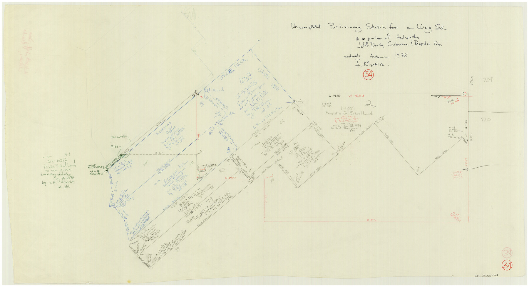
Jeff Davis County Working Sketch 34
-
Map/Doc
66529
-
Collection
General Map Collection
-
Object Dates
1978 (Creation Date)
-
People and Organizations
Joan Kilpatrick (Draftsman)
Joan Kilpatrick (Draftsman)
-
Counties
Jeff Davis Hudspeth Culberson Presidio
-
Subjects
Surveying Working Sketch
-
Height x Width
20.4 x 38.0 inches
51.8 x 96.5 cm
Part of: General Map Collection
Andrews County Rolled Sketch 39

Print $20.00
- Digital $50.00
Andrews County Rolled Sketch 39
1979
Size 43.4 x 44.3 inches
Map/Doc 8401
Lynn County Boundary File 10

Print $110.00
- Digital $50.00
Lynn County Boundary File 10
Size 14.3 x 8.7 inches
Map/Doc 56709
Jeff Davis County Sketch File 43

Print $10.00
- Digital $50.00
Jeff Davis County Sketch File 43
1970
Size 14.2 x 8.6 inches
Map/Doc 28066
Stephens County Texas

Print $20.00
- Digital $50.00
Stephens County Texas
Size 20.8 x 18.6 inches
Map/Doc 4627
McMullen County Sketch File 35

Print $10.00
- Digital $50.00
McMullen County Sketch File 35
Size 9.7 x 8.5 inches
Map/Doc 31402
Cameron County Rolled Sketch 20C

Print $20.00
- Digital $50.00
Cameron County Rolled Sketch 20C
Size 13.1 x 11.9 inches
Map/Doc 5475
[Surveys along the Leona and Frio Rivers]
![16, [Surveys along the Leona and Frio Rivers], General Map Collection](https://historictexasmaps.com/wmedia_w700/maps/16.tif.jpg)
Print $20.00
- Digital $50.00
[Surveys along the Leona and Frio Rivers]
1841
Size 12.4 x 13.1 inches
Map/Doc 16
Houston County

Print $40.00
- Digital $50.00
Houston County
1944
Size 48.3 x 49.7 inches
Map/Doc 1859
Atlantic Coast to the Rocky Mountains

Atlantic Coast to the Rocky Mountains
1956
Size 42.3 x 29.5 inches
Map/Doc 94410
Crane County Working Sketch 20

Print $40.00
- Digital $50.00
Crane County Working Sketch 20
1958
Size 61.8 x 38.1 inches
Map/Doc 68297
Pecos County Working Sketch 70

Print $20.00
- Digital $50.00
Pecos County Working Sketch 70
1957
Size 31.4 x 27.0 inches
Map/Doc 71542

You may also like
Dawson County Rolled Sketch 7

Print $20.00
- Digital $50.00
Dawson County Rolled Sketch 7
Size 18.5 x 39.3 inches
Map/Doc 5692
Corpus Christi Harbor

Print $40.00
- Digital $50.00
Corpus Christi Harbor
1972
Size 36.9 x 52.3 inches
Map/Doc 73477
Erath County Working Sketch 13

Print $20.00
- Digital $50.00
Erath County Working Sketch 13
1952
Size 31.4 x 27.1 inches
Map/Doc 69094
Andrews County Sketch File 17

Print $8.00
- Digital $50.00
Andrews County Sketch File 17
Size 11.1 x 8.6 inches
Map/Doc 12901
Gillespie County Working Sketch 14

Print $20.00
- Digital $50.00
Gillespie County Working Sketch 14
2011
Size 36.6 x 36.6 inches
Map/Doc 90096
Military Reconnaissance [showing forts along Rio Grande near Matamoros]
![72910, Military Reconnaissance [showing forts along Rio Grande near Matamoros], General Map Collection](https://historictexasmaps.com/wmedia_w700/maps/72910.tif.jpg)
Print $20.00
- Digital $50.00
Military Reconnaissance [showing forts along Rio Grande near Matamoros]
1846
Size 18.4 x 26.7 inches
Map/Doc 72910
Waller County Working Sketch 5

Print $20.00
- Digital $50.00
Waller County Working Sketch 5
1966
Size 23.1 x 27.1 inches
Map/Doc 72304
Callahan County Working Sketch 2

Print $20.00
- Digital $50.00
Callahan County Working Sketch 2
1952
Size 29.1 x 35.4 inches
Map/Doc 67884
Stephens County Working Sketch 40

Print $20.00
- Digital $50.00
Stephens County Working Sketch 40
2006
Size 26.9 x 34.0 inches
Map/Doc 87149
Hunt County Working Sketch 9

Print $20.00
- Digital $50.00
Hunt County Working Sketch 9
1959
Size 33.8 x 30.6 inches
Map/Doc 66356
Midland County Boundary File 4b

Print $18.00
- Digital $50.00
Midland County Boundary File 4b
Size 13.6 x 9.0 inches
Map/Doc 57186
Cameron County NRC Article 33.136 Location Key Sheet

Print $20.00
- Digital $50.00
Cameron County NRC Article 33.136 Location Key Sheet
1983
Size 27.0 x 22.0 inches
Map/Doc 77012