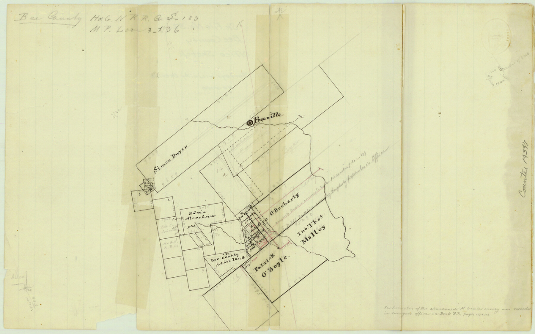
Bee County Sketch File 32
[Sketch of surveys in the vicinity and south of Beeville]
-
Map/Doc
14347
-
Collection
General Map Collection
-
Counties
Bee
-
Subjects
Surveying Sketch File
-
Height x Width
7.9 x 12.6 inches
20.1 x 32.0 cm
-
Medium
paper, manuscript
-
Features
Beeville
Part of: General Map Collection
Jones County Sketch File 15

Print $40.00
- Digital $50.00
Jones County Sketch File 15
1892
Size 13.7 x 16.3 inches
Map/Doc 28503
Reagan County Working Sketch 21

Print $20.00
- Digital $50.00
Reagan County Working Sketch 21
1955
Size 23.4 x 19.9 inches
Map/Doc 71863
Hamilton County Working Sketch 34

Print $20.00
- Digital $50.00
Hamilton County Working Sketch 34
1995
Size 37.7 x 39.8 inches
Map/Doc 63372
Young County Working Sketch 1

Print $20.00
- Digital $50.00
Young County Working Sketch 1
1960
Size 31.1 x 41.9 inches
Map/Doc 62024
Jones County Rolled Sketch 1

Print $20.00
- Digital $50.00
Jones County Rolled Sketch 1
1957
Size 17.7 x 28.1 inches
Map/Doc 6451


Webb County Sketch File 12-1

Print $16.00
- Digital $50.00
Webb County Sketch File 12-1
1886
Size 13.0 x 8.3 inches
Map/Doc 39793
Harris County

Print $40.00
- Digital $50.00
Harris County
1896
Size 44.4 x 69.3 inches
Map/Doc 66857
Flight Mission No. DAG-21K, Frame 108, Matagorda County

Print $20.00
- Digital $50.00
Flight Mission No. DAG-21K, Frame 108, Matagorda County
1952
Size 18.7 x 22.3 inches
Map/Doc 86436
Map of the West Part of Tom Green County

Print $20.00
- Digital $50.00
Map of the West Part of Tom Green County
1894
Size 46.9 x 34.7 inches
Map/Doc 63072
[Map of Nacogdoches County]
![10784, [Map of Nacogdoches County], General Map Collection](https://historictexasmaps.com/wmedia_w700/maps/10784-1.tif.jpg)
Print $40.00
- Digital $50.00
[Map of Nacogdoches County]
1840
Size 79.3 x 69.8 inches
Map/Doc 10784
You may also like
Sutton County Sketch File JAC

Print $20.00
- Digital $50.00
Sutton County Sketch File JAC
Size 24.5 x 23.4 inches
Map/Doc 12398
Dr. S. C. Arnett Farm Part Section 5, Block E2

Print $20.00
- Digital $50.00
Dr. S. C. Arnett Farm Part Section 5, Block E2
Size 12.7 x 15.8 inches
Map/Doc 92296
Eastland County Working Sketch 60a

Print $20.00
- Digital $50.00
Eastland County Working Sketch 60a
1988
Size 45.1 x 39.0 inches
Map/Doc 78209
Flight Mission No. DQN-7K, Frame 90, Calhoun County

Print $20.00
- Digital $50.00
Flight Mission No. DQN-7K, Frame 90, Calhoun County
1953
Size 18.6 x 22.2 inches
Map/Doc 84481
Matagorda County Working Sketch 28

Print $3.00
- Digital $50.00
Matagorda County Working Sketch 28
1980
Size 10.7 x 12.1 inches
Map/Doc 70886
Brewster County Sketch File S-2

Print $16.00
- Digital $50.00
Brewster County Sketch File S-2
1910
Size 17.0 x 11.0 inches
Map/Doc 15731
Live Oak County Sketch File 11b

Print $6.00
- Digital $50.00
Live Oak County Sketch File 11b
Size 8.2 x 12.6 inches
Map/Doc 30267
McMullen County Working Sketch 43

Print $20.00
- Digital $50.00
McMullen County Working Sketch 43
1980
Size 35.2 x 28.1 inches
Map/Doc 70744
Hays County Sketch File AB

Print $16.00
- Digital $50.00
Hays County Sketch File AB
1891
Size 6.3 x 8.7 inches
Map/Doc 26189
Hudspeth County Sketch File 32

Print $10.00
- Digital $50.00
Hudspeth County Sketch File 32
1952
Size 11.4 x 8.9 inches
Map/Doc 26989
[Surveys in Polk and Chambers Counties]
![355, [Surveys in Polk and Chambers Counties], General Map Collection](https://historictexasmaps.com/wmedia_w700/maps/355.tif.jpg)
Print $3.00
- Digital $50.00
[Surveys in Polk and Chambers Counties]
Size 11.7 x 14.4 inches
Map/Doc 355
Throckmorton County Working Sketch 3

Print $20.00
- Digital $50.00
Throckmorton County Working Sketch 3
1924
Size 19.8 x 23.8 inches
Map/Doc 62112