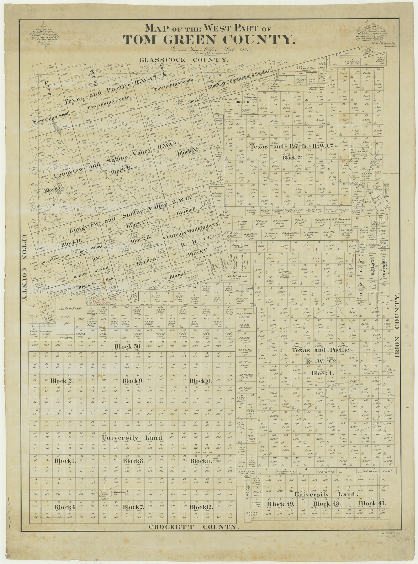
Map of the West Part of Tom Green County
-
Map/Doc
63072
-
Collection
General Map Collection
-
Object Dates
1894 (Creation Date)
-
People and Organizations
Texas General Land Office (Publisher)
W.L. McGaughey (GLO Commissioner)
-
Counties
Tom Green
-
Subjects
County
-
Height x Width
46.9 x 34.7 inches
119.1 x 88.1 cm
-
Comments
Copyrighted 1894.
Part of: General Map Collection
Castro County Boundary File 1c

Print $40.00
- Digital $50.00
Castro County Boundary File 1c
Size 24.2 x 19.2 inches
Map/Doc 51224
Henderson County Rolled Sketch 11

Print $20.00
- Digital $50.00
Henderson County Rolled Sketch 11
1915
Size 28.9 x 42.6 inches
Map/Doc 76148
Coke County Rolled Sketch 16A

Print $20.00
- Digital $50.00
Coke County Rolled Sketch 16A
Size 32.3 x 30.4 inches
Map/Doc 5518
Kleberg County Rolled Sketch 10-3

Print $20.00
- Digital $50.00
Kleberg County Rolled Sketch 10-3
1951
Size 37.5 x 32.0 inches
Map/Doc 9388
Flight Mission No. CUG-1P, Frame 168, Kleberg County

Print $20.00
- Digital $50.00
Flight Mission No. CUG-1P, Frame 168, Kleberg County
1956
Size 18.6 x 22.2 inches
Map/Doc 86175
Flight Mission No. CRE-3R, Frame 42, Jackson County

Print $20.00
- Digital $50.00
Flight Mission No. CRE-3R, Frame 42, Jackson County
1956
Size 18.6 x 22.4 inches
Map/Doc 85389

Parker County Sketch File B

Print $24.00
- Digital $50.00
Parker County Sketch File B
1858
Size 12.5 x 8.2 inches
Map/Doc 33509
Jim Hogg County Working Sketch Graphic Index

Print $20.00
- Digital $50.00
Jim Hogg County Working Sketch Graphic Index
1962
Size 40.0 x 28.7 inches
Map/Doc 76596
Flight Mission No. CRC-3R, Frame 18, Chambers County

Print $20.00
- Digital $50.00
Flight Mission No. CRC-3R, Frame 18, Chambers County
1956
Size 18.7 x 22.4 inches
Map/Doc 84792
Camp County Sketch File 1

Print $4.00
- Digital $50.00
Camp County Sketch File 1
Size 10.4 x 8.1 inches
Map/Doc 17333
Brewster County Working Sketch Graphic Index, East Part, Sheet 1 (Sketches 1 to 111)

Print $20.00
- Digital $50.00
Brewster County Working Sketch Graphic Index, East Part, Sheet 1 (Sketches 1 to 111)
1952
Size 47.4 x 29.6 inches
Map/Doc 76476
You may also like
Presidio County Rolled Sketch 131B

Print $20.00
- Digital $50.00
Presidio County Rolled Sketch 131B
1993
Size 33.4 x 46.7 inches
Map/Doc 9803
Presidio County Sketch File 34

Print $4.00
- Digital $50.00
Presidio County Sketch File 34
1891
Size 14.3 x 8.7 inches
Map/Doc 34484
Fort Bend County State Real Property Sketch 2

Print $40.00
- Digital $50.00
Fort Bend County State Real Property Sketch 2
1986
Size 34.8 x 43.4 inches
Map/Doc 61676
Tyler County Sketch File 7

Print $4.00
- Digital $50.00
Tyler County Sketch File 7
1874
Size 13.4 x 7.7 inches
Map/Doc 38637
Chapman and McFarlin Production Co. Cogdell Ranch Kent County, Texas

Print $2.00
- Digital $50.00
Chapman and McFarlin Production Co. Cogdell Ranch Kent County, Texas
1952
Size 9.0 x 8.9 inches
Map/Doc 92190
Map of Dallas County

Print $20.00
- Digital $50.00
Map of Dallas County
1861
Size 23.5 x 20.0 inches
Map/Doc 3467
Colorado County Sketch File 19

Print $4.00
- Digital $50.00
Colorado County Sketch File 19
Size 9.1 x 7.5 inches
Map/Doc 18952
[W. C. RR. Co. Blks. 1 & 2, I. & G. N. RR. Co. Blk. 1, in southeast part of County]
![90487, [W. C. RR. Co. Blks. 1 & 2, I. & G. N. RR. Co. Blk. 1, in southeast part of County], Twichell Survey Records](https://historictexasmaps.com/wmedia_w700/maps/90487-1.tif.jpg)
Print $2.00
- Digital $50.00
[W. C. RR. Co. Blks. 1 & 2, I. & G. N. RR. Co. Blk. 1, in southeast part of County]
1879
Size 6.5 x 5.8 inches
Map/Doc 90487
Correct Map of Texas

Print $20.00
- Digital $50.00
Correct Map of Texas
1873
Size 21.3 x 16.9 inches
Map/Doc 95776
Flight Mission No. CRC-5R, Frame 26, Chambers County

Print $20.00
- Digital $50.00
Flight Mission No. CRC-5R, Frame 26, Chambers County
1956
Size 18.6 x 22.5 inches
Map/Doc 84948
Lipscomb County Rolled Sketch 7

Print $20.00
- Digital $50.00
Lipscomb County Rolled Sketch 7
1968
Size 23.6 x 23.4 inches
Map/Doc 6630
San Jacinto County Sketch File 10

Print $5.00
San Jacinto County Sketch File 10
1859
Size 11.7 x 6.6 inches
Map/Doc 35714