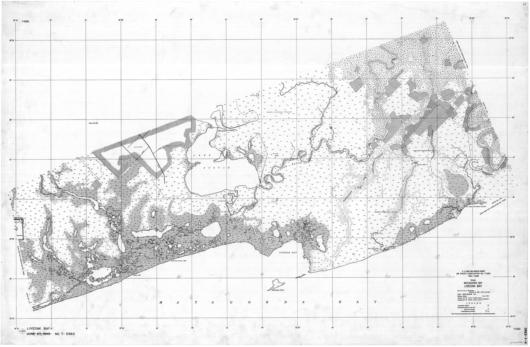
Texas, Matagorda Bay, Liveoak Bay
K-2-5360
-
Map/Doc
69992
-
Collection
General Map Collection
-
Object Dates
1933/12/19 (Creation Date)
-
Counties
Matagorda
-
Subjects
Nautical Charts
-
Height x Width
32.5 x 48.9 inches
82.6 x 124.2 cm
Part of: General Map Collection
Jackson County Sketch File 6
![27632, Jackson County Sketch File 6, General Map Collection](https://historictexasmaps.com/wmedia_w700/pdf_converted_jpg/qi_pdf_thumbnail_12195.jpg)
Print $4.00
- Digital $50.00
Jackson County Sketch File 6
1897
Size 13.1 x 8.9 inches
Map/Doc 27632
Ochiltree County Sketch File 9
![33194, Ochiltree County Sketch File 9, General Map Collection](https://historictexasmaps.com/wmedia_w700/pdf_converted_jpg/qi_pdf_thumbnail_13409.jpg)
Print $14.00
- Digital $50.00
Ochiltree County Sketch File 9
1934
Size 11.1 x 8.8 inches
Map/Doc 33194
Controlled Mosaic by Jack Amman Photogrammetric Engineers, Inc - Sheet 42
![83499, Controlled Mosaic by Jack Amman Photogrammetric Engineers, Inc - Sheet 42, General Map Collection](https://historictexasmaps.com/wmedia_w700/maps/83499.tif.jpg)
Print $20.00
- Digital $50.00
Controlled Mosaic by Jack Amman Photogrammetric Engineers, Inc - Sheet 42
1954
Size 20.0 x 24.0 inches
Map/Doc 83499
Flight Mission No. BRA-7M, Frame 7, Jefferson County
![85458, Flight Mission No. BRA-7M, Frame 7, Jefferson County, General Map Collection](https://historictexasmaps.com/wmedia_w700/pdf_converted_jpg/qi_pdf_thumbnail_32658.jpg)
Print $20.00
- Digital $50.00
Flight Mission No. BRA-7M, Frame 7, Jefferson County
1953
Size 18.7 x 22.5 inches
Map/Doc 85458
Bexar County Working Sketch 17
![67333, Bexar County Working Sketch 17, General Map Collection](https://historictexasmaps.com/wmedia_w700/maps/67333.tif.jpg)
Print $20.00
- Digital $50.00
Bexar County Working Sketch 17
1978
Size 22.8 x 34.2 inches
Map/Doc 67333
Duval County Sketch File 60
![21428, Duval County Sketch File 60, General Map Collection](https://historictexasmaps.com/wmedia_w700/pdf_converted_jpg/qi_pdf_thumbnail_10876.jpg)
Print $6.00
- Digital $50.00
Duval County Sketch File 60
1940
Size 11.3 x 9.0 inches
Map/Doc 21428
University Lands Blocks 29-33, Crockett County, Texas
![2407, University Lands Blocks 29-33, Crockett County, Texas, General Map Collection](https://historictexasmaps.com/wmedia_w700/maps/2407.tif.jpg)
Print $20.00
- Digital $50.00
University Lands Blocks 29-33, Crockett County, Texas
1936
Size 29.2 x 42.4 inches
Map/Doc 2407
Hall County Sketch File B1
![11612, Hall County Sketch File B1, General Map Collection](https://historictexasmaps.com/wmedia_w700/pdf_converted_jpg/qi_pdf_thumbnail_8050.jpg)
Print $20.00
- Digital $50.00
Hall County Sketch File B1
1904
Size 23.4 x 25.4 inches
Map/Doc 11612
Briscoe County Sketch File 16
![16535, Briscoe County Sketch File 16, General Map Collection](https://historictexasmaps.com/wmedia_w700/pdf_converted_jpg/qi_pdf_thumbnail_9686.jpg)
Print $4.00
- Digital $50.00
Briscoe County Sketch File 16
1913
Size 13.4 x 9.1 inches
Map/Doc 16535
Map of the Southern Pacific Rail Road through Harrison County, Texas
![64140, Map of the Southern Pacific Rail Road through Harrison County, Texas, General Map Collection](https://historictexasmaps.com/wmedia_w700/maps/64140-GC.tif.jpg)
Print $40.00
- Digital $50.00
Map of the Southern Pacific Rail Road through Harrison County, Texas
1860
Size 26.8 x 76.6 inches
Map/Doc 64140
Texas Gulf Coast Map from the Sabine River to the Rio Grande as subdivided for mineral development
![2912, Texas Gulf Coast Map from the Sabine River to the Rio Grande as subdivided for mineral development, General Map Collection](https://historictexasmaps.com/wmedia_w700/maps/2912.tif.jpg)
Print $20.00
- Digital $50.00
Texas Gulf Coast Map from the Sabine River to the Rio Grande as subdivided for mineral development
1948
Size 31.0 x 39.7 inches
Map/Doc 2912
[Gulf, Colorado & Santa Fe]
![64590, [Gulf, Colorado & Santa Fe], General Map Collection](https://historictexasmaps.com/wmedia_w700/maps/64590.tif.jpg)
Print $40.00
- Digital $50.00
[Gulf, Colorado & Santa Fe]
1918
Size 31.4 x 117.0 inches
Map/Doc 64590
You may also like
Reeves County Rolled Sketch 33
![7501, Reeves County Rolled Sketch 33, General Map Collection](https://historictexasmaps.com/wmedia_w700/maps/7501.tif.jpg)
Print $20.00
- Digital $50.00
Reeves County Rolled Sketch 33
Size 24.7 x 36.9 inches
Map/Doc 7501
Scurry County Rolled Sketch 2
![9911, Scurry County Rolled Sketch 2, General Map Collection](https://historictexasmaps.com/wmedia_w700/maps/9911.tif.jpg)
Print $20.00
- Digital $50.00
Scurry County Rolled Sketch 2
Size 44.0 x 44.9 inches
Map/Doc 9911
Foard County Sketch File 21
![22839, Foard County Sketch File 21, General Map Collection](https://historictexasmaps.com/wmedia_w700/pdf_converted_jpg/qi_pdf_thumbnail_11172.jpg)
Print $14.00
- Digital $50.00
Foard County Sketch File 21
Size 13.1 x 8.6 inches
Map/Doc 22839
The Republic County of San Augustine. Boundaries Defined, December 14, 1837
![96271, The Republic County of San Augustine. Boundaries Defined, December 14, 1837, Nancy and Jim Tiller Digital Collection](https://historictexasmaps.com/wmedia_w700/maps/96271.tif.jpg)
Print $20.00
- Digital $50.00
The Republic County of San Augustine. Boundaries Defined, December 14, 1837
2020
Size 9.4 x 10.8 inches
Map/Doc 96271
Webb County Rolled Sketch 20
![8182, Webb County Rolled Sketch 20, General Map Collection](https://historictexasmaps.com/wmedia_w700/maps/8182.tif.jpg)
Print $20.00
- Digital $50.00
Webb County Rolled Sketch 20
1928
Size 38.1 x 29.0 inches
Map/Doc 8182
Culberson County Working Sketch 43
![68497, Culberson County Working Sketch 43, General Map Collection](https://historictexasmaps.com/wmedia_w700/maps/68497.tif.jpg)
Print $40.00
- Digital $50.00
Culberson County Working Sketch 43
Size 52.4 x 38.0 inches
Map/Doc 68497
Right of Way and Track Map of The Missouri, Kansas & Texas Railway of Texas
![64538, Right of Way and Track Map of The Missouri, Kansas & Texas Railway of Texas, General Map Collection](https://historictexasmaps.com/wmedia_w700/maps/64538.tif.jpg)
Print $40.00
- Digital $50.00
Right of Way and Track Map of The Missouri, Kansas & Texas Railway of Texas
1918
Size 24.4 x 50.7 inches
Map/Doc 64538
Flight Mission No. BQY-4M, Frame 56, Harris County
![85265, Flight Mission No. BQY-4M, Frame 56, Harris County, General Map Collection](https://historictexasmaps.com/wmedia_w700/pdf_converted_jpg/qi_pdf_thumbnail_32469.jpg)
Print $20.00
- Digital $50.00
Flight Mission No. BQY-4M, Frame 56, Harris County
1953
Size 18.6 x 22.4 inches
Map/Doc 85265
Carte Reduite du Golphe du Mexique et des isles de l'Amerique dressée au depost des cartes et plans de la Marine pour le service des vaisseaux du Roy
![94097, Carte Reduite du Golphe du Mexique et des isles de l'Amerique dressée au depost des cartes et plans de la Marine pour le service des vaisseaux du Roy, General Map Collection](https://historictexasmaps.com/wmedia_w700/maps/94097.tif.jpg)
Print $20.00
- Digital $50.00
Carte Reduite du Golphe du Mexique et des isles de l'Amerique dressée au depost des cartes et plans de la Marine pour le service des vaisseaux du Roy
1774
Size 25.5 x 32.9 inches
Map/Doc 94097
Kendall County Rolled Sketch 8
![6461, Kendall County Rolled Sketch 8, General Map Collection](https://historictexasmaps.com/wmedia_w700/maps/6461.tif.jpg)
Print $20.00
- Digital $50.00
Kendall County Rolled Sketch 8
1994
Size 17.0 x 18.3 inches
Map/Doc 6461
Bailey County Rolled Sketch 7
![8931, Bailey County Rolled Sketch 7, General Map Collection](https://historictexasmaps.com/wmedia_w700/maps/8931.tif.jpg)
Print $40.00
- Digital $50.00
Bailey County Rolled Sketch 7
1941
Size 67.1 x 43.1 inches
Map/Doc 8931
Map of Angelina County
![3233, Map of Angelina County, General Map Collection](https://historictexasmaps.com/wmedia_w700/maps/3233-GC.tif.jpg)
Print $20.00
- Digital $50.00
Map of Angelina County
1862
Size 19.1 x 27.0 inches
Map/Doc 3233