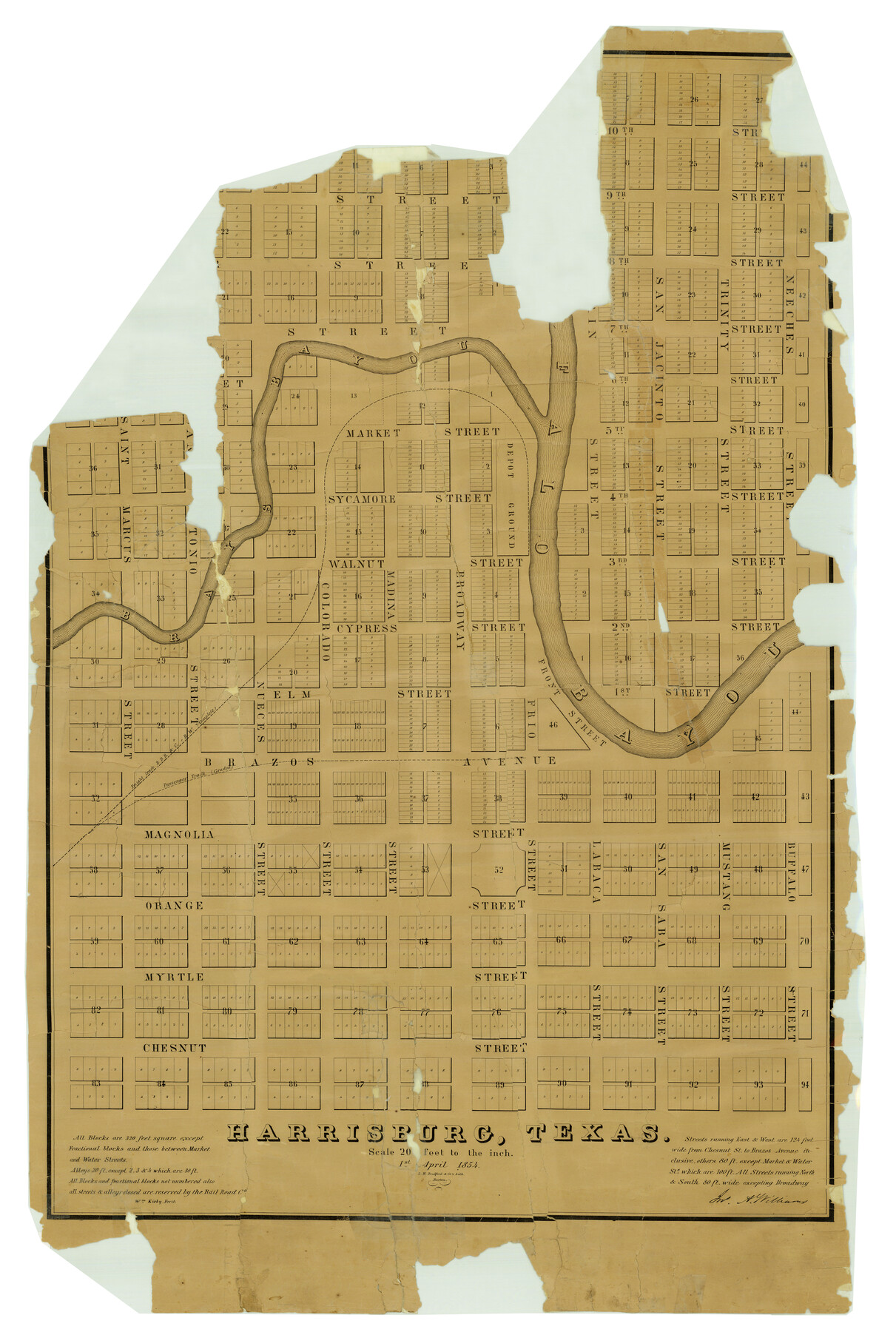
Harrisburg, Texas
A-6-31
-
Map/Doc
3044
-
Collection
General Map Collection
-
Object Dates
4/1/1854 (Creation Date)
-
People and Organizations
L. H. Bradford and Company (Printer)
John A. Williams (Surveyor/Engineer)
William Kirby (Draftsman)
-
Counties
Harris
-
Subjects
City
-
Height x Width
39.4 x 25.7 inches
100.1 x 65.3 cm
-
Medium
paper, etching/engraving/lithograph
-
Scale
1" = 200 ft.
-
Comments
Conservation funded in 2002 with donations from John Daugherty Realtors and Cooke and Skidmore Consulting Corporation.
-
Features
Buffalo Bayou
Harrisburg
Brays Bayou
BBB&C
-
URLs
https://medium.com/save-texas-history/mapping-texas-from-frontier-to-the-lone-star-state-harrisburg-texas-7c66053d8c2
Part of: General Map Collection
Hardeman County Sketch File 29

Print $20.00
- Digital $50.00
Hardeman County Sketch File 29
1890
Size 12.9 x 8.2 inches
Map/Doc 25056
Kerr County Rolled Sketch 20

Print $20.00
- Digital $50.00
Kerr County Rolled Sketch 20
1955
Size 30.2 x 35.2 inches
Map/Doc 6502
Flight Mission No. CRE-1R, Frame 194, Jackson County

Print $20.00
- Digital $50.00
Flight Mission No. CRE-1R, Frame 194, Jackson County
1956
Size 18.5 x 22.3 inches
Map/Doc 85348
Flight Mission No. CGI-3N, Frame 173, Cameron County

Print $20.00
- Digital $50.00
Flight Mission No. CGI-3N, Frame 173, Cameron County
1954
Size 18.5 x 22.3 inches
Map/Doc 84637
Val Verde County Sketch File 51

Print $10.00
- Digital $50.00
Val Verde County Sketch File 51
1959
Size 9.8 x 8.7 inches
Map/Doc 39320
Zavala County Working Sketch 30

Print $20.00
- Digital $50.00
Zavala County Working Sketch 30
1989
Size 36.8 x 28.1 inches
Map/Doc 62105
San Antonio - Downtown - Riverwalk

San Antonio - Downtown - Riverwalk
Size 11.8 x 17.8 inches
Map/Doc 94290
Tom Green County Boundary File 4

Print $70.00
- Digital $50.00
Tom Green County Boundary File 4
Size 8.8 x 6.8 inches
Map/Doc 59347
Jefferson County NRC Article 33.136 Sketch 11

Print $46.00
- Digital $50.00
Jefferson County NRC Article 33.136 Sketch 11
2012
Size 24.0 x 36.0 inches
Map/Doc 95011
Flight Mission No. CRK-7P, Frame 25, Refugio County

Print $20.00
- Digital $50.00
Flight Mission No. CRK-7P, Frame 25, Refugio County
1956
Size 18.6 x 22.3 inches
Map/Doc 86945
Lamar County Working Sketch 8

Print $20.00
- Digital $50.00
Lamar County Working Sketch 8
1969
Size 39.3 x 31.6 inches
Map/Doc 70269
San Patricio County Sketch File 10

Print $8.00
San Patricio County Sketch File 10
1847
Size 13.3 x 8.4 inches
Map/Doc 36040
You may also like
Dawson County Sketch File 11

Print $20.00
- Digital $50.00
Dawson County Sketch File 11
1927
Size 18.6 x 20.9 inches
Map/Doc 11293
Sutton County Working Sketch Graphic Index, Sheet 1 (Sketches 1 to 24)

Print $40.00
- Digital $50.00
Sutton County Working Sketch Graphic Index, Sheet 1 (Sketches 1 to 24)
1941
Size 41.9 x 55.3 inches
Map/Doc 76705
The Chief Justice County of Bexar. May 1, 1837

Print $20.00
The Chief Justice County of Bexar. May 1, 1837
2020
Size 25.4 x 21.6 inches
Map/Doc 96038
Flight Mission No. CGI-3N, Frame 109, Cameron County

Print $20.00
- Digital $50.00
Flight Mission No. CGI-3N, Frame 109, Cameron County
1954
Size 18.5 x 22.1 inches
Map/Doc 84589
Jefferson County Sketch File 55

Print $30.00
- Digital $50.00
Jefferson County Sketch File 55
1982
Size 11.1 x 8.5 inches
Map/Doc 28386
Controlled Mosaic by Jack Amman Photogrammetric Engineers, Inc - Sheet 12

Print $20.00
- Digital $50.00
Controlled Mosaic by Jack Amman Photogrammetric Engineers, Inc - Sheet 12
1954
Size 20.0 x 24.0 inches
Map/Doc 83456
The Peters Colony. January 29, 1844

Print $20.00
The Peters Colony. January 29, 1844
2020
Size 17.2 x 21.7 inches
Map/Doc 96366
Gregg County Sketch File 1F

Print $4.00
- Digital $50.00
Gregg County Sketch File 1F
1850
Size 12.2 x 7.8 inches
Map/Doc 24547
Archer County Boundary File 7

Print $10.00
- Digital $50.00
Archer County Boundary File 7
Size 8.2 x 5.2 inches
Map/Doc 50116
Loving County Working Sketch 4

Print $20.00
- Digital $50.00
Loving County Working Sketch 4
1941
Size 20.1 x 40.2 inches
Map/Doc 70636
Crockett County Sketch File 75

Print $20.00
- Digital $50.00
Crockett County Sketch File 75
Size 26.3 x 28.8 inches
Map/Doc 11234
Crockett County Rolled Sketch 77

Print $20.00
- Digital $50.00
Crockett County Rolled Sketch 77
1952
Size 26.9 x 28.6 inches
Map/Doc 5618