Jefferson County NRC Article 33.136 Sketch 11
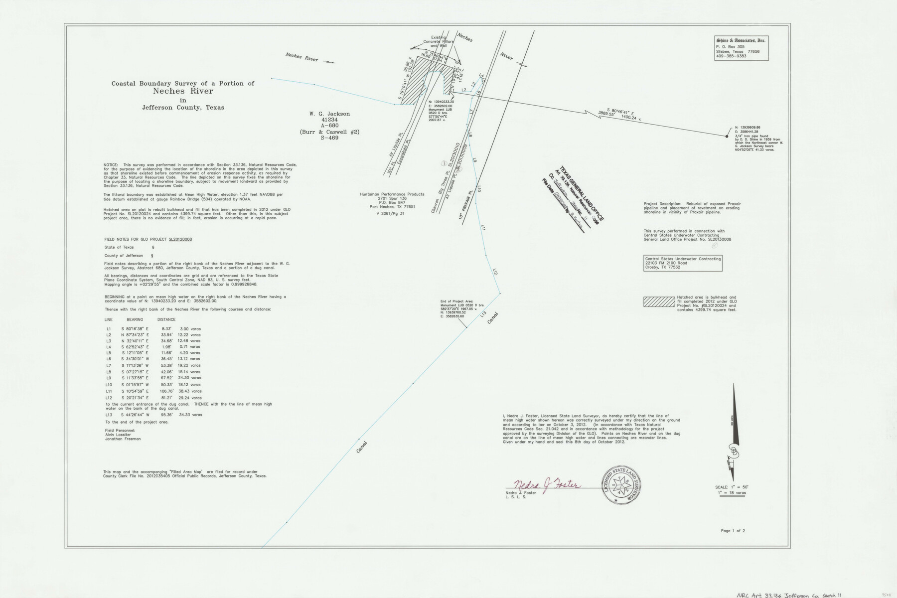
Coastal Boundary Survey of a portion of Neches River in Jefferson County, Texas
-
Map/Doc
95011
-
Collection
General Map Collection
-
Object Dates
2012/10/8 (Creation Date)
2018/6/20 (File Date)
-
People and Organizations
Nedra J. Foster (Surveyor/Engineer)
-
Counties
Jefferson
-
Subjects
Surveying CBS
-
Height x Width
24.0 x 36.0 inches
61.0 x 91.4 cm
-
Medium
multi-page, multi-format
-
Scale
1" = 50' = 18 varas
-
Comments
Project: Central State Underwater Contracting - Praxair Pipeline Reburial, Central State Underwater Contracting - Air Liquide Pipeline Reburial, Central State Underwater Contracting - Chevron Pipeline Reburial Project No.: SL20130008 (GLO)(Praxair); SL20130009 (GLO)(Air Liquide); SL20130010 (GLO)(Chevron)
Part of: General Map Collection
Flight Mission No. BRA-17M, Frame 16, Jefferson County

Print $20.00
- Digital $50.00
Flight Mission No. BRA-17M, Frame 16, Jefferson County
1953
Size 18.5 x 22.3 inches
Map/Doc 85797
Val Verde County Working Sketch 26

Print $20.00
- Digital $50.00
Val Verde County Working Sketch 26
1936
Size 22.9 x 31.5 inches
Map/Doc 72161
Loving County Working Sketch 25

Print $40.00
- Digital $50.00
Loving County Working Sketch 25
1952
Size 49.6 x 22.1 inches
Map/Doc 70659
Grayson County Working Sketch 15

Print $20.00
- Digital $50.00
Grayson County Working Sketch 15
1953
Size 24.8 x 20.6 inches
Map/Doc 63254
Flight Mission No. BRA-7M, Frame 145, Jefferson County

Print $20.00
- Digital $50.00
Flight Mission No. BRA-7M, Frame 145, Jefferson County
1953
Size 16.0 x 16.0 inches
Map/Doc 85539
Flight Mission No. CRC-3R, Frame 15, Chambers County

Print $20.00
- Digital $50.00
Flight Mission No. CRC-3R, Frame 15, Chambers County
1956
Size 18.5 x 22.2 inches
Map/Doc 84789
Flight Mission No. BQR-5K, Frame 63, Brazoria County

Print $20.00
- Digital $50.00
Flight Mission No. BQR-5K, Frame 63, Brazoria County
1952
Size 19.0 x 22.6 inches
Map/Doc 84008
Cooke County Sketch File 14

Print $4.00
- Digital $50.00
Cooke County Sketch File 14
Size 10.3 x 8.2 inches
Map/Doc 19248
Map of Taylor, Bastrop & Houston Railroad in Williamson, Travis, & Bastrop Counties, Texas

Print $20.00
- Digital $50.00
Map of Taylor, Bastrop & Houston Railroad in Williamson, Travis, & Bastrop Counties, Texas
1887
Size 26.3 x 17.8 inches
Map/Doc 65468
Map of Runnels County

Print $20.00
- Digital $50.00
Map of Runnels County
1898
Size 43.2 x 36.9 inches
Map/Doc 16803
Flight Mission No. BRA-7M, Frame 190, Jefferson County

Print $20.00
- Digital $50.00
Flight Mission No. BRA-7M, Frame 190, Jefferson County
1953
Size 18.7 x 22.3 inches
Map/Doc 85558

You may also like
The Republic County of Fayette. Created, December 14, 1837

Print $20.00
The Republic County of Fayette. Created, December 14, 1837
2020
Size 14.7 x 21.7 inches
Map/Doc 96131
Flight Mission No. DCL-6C, Frame 174, Kenedy County

Print $20.00
- Digital $50.00
Flight Mission No. DCL-6C, Frame 174, Kenedy County
1943
Size 18.7 x 22.3 inches
Map/Doc 85986
Flight Mission No. DQN-5K, Frame 149, Calhoun County

Print $20.00
- Digital $50.00
Flight Mission No. DQN-5K, Frame 149, Calhoun County
1953
Size 18.5 x 22.2 inches
Map/Doc 84424
Hardeman County Working Sketch 3

Print $20.00
- Digital $50.00
Hardeman County Working Sketch 3
1919
Size 32.7 x 35.1 inches
Map/Doc 63384
Jefferson County Rolled Sketch 34

Print $20.00
- Digital $50.00
Jefferson County Rolled Sketch 34
1957
Size 43.9 x 34.6 inches
Map/Doc 9296
Martin County Rolled Sketch 7

Print $20.00
- Digital $50.00
Martin County Rolled Sketch 7
1929
Size 23.0 x 31.2 inches
Map/Doc 6667
Kimble County Working Sketch 54

Print $20.00
- Digital $50.00
Kimble County Working Sketch 54
1954
Size 32.3 x 23.1 inches
Map/Doc 70122
Fort Bend County

Print $20.00
- Digital $50.00
Fort Bend County
1873
Size 18.0 x 21.4 inches
Map/Doc 3555
The Republic County of San Patricio. December 29, 1845

Print $20.00
The Republic County of San Patricio. December 29, 1845
2020
Size 22.2 x 21.7 inches
Map/Doc 96278
Flight Mission No. BRA-7M, Frame 129, Jefferson County

Print $20.00
- Digital $50.00
Flight Mission No. BRA-7M, Frame 129, Jefferson County
1953
Size 16.3 x 16.0 inches
Map/Doc 85523
San Patricio County Rolled Sketch 46

Print $20.00
- Digital $50.00
San Patricio County Rolled Sketch 46
1983
Size 19.6 x 25.5 inches
Map/Doc 7730
Waller County Sketch File 2

Print $52.00
- Digital $50.00
Waller County Sketch File 2
Size 13.3 x 9.0 inches
Map/Doc 39570