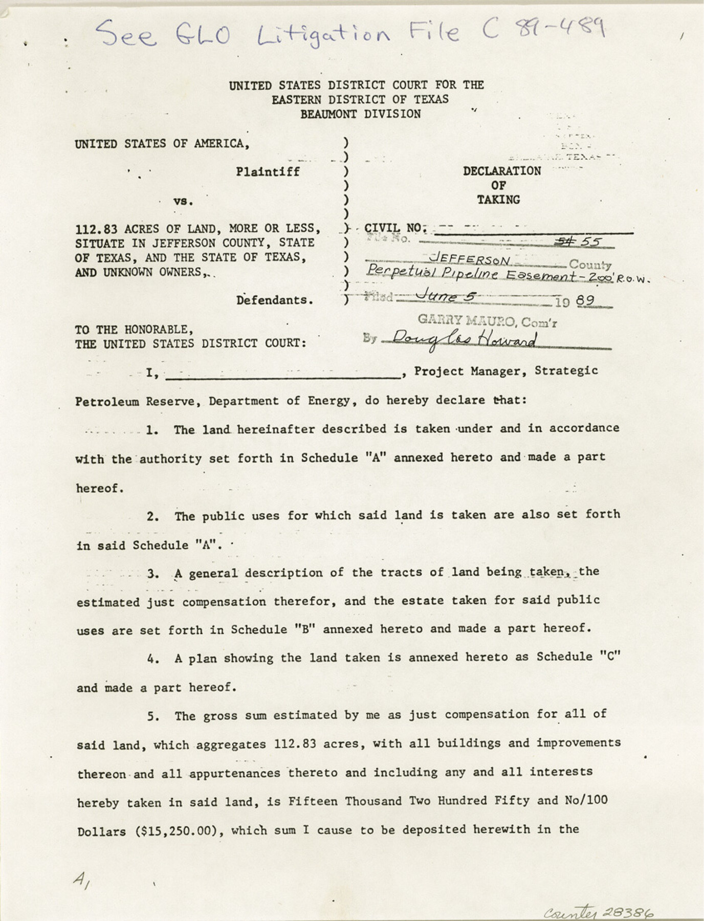
Jefferson County Sketch File 55
[Perpetual easement for pipeline - 200 ft. ROW and Court Judgment]
-
Map/Doc
28386
-
Collection
General Map Collection
-
Object Dates
6/5/1989 (File Date)
11/29/1982 (Creation Date)
-
Counties
Jefferson
-
Subjects
Surveying Sketch File
-
Height x Width
11.1 x 8.5 inches
28.2 x 21.6 cm
-
Medium
paper, print
-
Features
Gulf of Mexico
High Island
Part of: General Map Collection
[Sketch for Mineral Application 13440]
![65674, [Sketch for Mineral Application 13440], General Map Collection](https://historictexasmaps.com/wmedia_w700/maps/65674-1.tif.jpg)
Print $40.00
- Digital $50.00
[Sketch for Mineral Application 13440]
Size 65.8 x 42.9 inches
Map/Doc 65674
Hemphill County Working Sketch 23

Print $40.00
- Digital $50.00
Hemphill County Working Sketch 23
1973
Size 36.4 x 59.6 inches
Map/Doc 66118
Map of the United States with its territories: also Mexico and the West Indies

Print $20.00
- Digital $50.00
Map of the United States with its territories: also Mexico and the West Indies
1851
Size 40.1 x 36.7 inches
Map/Doc 93925
Map of Fort Bend Co.

Print $20.00
- Digital $50.00
Map of Fort Bend Co.
1898
Size 45.3 x 41.6 inches
Map/Doc 4949
Wood County Working Sketch 19

Print $20.00
- Digital $50.00
Wood County Working Sketch 19
1982
Size 25.8 x 24.8 inches
Map/Doc 62019
Sutton County Working Sketch 66

Print $20.00
- Digital $50.00
Sutton County Working Sketch 66
1972
Size 29.0 x 39.3 inches
Map/Doc 62409
Map of the International and Great Northern Railroad between Austin and San Antonio, Texas

Print $40.00
- Digital $50.00
Map of the International and Great Northern Railroad between Austin and San Antonio, Texas
1881
Size 42.5 x 121.5 inches
Map/Doc 64776
Erath County Working Sketch 6

Print $20.00
- Digital $50.00
Erath County Working Sketch 6
1920
Size 40.9 x 33.1 inches
Map/Doc 69087
[Texas & Pacific Railway through Callahan County]
![64233, [Texas & Pacific Railway through Callahan County], General Map Collection](https://historictexasmaps.com/wmedia_w700/maps/64233.tif.jpg)
Print $20.00
- Digital $50.00
[Texas & Pacific Railway through Callahan County]
1918
Size 20.5 x 9.4 inches
Map/Doc 64233
Henderson County

Print $40.00
- Digital $50.00
Henderson County
1922
Size 33.0 x 62.7 inches
Map/Doc 66861
Henderson County Working Sketch 32

Print $40.00
- Digital $50.00
Henderson County Working Sketch 32
1963
Size 56.5 x 50.0 inches
Map/Doc 66165
Harris County Working Sketch 51

Print $20.00
- Digital $50.00
Harris County Working Sketch 51
1947
Size 39.6 x 36.6 inches
Map/Doc 65943
You may also like
Val Verde County Working Sketch 62

Print $40.00
- Digital $50.00
Val Verde County Working Sketch 62
1959
Size 38.3 x 56.6 inches
Map/Doc 72197
[Unorganized County School Land Leagues 284 - 317]
![90856, [Unorganized County School Land Leagues 284 - 317], Twichell Survey Records](https://historictexasmaps.com/wmedia_w700/maps/90856-2.tif.jpg)
Print $20.00
- Digital $50.00
[Unorganized County School Land Leagues 284 - 317]
1902
Size 30.2 x 20.6 inches
Map/Doc 90856
![88910, Bosque Co[unty], Library of Congress](https://historictexasmaps.com/wmedia_w700/maps/88910.tif.jpg)
Bailey County Working Sketch 6

Print $20.00
- Digital $50.00
Bailey County Working Sketch 6
1966
Size 37.0 x 34.5 inches
Map/Doc 67593
Fisher County Working Sketch 13

Print $20.00
- Digital $50.00
Fisher County Working Sketch 13
1956
Size 29.8 x 32.7 inches
Map/Doc 69147
Dallas County Boundary File 7 and 7a and 7b

Print $26.00
- Digital $50.00
Dallas County Boundary File 7 and 7a and 7b
Size 11.2 x 8.6 inches
Map/Doc 52278
Marion County Rolled Sketch 6

Print $20.00
- Digital $50.00
Marion County Rolled Sketch 6
1979
Size 12.2 x 18.3 inches
Map/Doc 6659
Flight Mission No. CGI-3N, Frame 131, Cameron County

Print $20.00
- Digital $50.00
Flight Mission No. CGI-3N, Frame 131, Cameron County
1954
Size 18.7 x 22.3 inches
Map/Doc 84604
Plan of the City of Austin

Print $20.00
Plan of the City of Austin
1853
Size 13.9 x 11.5 inches
Map/Doc 76207

Taylor County Rolled Sketch 19

Print $20.00
- Digital $50.00
Taylor County Rolled Sketch 19
1886
Size 23.5 x 30.8 inches
Map/Doc 7913
Kerr County Boundary File 55

Print $64.00
- Digital $50.00
Kerr County Boundary File 55
Size 8.7 x 3.5 inches
Map/Doc 64826