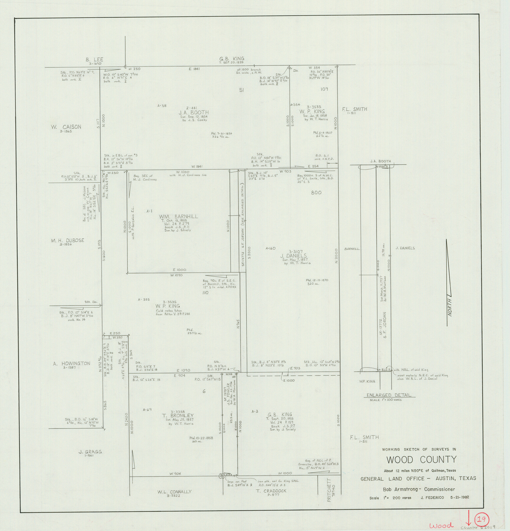
Wood County Working Sketch 19
-
Map/Doc
62019
-
Collection
General Map Collection
-
Object Dates
5/21/1982 (Creation Date)
-
People and Organizations
Jeff Federico (Draftsman)
-
Counties
Wood
-
Subjects
Surveying Working Sketch
-
Height x Width
25.8 x 24.8 inches
65.5 x 63.0 cm
-
Scale
1" = 200 varas
Part of: General Map Collection
Flight Mission No. CGI-1N, Frame 142, Cameron County

Print $20.00
- Digital $50.00
Flight Mission No. CGI-1N, Frame 142, Cameron County
1955
Size 18.5 x 22.2 inches
Map/Doc 84498
Burnet County Working Sketch Graphic Index

Print $20.00
- Digital $50.00
Burnet County Working Sketch Graphic Index
1924
Size 46.5 x 41.2 inches
Map/Doc 76482
Flight Mission No. DAG-18K, Frame 68, Matagorda County

Print $20.00
- Digital $50.00
Flight Mission No. DAG-18K, Frame 68, Matagorda County
1952
Size 16.4 x 16.3 inches
Map/Doc 86361
Nueces County Sketch File 16

Print $6.00
- Digital $50.00
Nueces County Sketch File 16
1875
Size 15.5 x 10.7 inches
Map/Doc 32547
Lampasas County Sketch File 4

Print $4.00
- Digital $50.00
Lampasas County Sketch File 4
1861
Size 12.3 x 8.2 inches
Map/Doc 29394
Wichita County Working Sketch 5

Print $20.00
- Digital $50.00
Wichita County Working Sketch 5
1913
Size 18.2 x 27.0 inches
Map/Doc 72514
Rains County Working Sketch 5

Print $20.00
- Digital $50.00
Rains County Working Sketch 5
1950
Size 35.2 x 42.0 inches
Map/Doc 71831
Zavala County Working Sketch 4

Print $20.00
- Digital $50.00
Zavala County Working Sketch 4
1936
Size 21.1 x 23.4 inches
Map/Doc 62079
Newton County Sketch File 40

Print $6.00
- Digital $50.00
Newton County Sketch File 40
Size 16.2 x 10.6 inches
Map/Doc 32419
Stephens County Boundary File 3

Print $25.00
- Digital $50.00
Stephens County Boundary File 3
Size 14.2 x 8.8 inches
Map/Doc 58882
Port Series No. 6 - The Ports of Galveston, Houston, and Texas City, Texas

Port Series No. 6 - The Ports of Galveston, Houston, and Texas City, Texas
1924
Map/Doc 97159
Flight Mission No. DQO-6K, Frame 22, Galveston County

Print $20.00
- Digital $50.00
Flight Mission No. DQO-6K, Frame 22, Galveston County
1952
Size 18.8 x 22.4 inches
Map/Doc 85095
You may also like
Subdivision of Sutton County School League 175. Bailey County, Texas

Print $2.00
- Digital $50.00
Subdivision of Sutton County School League 175. Bailey County, Texas
1929
Size 9.1 x 11.5 inches
Map/Doc 90278
Erath County Working Sketch 34

Print $20.00
- Digital $50.00
Erath County Working Sketch 34
1972
Size 38.7 x 25.3 inches
Map/Doc 69115
Motley County Sketch File 2-D

Print $40.00
- Digital $50.00
Motley County Sketch File 2-D
1903
Size 16.3 x 24.7 inches
Map/Doc 42134
Crockett County Sketch File 88

Print $3.00
- Digital $50.00
Crockett County Sketch File 88
1958
Size 19.3 x 15.8 inches
Map/Doc 11237

Tarrant County Working Sketch 14

Print $20.00
- Digital $50.00
Tarrant County Working Sketch 14
1989
Size 26.5 x 31.0 inches
Map/Doc 62431


Harris County Rolled Sketch 30

Print $20.00
- Digital $50.00
Harris County Rolled Sketch 30
1889
Size 30.4 x 35.1 inches
Map/Doc 6096
Gray County Sketch File 1

Print $4.00
- Digital $50.00
Gray County Sketch File 1
1882
Size 10.4 x 7.2 inches
Map/Doc 24396
Texas Gulf Coast, from the Sabine River to the Rio Grande as Subdivided for Mineral Development; Jefferson, Chambers and Galveston Counties

Print $20.00
- Digital $50.00
Texas Gulf Coast, from the Sabine River to the Rio Grande as Subdivided for Mineral Development; Jefferson, Chambers and Galveston Counties
1976
Size 29.0 x 42.5 inches
Map/Doc 1937
Presidio County Rolled Sketch 144

Print $20.00
- Digital $50.00
Presidio County Rolled Sketch 144
2010
Size 36.0 x 24.0 inches
Map/Doc 89603