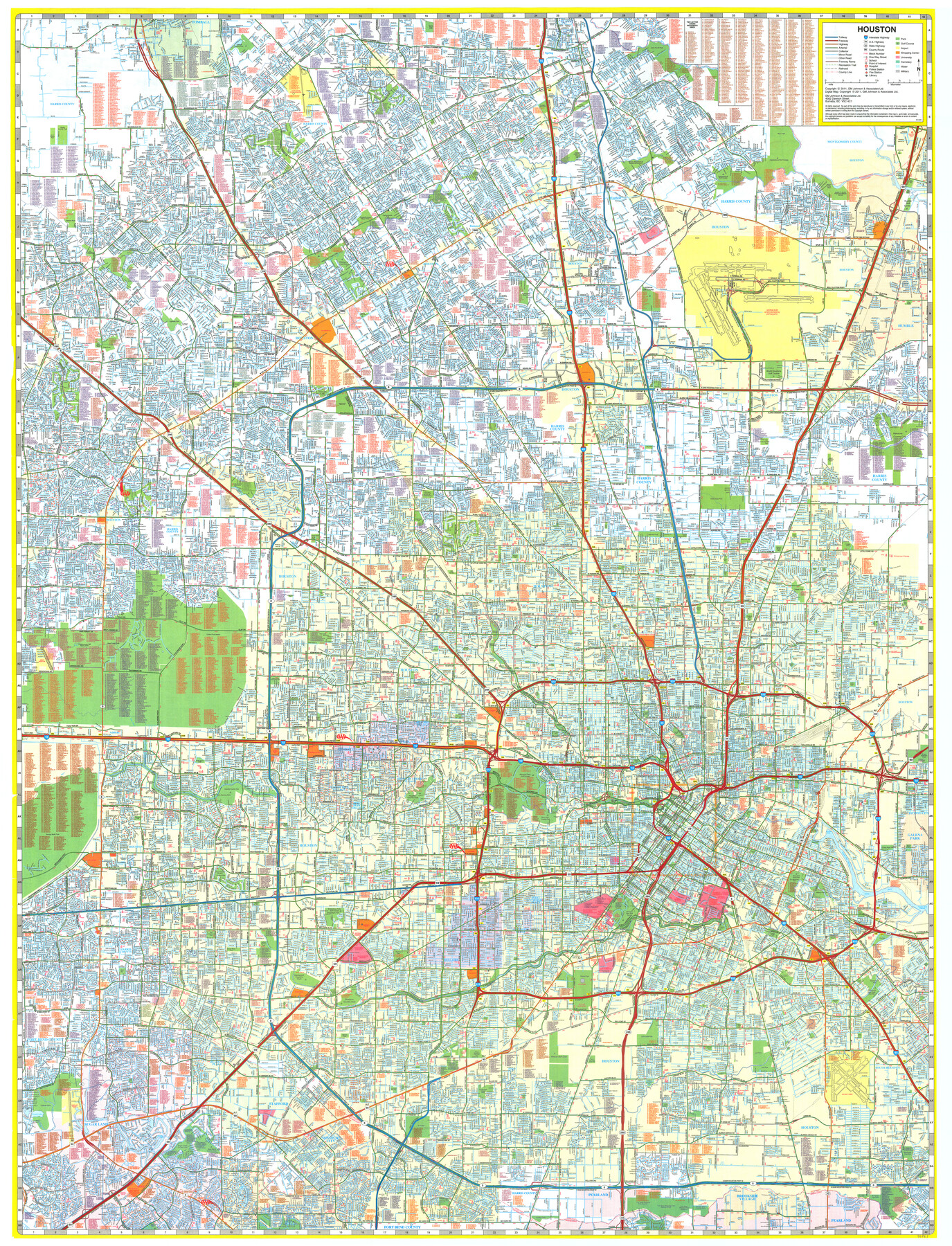
Houston
-
Map/Doc
96863
-
Collection
General Map Collection
-
Object Dates
2011 (Creation Date)
-
People and Organizations
GM Johnson & Associates, Ltd. (Publisher)
Mark Lambert (Donor)
-
Counties
Harris Montgomery
-
Subjects
City
-
Height x Width
48.2 x 36.8 inches
122.4 x 93.5 cm
-
Medium
paper, print
-
Comments
For research only. Donated by Mark Lambert in May, 2022. See 96864 for verso.
Related maps

Part of: General Map Collection
Flight Mission No. CRE-2R, Frame 161, Jackson County

Print $20.00
- Digital $50.00
Flight Mission No. CRE-2R, Frame 161, Jackson County
1956
Size 18.5 x 22.1 inches
Map/Doc 85372
Aransas County Rolled Sketch 23
Print $40.00
- Digital $50.00
Aransas County Rolled Sketch 23
1970
Size 90.9 x 38.8 inches
Map/Doc 8417
Map of Corpus Christi Bay in Nueces County Showing Subdivision Thereof for Mineral Development

Print $20.00
- Digital $50.00
Map of Corpus Christi Bay in Nueces County Showing Subdivision Thereof for Mineral Development
1940
Size 23.3 x 34.7 inches
Map/Doc 2941
[Right of Way Map, Belton Branch of the M.K.&T. RR.]
![64226, [Right of Way Map, Belton Branch of the M.K.&T. RR.], General Map Collection](https://historictexasmaps.com/wmedia_w700/maps/64226.tif.jpg)
Print $20.00
- Digital $50.00
[Right of Way Map, Belton Branch of the M.K.&T. RR.]
1896
Size 7.2 x 21.9 inches
Map/Doc 64226
Colonial Texas. 1822 to 1834.

Print $20.00
- Digital $50.00
Colonial Texas. 1822 to 1834.
1897
Size 12.8 x 16.3 inches
Map/Doc 93410
Hudspeth County Working Sketch 64

Print $20.00
- Digital $50.00
Hudspeth County Working Sketch 64
2006
Size 30.1 x 37.1 inches
Map/Doc 83064
Flight Mission No. CRC-2R, Frame 111, Chambers County

Print $20.00
- Digital $50.00
Flight Mission No. CRC-2R, Frame 111, Chambers County
1956
Size 18.4 x 22.3 inches
Map/Doc 84738
Live Oak County Working Sketch 12

Print $20.00
- Digital $50.00
Live Oak County Working Sketch 12
1949
Size 23.1 x 19.7 inches
Map/Doc 70597
Wheeler County Sketch File 7

Print $20.00
- Digital $50.00
Wheeler County Sketch File 7
Size 38.1 x 47.7 inches
Map/Doc 10431
Texas-Oklahoma Clarksville Quadrangle

Print $20.00
- Digital $50.00
Texas-Oklahoma Clarksville Quadrangle
Size 22.2 x 18.3 inches
Map/Doc 75109
Corpus Christi Harbor

Print $40.00
- Digital $50.00
Corpus Christi Harbor
1975
Size 37.6 x 51.5 inches
Map/Doc 73479
Somervell County Working Sketch 5

Print $20.00
- Digital $50.00
Somervell County Working Sketch 5
1975
Size 33.3 x 39.4 inches
Map/Doc 63909
You may also like
Frio County Rolled Sketch 19

Print $20.00
- Digital $50.00
Frio County Rolled Sketch 19
1956
Size 35.1 x 40.4 inches
Map/Doc 8909
[Right of Way & Track Map, The Texas & Pacific Ry. Co. Main Line]
![64668, [Right of Way & Track Map, The Texas & Pacific Ry. Co. Main Line], General Map Collection](https://historictexasmaps.com/wmedia_w700/maps/64668.tif.jpg)
Print $20.00
- Digital $50.00
[Right of Way & Track Map, The Texas & Pacific Ry. Co. Main Line]
Size 11.0 x 18.4 inches
Map/Doc 64668
Van Zandt County

Print $20.00
- Digital $50.00
Van Zandt County
1896
Size 26.1 x 22.4 inches
Map/Doc 4114
Kinney County Rolled Sketch O

Print $20.00
- Digital $50.00
Kinney County Rolled Sketch O
1848
Size 32.1 x 36.2 inches
Map/Doc 6547
Jefferson County Rolled Sketch 61A

Print $20.00
- Digital $50.00
Jefferson County Rolled Sketch 61A
1928
Size 27.2 x 40.4 inches
Map/Doc 6410
Brewster County Sketch File NS-4c

Print $6.00
- Digital $50.00
Brewster County Sketch File NS-4c
Size 9.2 x 7.3 inches
Map/Doc 15958
Map of McMullen County

Print $20.00
Map of McMullen County
1879
Size 28.6 x 19.3 inches
Map/Doc 88975
Harris County Sketch File 30

Print $21.00
- Digital $50.00
Harris County Sketch File 30
Size 11.3 x 8.5 inches
Map/Doc 25416
Presidio County Rolled Sketch T-1

Print $20.00
- Digital $50.00
Presidio County Rolled Sketch T-1
Size 26.8 x 27.1 inches
Map/Doc 7416
Right of Way & Track Map San Antonio & Aransas Pass Railway Co.

Print $40.00
- Digital $50.00
Right of Way & Track Map San Antonio & Aransas Pass Railway Co.
1919
Size 24.8 x 55.8 inches
Map/Doc 64038
Garza County Sketch File H

Print $20.00
- Digital $50.00
Garza County Sketch File H
Size 43.1 x 38.7 inches
Map/Doc 10472
[Val Verde County]
![63095, [Val Verde County], General Map Collection](https://historictexasmaps.com/wmedia_w700/maps/63095.tif.jpg)
Print $20.00
- Digital $50.00
[Val Verde County]
1898
Size 39.1 x 32.4 inches
Map/Doc 63095