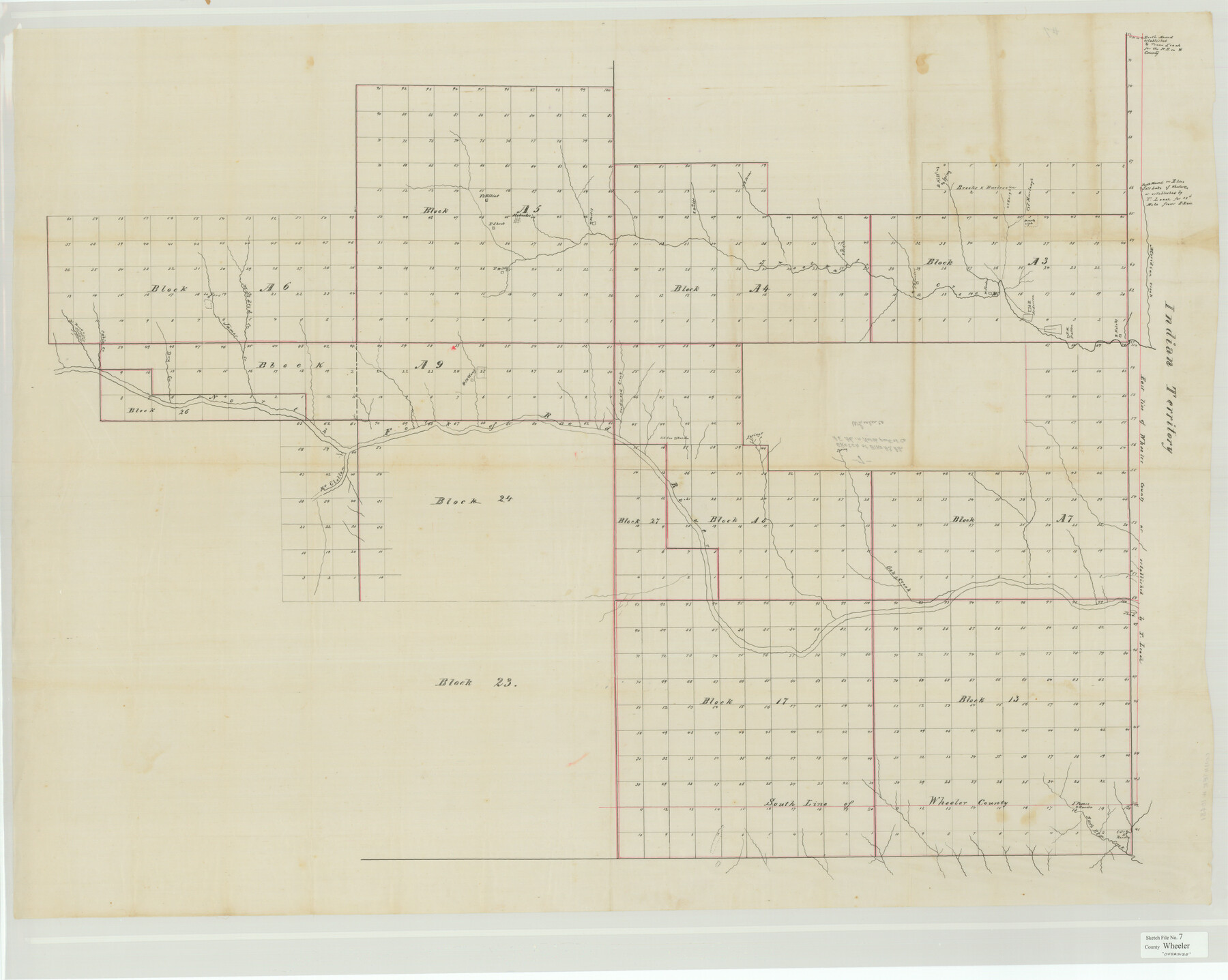
Wheeler County Sketch File 7
[Sketch of Blocks A3, A4, A5, A6, A7, A8, A9, 13, 17, 26, and 27]
-
Map/Doc
10431
-
Collection
General Map Collection
-
Counties
Wheeler Collingsworth
-
Subjects
Surveying Sketch File
-
Height x Width
38.1 x 47.7 inches
96.8 x 121.2 cm
-
Medium
paper, manuscript
-
Features
Salt Lake
Sweetwater Creek
Mobeetie
Mildred's Creek
James Creek
Dry Creek
Cabin Creek
North Fork of Red River
Cordwood Creek
Meridian Creek
Old Cow Ranch
McClellon Creek
Oak Creek
North Elm Creek
Part of: General Map Collection
South Part of Webb County

Print $40.00
- Digital $50.00
South Part of Webb County
1984
Size 43.5 x 63.9 inches
Map/Doc 73320
Intracoastal Waterway - Laguna Madre - Chubby Island to Stover Point including the Arroyo Colorado, Texas

Print $20.00
- Digital $50.00
Intracoastal Waterway - Laguna Madre - Chubby Island to Stover Point including the Arroyo Colorado, Texas
1976
Size 15.6 x 43.8 inches
Map/Doc 75900
Gregg County Working Sketch 12

Print $20.00
- Digital $50.00
Gregg County Working Sketch 12
1940
Size 11.0 x 18.9 inches
Map/Doc 63279
Sterling County Sketch File 6

Print $12.00
- Digital $50.00
Sterling County Sketch File 6
1912
Size 5.7 x 8.8 inches
Map/Doc 37115
Palo Pinto County Working Sketch 18

Print $20.00
- Digital $50.00
Palo Pinto County Working Sketch 18
1974
Size 30.5 x 37.3 inches
Map/Doc 71401
Galveston Bay and Approaches

Print $20.00
- Digital $50.00
Galveston Bay and Approaches
1966
Size 43.3 x 32.6 inches
Map/Doc 69879
Kimble County Rolled Sketch 35

Print $20.00
- Digital $50.00
Kimble County Rolled Sketch 35
1978
Size 20.0 x 19.6 inches
Map/Doc 6525
Maps of Gulf Intracoastal Waterway, Texas - Sabine River to the Rio Grande and connecting waterways including ship channels

Print $20.00
- Digital $50.00
Maps of Gulf Intracoastal Waterway, Texas - Sabine River to the Rio Grande and connecting waterways including ship channels
1966
Size 14.3 x 20.7 inches
Map/Doc 61998

San Patricio County NRC Article 33.136 Sketch 4A

Print $3.00
- Digital $50.00
San Patricio County NRC Article 33.136 Sketch 4A
Size 17.0 x 11.0 inches
Map/Doc 94696
Map of Baylor County Young Land District, formely Fannin District

Print $20.00
- Digital $50.00
Map of Baylor County Young Land District, formely Fannin District
1859
Size 25.8 x 20.0 inches
Map/Doc 3281
Goliad County Sketch File 22

Print $12.00
- Digital $50.00
Goliad County Sketch File 22
1855
Size 12.8 x 8.1 inches
Map/Doc 24289
You may also like
Live Oak County Working Sketch 25

Print $3.00
- Digital $50.00
Live Oak County Working Sketch 25
1980
Size 16.7 x 10.6 inches
Map/Doc 70610
Newton County Sketch File 13

Print $22.00
- Digital $50.00
Newton County Sketch File 13
Size 8.1 x 12.7 inches
Map/Doc 32386

San Saba County

Print $20.00
- Digital $50.00
San Saba County
1918
Size 46.8 x 41.2 inches
Map/Doc 63022
Marion County Rolled Sketch 2

Print $20.00
- Digital $50.00
Marion County Rolled Sketch 2
1954
Size 34.8 x 45.9 inches
Map/Doc 46621
Uvalde County Working Sketch Graphic Index

Print $20.00
- Digital $50.00
Uvalde County Working Sketch Graphic Index
1976
Size 42.5 x 46.2 inches
Map/Doc 76723
A Map of the British Empire in North America

Print $20.00
- Digital $50.00
A Map of the British Empire in North America
1774
Size 22.1 x 15.1 inches
Map/Doc 93733
Hudspeth County Sketch File 33

Print $6.00
- Digital $50.00
Hudspeth County Sketch File 33
1952
Size 11.3 x 8.8 inches
Map/Doc 26994
Map of Swisher Addition

Print $20.00
- Digital $50.00
Map of Swisher Addition
1910
Size 18.0 x 13.1 inches
Map/Doc 83425
Runnels County Sketch File 26

Print $20.00
Runnels County Sketch File 26
1949
Size 20.0 x 18.8 inches
Map/Doc 12260
Map of Glasscock County

Print $20.00
- Digital $50.00
Map of Glasscock County
Size 19.1 x 23.1 inches
Map/Doc 90781
Sterling County Working Sketch 6

Print $40.00
- Digital $50.00
Sterling County Working Sketch 6
1955
Size 38.1 x 121.6 inches
Map/Doc 63988