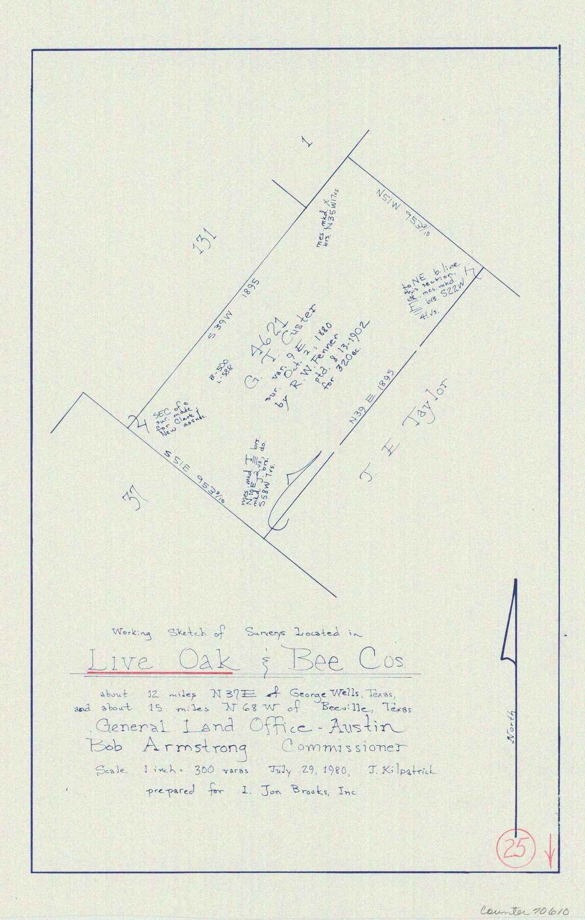
Live Oak County Working Sketch 25
-
Map/Doc
70610
-
Collection
General Map Collection
-
Object Dates
7/29/1980 (Creation Date)
-
People and Organizations
Joan Kilpatrick (Draftsman)
-
Counties
Live Oak Bee
-
Subjects
Surveying Working Sketch
-
Height x Width
16.7 x 10.6 inches
42.4 x 26.9 cm
-
Scale
1" = 300 varas
Part of: General Map Collection
Hunt County Boundary File 2b

Print $2.00
- Digital $50.00
Hunt County Boundary File 2b
Size 12.8 x 7.9 inches
Map/Doc 55207
Deaf Smith County Sketch File 1a

Print $21.00
- Digital $50.00
Deaf Smith County Sketch File 1a
Size 11.5 x 9.2 inches
Map/Doc 20616
Grayson County Boundary File 1a

Print $120.00
- Digital $50.00
Grayson County Boundary File 1a
Size 69.3 x 11.3 inches
Map/Doc 53928
Jeff Davis County Rolled Sketch 12

Print $20.00
- Digital $50.00
Jeff Davis County Rolled Sketch 12
1920
Size 24.8 x 18.1 inches
Map/Doc 6365
[Cotton Belt, St. Louis Southwestern Railway of Texas, Alignment through Smith County]
![64376, [Cotton Belt, St. Louis Southwestern Railway of Texas, Alignment through Smith County], General Map Collection](https://historictexasmaps.com/wmedia_w700/maps/64376-1.tif.jpg)
Print $20.00
- Digital $50.00
[Cotton Belt, St. Louis Southwestern Railway of Texas, Alignment through Smith County]
1903
Size 22.0 x 29.3 inches
Map/Doc 64376
Map of Duval County

Print $20.00
- Digital $50.00
Map of Duval County
1876
Size 29.6 x 21.5 inches
Map/Doc 3498
Howard County Rolled Sketch 2

Print $20.00
- Digital $50.00
Howard County Rolled Sketch 2
1905
Size 27.6 x 23.0 inches
Map/Doc 6232
Brewster County Working Sketch 109

Print $20.00
- Digital $50.00
Brewster County Working Sketch 109
1981
Size 25.2 x 37.0 inches
Map/Doc 67709
Hockley County Sketch File 9

Print $40.00
- Digital $50.00
Hockley County Sketch File 9
1912
Size 48.2 x 12.8 inches
Map/Doc 10491
Chicago, Rock Island, Texas & Mexico

Print $40.00
- Digital $50.00
Chicago, Rock Island, Texas & Mexico
1920
Size 25.9 x 120.3 inches
Map/Doc 64422
Martin County Rolled Sketch 6

Print $20.00
- Digital $50.00
Martin County Rolled Sketch 6
Size 25.8 x 26.9 inches
Map/Doc 6666
Map of Location and Right of Way from El Paso, Tex. To New Mexico Line, Rio Grande & El Paso R.R.

Print $20.00
- Digital $50.00
Map of Location and Right of Way from El Paso, Tex. To New Mexico Line, Rio Grande & El Paso R.R.
Size 14.0 x 20.9 inches
Map/Doc 64085
You may also like

Gaines County Rolled Sketch J

Print $40.00
- Digital $50.00
Gaines County Rolled Sketch J
Size 26.6 x 73.8 inches
Map/Doc 9013

Wichita County Working Sketch 1

Print $20.00
- Digital $50.00
Wichita County Working Sketch 1
Size 23.5 x 24.2 inches
Map/Doc 72510
W. L. Ellwood's O Ranch, Lubbock and Hockley Co.

Print $20.00
- Digital $50.00
W. L. Ellwood's O Ranch, Lubbock and Hockley Co.
Size 15.5 x 23.8 inches
Map/Doc 92762
Matagorda County Sketch File 1

Print $4.00
- Digital $50.00
Matagorda County Sketch File 1
1876
Size 13.0 x 8.8 inches
Map/Doc 30728
Newton County Sketch File 42

Print $39.00
- Digital $50.00
Newton County Sketch File 42
1936
Size 13.2 x 8.7 inches
Map/Doc 32425
Wharton County Rolled Sketch 5

Print $20.00
- Digital $50.00
Wharton County Rolled Sketch 5
1899
Size 19.3 x 24.6 inches
Map/Doc 8229
Bexar County Rolled Sketch 5

Print $20.00
- Digital $50.00
Bexar County Rolled Sketch 5
1984
Size 24.3 x 18.6 inches
Map/Doc 5140
Live Oak County Working Sketch 9

Print $20.00
- Digital $50.00
Live Oak County Working Sketch 9
1938
Size 35.7 x 41.1 inches
Map/Doc 70594
General Homes Free Houston Area Map

General Homes Free Houston Area Map
Size 27.1 x 42.5 inches
Map/Doc 94393
[Caddo Lake & Subdivisions]
![2896, [Caddo Lake & Subdivisions], General Map Collection](https://historictexasmaps.com/wmedia_w700/maps/2896-1.tif.jpg)
Print $20.00
- Digital $50.00
[Caddo Lake & Subdivisions]
1918
Size 31.3 x 28.6 inches
Map/Doc 2896