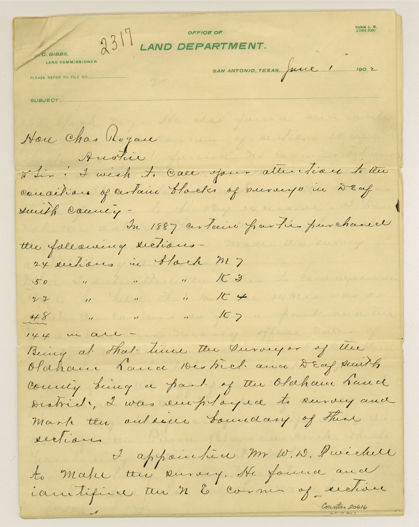
Deaf Smith County Sketch File 1a
[Letter and explanation of Capitol Syndicate Blocks K-3, K-4, K-5, K-6, K-7, K-8]
-
Map/Doc
20616
-
Collection
General Map Collection
-
Object Dates
1916/7/16 (File Date)
-
People and Organizations
W.D. Twichell (Surveyor/Engineer)
-
Counties
Deaf Smith
-
Subjects
Surveying Sketch File
-
Height x Width
11.5 x 9.2 inches
29.2 x 23.4 cm
-
Medium
multi-page, multi-format
-
Features
Tierra Blanca Creek
Part of: General Map Collection
A Survey of Lake Champlain, including Lake George, Crown Point and St. John

Print $20.00
- Digital $50.00
A Survey of Lake Champlain, including Lake George, Crown Point and St. John
1762
Size 29.0 x 20.9 inches
Map/Doc 97404
Motley County Boundary File 2c

Print $34.00
- Digital $50.00
Motley County Boundary File 2c
Size 14.2 x 8.7 inches
Map/Doc 57533
Wharton County Sketch File A2

Print $32.00
- Digital $50.00
Wharton County Sketch File A2
1898
Size 22.1 x 15.7 inches
Map/Doc 12670
Haskell County Working Sketch 14

Print $20.00
- Digital $50.00
Haskell County Working Sketch 14
1983
Size 34.2 x 40.7 inches
Map/Doc 66072
Cameron County Rolled Sketch 5

Print $20.00
- Digital $50.00
Cameron County Rolled Sketch 5
Size 35.8 x 38.8 inches
Map/Doc 8562
Jim Wells County Working Sketch 8

Print $20.00
- Digital $50.00
Jim Wells County Working Sketch 8
1947
Size 23.8 x 26.0 inches
Map/Doc 66606
Cameron County Rolled Sketch Z5

Print $20.00
- Digital $50.00
Cameron County Rolled Sketch Z5
1937
Size 28.7 x 33.6 inches
Map/Doc 5403
Lubbock County

Print $20.00
- Digital $50.00
Lubbock County
1892
Size 20.1 x 19.3 inches
Map/Doc 3828
Zapata County Working Sketch 5

Print $20.00
- Digital $50.00
Zapata County Working Sketch 5
1940
Size 23.4 x 18.3 inches
Map/Doc 62056
Flight Mission No. CRC-2R, Frame 53, Chambers County

Print $20.00
- Digital $50.00
Flight Mission No. CRC-2R, Frame 53, Chambers County
1956
Size 18.5 x 22.4 inches
Map/Doc 84726
Polk County Sketch File 30b

Print $4.00
- Digital $50.00
Polk County Sketch File 30b
Size 6.5 x 7.9 inches
Map/Doc 34219
Brazoria County Working Sketch 21

Print $20.00
- Digital $50.00
Brazoria County Working Sketch 21
1954
Size 41.5 x 41.8 inches
Map/Doc 67506
You may also like
Shackelford County Boundary File 6

Print $6.00
- Digital $50.00
Shackelford County Boundary File 6
Size 11.4 x 8.8 inches
Map/Doc 58668
Rains County Rolled Sketch 1

Print $40.00
- Digital $50.00
Rains County Rolled Sketch 1
1958
Size 42.0 x 65.2 inches
Map/Doc 9806
Baylor County Sketch File 23a

Print $10.00
- Digital $50.00
Baylor County Sketch File 23a
1927
Size 14.3 x 8.9 inches
Map/Doc 14204
[Surveys on the waters of Pine Creeke of the Neches]
![348, [Surveys on the waters of Pine Creeke of the Neches], General Map Collection](https://historictexasmaps.com/wmedia_w700/maps/348.tif.jpg)
Print $2.00
- Digital $50.00
[Surveys on the waters of Pine Creeke of the Neches]
1845
Size 7.9 x 8.2 inches
Map/Doc 348
[Movements & Objectives of the 143rd & 144th Infantry and many other divisions and regiments, 1918]
![94138, [Movements & Objectives of the 143rd & 144th Infantry and many other divisions and regiments, 1918], Non-GLO Digital Images](https://historictexasmaps.com/wmedia_w700/maps/94138-1.tif.jpg)
Print $40.00
[Movements & Objectives of the 143rd & 144th Infantry and many other divisions and regiments, 1918]
1918
Size 64.2 x 37.5 inches
Map/Doc 94138
Shackelford County Sketch File 9

Print $20.00
- Digital $50.00
Shackelford County Sketch File 9
1918
Size 24.3 x 15.5 inches
Map/Doc 12315
Leon County Sketch File 20

Print $6.00
- Digital $50.00
Leon County Sketch File 20
Size 10.6 x 10.0 inches
Map/Doc 29770
Fayette County Boundary File 6

Print $20.00
- Digital $50.00
Fayette County Boundary File 6
Size 14.4 x 9.0 inches
Map/Doc 53391
Hays County Working Sketch 4

Print $20.00
- Digital $50.00
Hays County Working Sketch 4
1928
Size 25.4 x 21.7 inches
Map/Doc 66078
Cameron County Working Sketch Graphic Index

Print $20.00
- Digital $50.00
Cameron County Working Sketch Graphic Index
1976
Size 32.0 x 39.4 inches
Map/Doc 76486
McCulloch County Sketch File 13

Print $4.00
- Digital $50.00
McCulloch County Sketch File 13
1982
Size 3.4 x 7.8 inches
Map/Doc 31201
Real County Working Sketch 82

Print $20.00
- Digital $50.00
Real County Working Sketch 82
1985
Size 24.9 x 23.5 inches
Map/Doc 71974