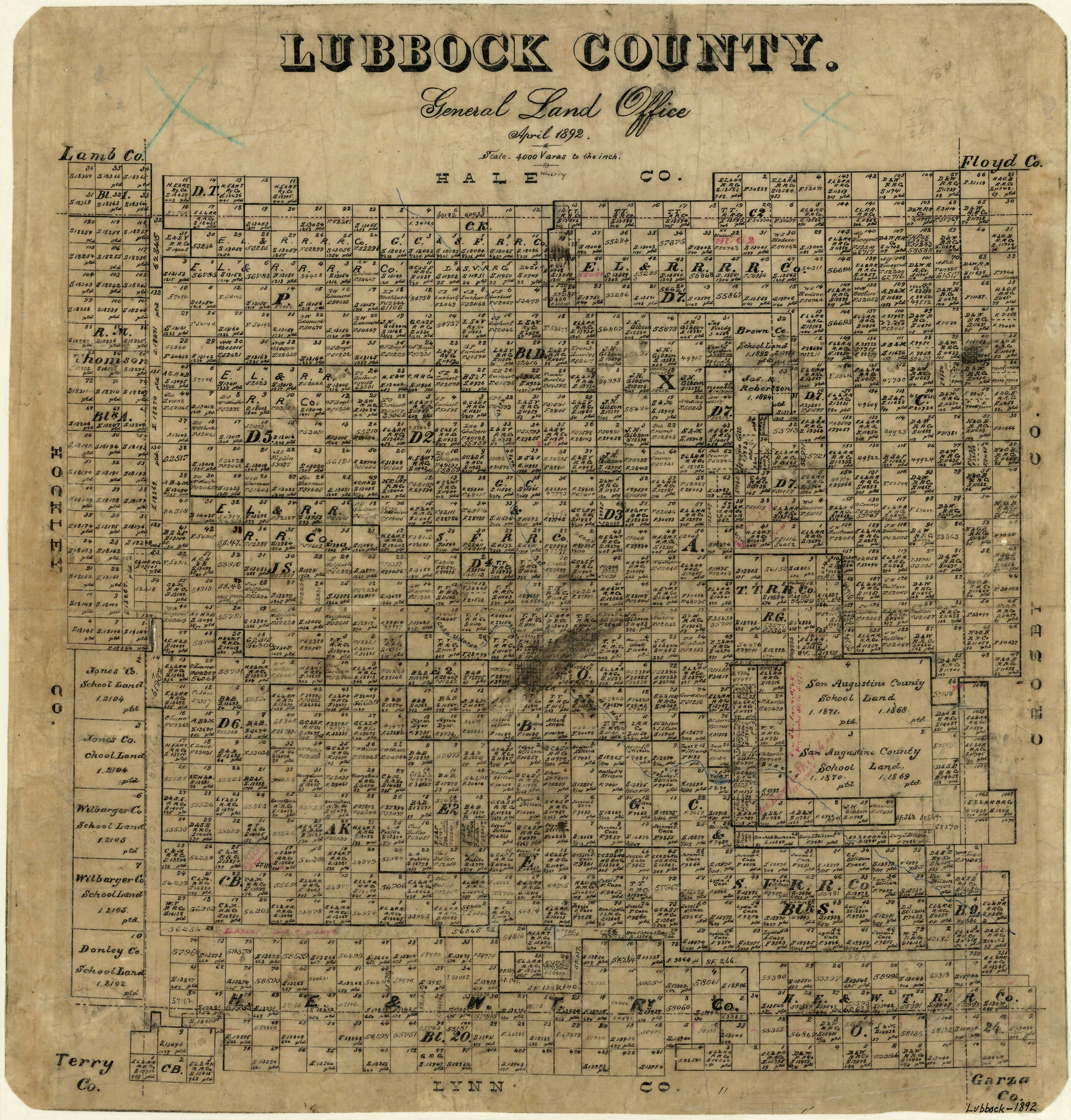
Lubbock County
-
Map/Doc
3828
-
Collection
General Map Collection
-
Object Dates
4/1892 (Creation Date)
-
People and Organizations
Murray (Draftsman)
-
Counties
Lubbock
-
Subjects
County
-
Height x Width
20.1 x 19.3 inches
51.1 x 49.0 cm
-
Features
Estacado
North Fork [of Brazos River]
Yellow House Creek
Double Mountain Fork of Brazos River
Lubbock
Casa Marea Creek
Part of: General Map Collection
Frio County Working Sketch 17

Print $20.00
- Digital $50.00
Frio County Working Sketch 17
1980
Size 14.4 x 16.8 inches
Map/Doc 69291
Cooke County Boundary File 3

Print $4.00
- Digital $50.00
Cooke County Boundary File 3
Size 7.3 x 8.7 inches
Map/Doc 51853
Nueces County NRC Article 33.136 Location Key Sheet

Print $20.00
- Digital $50.00
Nueces County NRC Article 33.136 Location Key Sheet
1975
Size 27.0 x 23.0 inches
Map/Doc 88586
Knox County Sketch File 23

Print $20.00
- Digital $50.00
Knox County Sketch File 23
1931
Size 21.4 x 15.3 inches
Map/Doc 11963
Il Cuscho Citta Principale Della Provincia del Peru

Print $20.00
- Digital $50.00
Il Cuscho Citta Principale Della Provincia del Peru
1592
Size 12.3 x 15.4 inches
Map/Doc 97026
Presidio County Working Sketch 43

Print $40.00
- Digital $50.00
Presidio County Working Sketch 43
1949
Size 29.0 x 54.9 inches
Map/Doc 71720
San Jacinto County Rolled Sketch 14

Print $20.00
- Digital $50.00
San Jacinto County Rolled Sketch 14
1998
Size 28.1 x 40.0 inches
Map/Doc 7564
Bandera County

Print $40.00
- Digital $50.00
Bandera County
1947
Size 33.7 x 54.2 inches
Map/Doc 77207
Hutchinson County Sketch File 31

Print $20.00
- Digital $50.00
Hutchinson County Sketch File 31
Size 19.9 x 15.2 inches
Map/Doc 11819
Baylor County Sketch File 1a

Print $8.00
- Digital $50.00
Baylor County Sketch File 1a
1857
Size 8.2 x 7.9 inches
Map/Doc 14144
Crockett County Rolled Sketch 58

Print $20.00
- Digital $50.00
Crockett County Rolled Sketch 58
Size 19.0 x 32.8 inches
Map/Doc 5600
Briscoe County Sketch File 8

Print $6.00
- Digital $50.00
Briscoe County Sketch File 8
1896
Size 10.5 x 8.3 inches
Map/Doc 16417
You may also like
Flight Mission No. BRE-1P, Frame 54, Nueces County

Print $20.00
- Digital $50.00
Flight Mission No. BRE-1P, Frame 54, Nueces County
1956
Size 18.4 x 22.2 inches
Map/Doc 86643
Flight Mission No. BRA-16M, Frame 162, Jefferson County

Print $20.00
- Digital $50.00
Flight Mission No. BRA-16M, Frame 162, Jefferson County
1953
Size 18.6 x 22.3 inches
Map/Doc 85760
Flight Mission No. DIX-6P, Frame 131, Aransas County

Print $20.00
- Digital $50.00
Flight Mission No. DIX-6P, Frame 131, Aransas County
1956
Size 19.5 x 23.0 inches
Map/Doc 83837
Brazoria County NRC Article 33.136 Sketch 6

Print $22.00
- Digital $50.00
Brazoria County NRC Article 33.136 Sketch 6
2004
Size 24.6 x 35.2 inches
Map/Doc 82904
Newton County Working Sketch 18

Print $20.00
- Digital $50.00
Newton County Working Sketch 18
1950
Size 14.3 x 13.6 inches
Map/Doc 71264
Hamilton County

Print $20.00
- Digital $50.00
Hamilton County
1916
Size 41.4 x 40.5 inches
Map/Doc 66851
El Paso County Sketch File 11

Print $6.00
- Digital $50.00
El Paso County Sketch File 11
Size 14.2 x 11.0 inches
Map/Doc 22000
Flight Mission No. BRE-1P, Frame 70, Nueces County

Print $20.00
- Digital $50.00
Flight Mission No. BRE-1P, Frame 70, Nueces County
1956
Size 18.3 x 22.1 inches
Map/Doc 86652
The Republic County of Gonzales. May 24, 1838

Print $20.00
The Republic County of Gonzales. May 24, 1838
2020
Size 14.7 x 21.7 inches
Map/Doc 96156
Current Miscellaneous File 110

Print $62.00
- Digital $50.00
Current Miscellaneous File 110
1972
Size 11.1 x 8.8 inches
Map/Doc 74713
Atascosa County Working Sketch 22

Print $20.00
- Digital $50.00
Atascosa County Working Sketch 22
1956
Size 31.6 x 25.5 inches
Map/Doc 67218