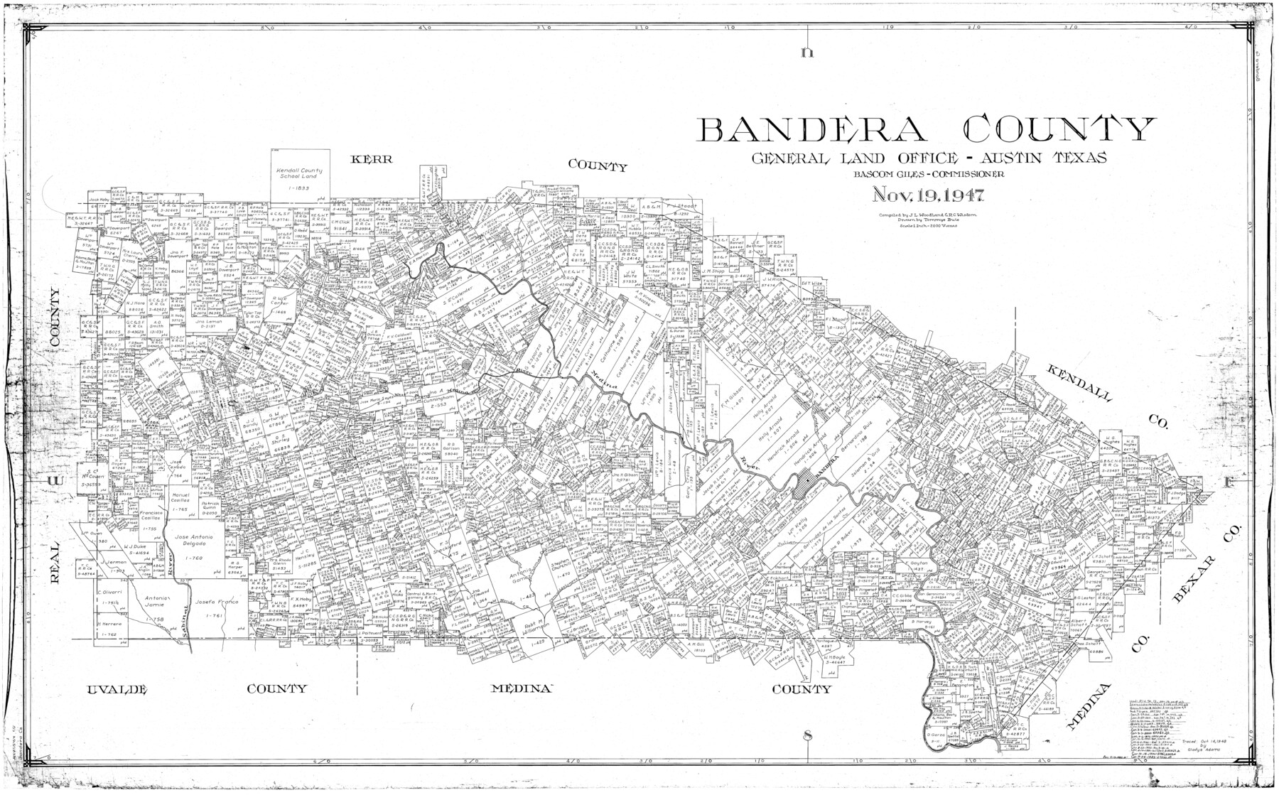
Bandera County
-
Map/Doc
77207
-
Collection
General Map Collection
-
Object Dates
1947/11/19 (Creation Date)
-
People and Organizations
General Land Office (Publisher)
Bascom Giles (GLO Commissioner)
Tommye Buie (Draftsman)
J.L. Woodland (Compiler)
R.C. Wisdom (Compiler)
-
Counties
Bandera
-
Subjects
County
-
Height x Width
33.7 x 54.2 inches
85.6 x 137.7 cm
Part of: General Map Collection
Hockley County Rolled Sketch 3

Print $40.00
- Digital $50.00
Hockley County Rolled Sketch 3
Size 82.9 x 29.4 inches
Map/Doc 9173
Flight Mission No. DQN-7K, Frame 15, Calhoun County

Print $20.00
- Digital $50.00
Flight Mission No. DQN-7K, Frame 15, Calhoun County
1953
Size 18.4 x 22.1 inches
Map/Doc 84466
Pecos County Working Sketch 35

Print $20.00
- Digital $50.00
Pecos County Working Sketch 35
1939
Size 32.5 x 26.7 inches
Map/Doc 71507
Walker County Working Sketch 18

Print $20.00
- Digital $50.00
Walker County Working Sketch 18
1991
Size 29.4 x 31.5 inches
Map/Doc 72298
Starr County Sketch File 17

Print $24.00
- Digital $50.00
Starr County Sketch File 17
1880
Size 12.8 x 8.2 inches
Map/Doc 36874
Goliad County Working Sketch 22

Print $20.00
- Digital $50.00
Goliad County Working Sketch 22
1971
Size 33.1 x 36.8 inches
Map/Doc 63212
Liberty County Working Sketch 23

Print $20.00
- Digital $50.00
Liberty County Working Sketch 23
1941
Size 29.9 x 26.4 inches
Map/Doc 70482
Polk County Sketch File 28

Print $4.00
- Digital $50.00
Polk County Sketch File 28
Size 8.6 x 9.9 inches
Map/Doc 34198
Jackson County Rolled Sketch 3A

Print $20.00
- Digital $50.00
Jackson County Rolled Sketch 3A
1913
Size 23.2 x 22.6 inches
Map/Doc 6337
Shelby County Rolled Sketch 2

Print $20.00
- Digital $50.00
Shelby County Rolled Sketch 2
Size 20.3 x 30.7 inches
Map/Doc 7775
McMullen County Working Sketch 26

Print $20.00
- Digital $50.00
McMullen County Working Sketch 26
1953
Size 17.8 x 14.5 inches
Map/Doc 70727

You may also like
The Republic County of Galveston. December 29, 1845

Print $20.00
The Republic County of Galveston. December 29, 1845
2020
Size 14.7 x 21.9 inches
Map/Doc 96146
Haskell County Sketch File 15

Print $24.00
- Digital $50.00
Haskell County Sketch File 15
1893
Size 13.5 x 16.5 inches
Map/Doc 26158
Texas in 1840, or the Emigrant's Guide to the New Republic; being the result of observation, enquiry and travel in that beautiful country

Texas in 1840, or the Emigrant's Guide to the New Republic; being the result of observation, enquiry and travel in that beautiful country
1840
Map/Doc 97198
Maps & Lists Showing Prison Lands (Oil & Gas) Leased as of June 1955

Digital $50.00
Maps & Lists Showing Prison Lands (Oil & Gas) Leased as of June 1955
1934
Size 35.6 x 32.3 inches
Map/Doc 62879
Angelina County Sketch File 11b

Print $6.00
- Digital $50.00
Angelina County Sketch File 11b
1859
Size 17.7 x 8.3 inches
Map/Doc 12944
Hood County Working Sketch 20

Print $20.00
- Digital $50.00
Hood County Working Sketch 20
1989
Size 39.6 x 34.7 inches
Map/Doc 66214
Edwards County Working Sketch 68

Print $20.00
- Digital $50.00
Edwards County Working Sketch 68
1957
Size 28.7 x 26.8 inches
Map/Doc 68944
Red River County, Texas

Print $20.00
- Digital $50.00
Red River County, Texas
1879
Size 29.3 x 21.9 inches
Map/Doc 598
Brazoria County

Print $20.00
- Digital $50.00
Brazoria County
1879
Size 27.0 x 25.1 inches
Map/Doc 4647
T. & N. O. RR. Company, Block 1

Print $20.00
- Digital $50.00
T. & N. O. RR. Company, Block 1
Size 35.3 x 19.5 inches
Map/Doc 90740
Hardin County Sketch File 17

Print $6.00
- Digital $50.00
Hardin County Sketch File 17
1854
Size 15.9 x 9.9 inches
Map/Doc 25130
Hardeman County Working Sketch 3

Print $20.00
- Digital $50.00
Hardeman County Working Sketch 3
1919
Size 32.7 x 35.1 inches
Map/Doc 63384