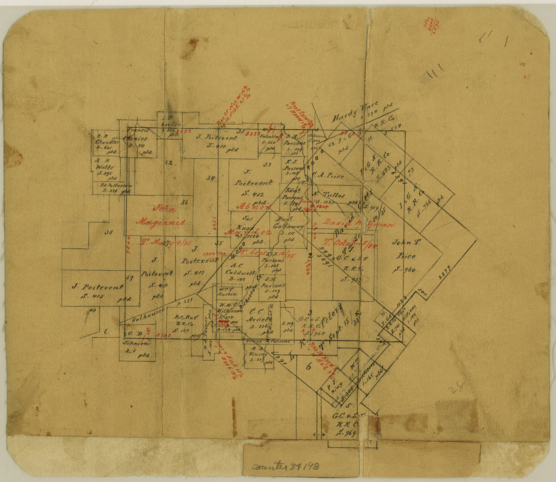
Polk County Sketch File 28
[Office sketch showing surveys in conflict with L. K. Peters and D. Cutts]
-
Map/Doc
34198
-
Collection
General Map Collection
-
People and Organizations
Pressler (Surveyor/Engineer)
-
Counties
Polk
-
Subjects
Surveying Sketch File
-
Height x Width
8.6 x 9.9 inches
21.8 x 25.1 cm
-
Medium
paper, manuscript
-
Features
Dickerson Creek
Part of: General Map Collection
Map of the Lands Surveyed by the Memphis, El Paso & Pacific R.R. Company

Print $20.00
- Digital $50.00
Map of the Lands Surveyed by the Memphis, El Paso & Pacific R.R. Company
1860
Size 20.1 x 20.8 inches
Map/Doc 4848
La Salle County

Print $20.00
- Digital $50.00
La Salle County
1923
Size 39.7 x 34.5 inches
Map/Doc 77348
Kendall County Working Sketch 8

Print $20.00
- Digital $50.00
Kendall County Working Sketch 8
1951
Size 24.5 x 25.0 inches
Map/Doc 66680
Fannin County Rolled Sketch 18A

Print $20.00
- Digital $50.00
Fannin County Rolled Sketch 18A
Size 15.1 x 33.6 inches
Map/Doc 5868
Roberts County Working Sketch 13

Print $20.00
- Digital $50.00
Roberts County Working Sketch 13
1971
Size 20.2 x 16.0 inches
Map/Doc 63539
Amistad International Reservoir on Rio Grande 82

Print $20.00
- Digital $50.00
Amistad International Reservoir on Rio Grande 82
1949
Size 28.5 x 40.2 inches
Map/Doc 75511
Jack County Sketch File 31

Print $40.00
- Digital $50.00
Jack County Sketch File 31
1926
Size 8.8 x 7.2 inches
Map/Doc 27565
Swisher County

Print $20.00
- Digital $50.00
Swisher County
1879
Size 20.9 x 18.7 inches
Map/Doc 4063
Eastland County Working Sketch 10

Print $20.00
- Digital $50.00
Eastland County Working Sketch 10
1919
Size 20.2 x 16.3 inches
Map/Doc 68791
Hardin County Working Sketch 26

Print $20.00
- Digital $50.00
Hardin County Working Sketch 26
1954
Size 19.5 x 23.8 inches
Map/Doc 63424
Flight Mission No. CRC-3R, Frame 47, Chambers County

Print $20.00
- Digital $50.00
Flight Mission No. CRC-3R, Frame 47, Chambers County
1956
Size 18.6 x 22.3 inches
Map/Doc 84820
Ward County Working Sketch 52

Print $20.00
- Digital $50.00
Ward County Working Sketch 52
1980
Size 36.3 x 37.0 inches
Map/Doc 72358
You may also like
Lamb County Boundary File 1d

Print $6.00
- Digital $50.00
Lamb County Boundary File 1d
Size 10.2 x 8.2 inches
Map/Doc 56051
Outer Continental Shelf Leasing Maps (Texas Offshore Operations)

Print $20.00
- Digital $50.00
Outer Continental Shelf Leasing Maps (Texas Offshore Operations)
Size 23.4 x 13.0 inches
Map/Doc 75854
Taylor County Sketch File 21

Print $10.00
- Digital $50.00
Taylor County Sketch File 21
1962
Size 11.3 x 8.8 inches
Map/Doc 37821
The Republic County of Houston. Spring 1842

Print $20.00
The Republic County of Houston. Spring 1842
2020
Size 19.7 x 21.8 inches
Map/Doc 96182
The Scarborough Company's New Railroad, Post Office & County Map of Texas, Oklahoma and Indian Territory Compiled from the Latest Government Surveys and Original Sources

Print $20.00
- Digital $50.00
The Scarborough Company's New Railroad, Post Office & County Map of Texas, Oklahoma and Indian Territory Compiled from the Latest Government Surveys and Original Sources
1904
Size 42.8 x 46.6 inches
Map/Doc 93911
[Resurvey of Block Number 01- W. H. Godair Surveys]
![92585, [Resurvey of Block Number 01- W. H. Godair Surveys], Twichell Survey Records](https://historictexasmaps.com/wmedia_w700/maps/92585-1.tif.jpg)
Print $20.00
- Digital $50.00
[Resurvey of Block Number 01- W. H. Godair Surveys]
1923
Size 33.9 x 14.9 inches
Map/Doc 92585
Wichita County Working Sketch 9

Print $20.00
- Digital $50.00
Wichita County Working Sketch 9
1920
Size 23.7 x 17.6 inches
Map/Doc 72518
Map of Goliad County Texas

Print $20.00
- Digital $50.00
Map of Goliad County Texas
1879
Size 19.5 x 21.8 inches
Map/Doc 4548
Van Zandt County Sketch File 47a

Print $7.00
- Digital $50.00
Van Zandt County Sketch File 47a
1875
Size 10.0 x 8.2 inches
Map/Doc 39507
Fisher County, Texas

Print $20.00
- Digital $50.00
Fisher County, Texas
1870
Size 22.5 x 17.6 inches
Map/Doc 726
Reeves County Rolled Sketch N

Print $40.00
- Digital $50.00
Reeves County Rolled Sketch N
Size 44.5 x 74.7 inches
Map/Doc 9846
Haskell County Working Sketch 14

Print $20.00
- Digital $50.00
Haskell County Working Sketch 14
1983
Size 34.2 x 40.7 inches
Map/Doc 66072