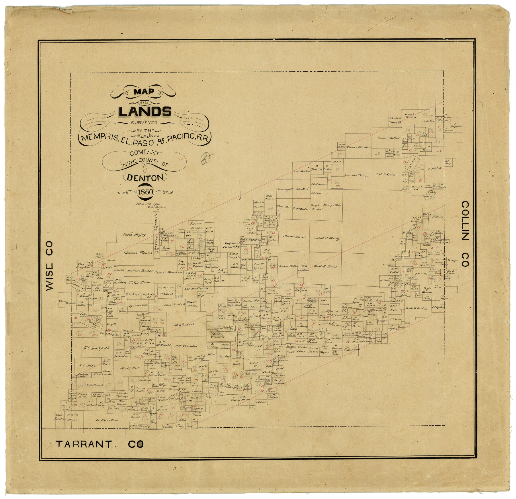
Map of the Lands Surveyed by the Memphis, El Paso & Pacific R.R. Company
T-1-12
-
Map/Doc
4848
-
Collection
General Map Collection
-
Object Dates
1860 (Creation Date)
-
Counties
Denton
-
Subjects
Railroads
-
Height x Width
20.1 x 20.8 inches
51.1 x 52.8 cm
-
Comments
Became Texas and Pacific Railway Company in 1873.
Adopted with contributions from the State Employee Charitable Campaign (SECC) and conservation funded in 2011.
Part of: General Map Collection
United States - Gulf Coast - Galveston to Rio Grande

Print $20.00
- Digital $50.00
United States - Gulf Coast - Galveston to Rio Grande
1941
Size 27.0 x 18.2 inches
Map/Doc 72754
Flight Mission No. DIX-8P, Frame 62, Aransas County

Print $20.00
- Digital $50.00
Flight Mission No. DIX-8P, Frame 62, Aransas County
1956
Size 18.5 x 22.2 inches
Map/Doc 83893
Val Verde County Rolled Sketch 58

Print $20.00
- Digital $50.00
Val Verde County Rolled Sketch 58
1938
Size 17.9 x 22.4 inches
Map/Doc 8126
Flight Mission No. DQO-11K, Frame 23, Galveston County

Print $20.00
- Digital $50.00
Flight Mission No. DQO-11K, Frame 23, Galveston County
1952
Size 18.8 x 22.4 inches
Map/Doc 85220
Fannin County Boundary File 2

Print $27.00
- Digital $50.00
Fannin County Boundary File 2
Size 13.4 x 8.8 inches
Map/Doc 53282
Copy of Surveyor's Field Book, Morris Browning - In Blocks 7, 5 & 4, I&GNRRCo., Hutchinson and Carson Counties, Texas

Print $2.00
- Digital $50.00
Copy of Surveyor's Field Book, Morris Browning - In Blocks 7, 5 & 4, I&GNRRCo., Hutchinson and Carson Counties, Texas
1888
Size 6.9 x 8.8 inches
Map/Doc 62263
Zavala County

Print $20.00
- Digital $50.00
Zavala County
1977
Size 36.6 x 41.6 inches
Map/Doc 77468
Map of Potter County

Print $20.00
- Digital $50.00
Map of Potter County
1895
Size 27.0 x 21.1 inches
Map/Doc 3966
United States Atlantic and Gulf Coasts Including Puerto Rico and the Virgin Islands

Print $40.00
- Digital $50.00
United States Atlantic and Gulf Coasts Including Puerto Rico and the Virgin Islands
1992
Size 21.7 x 60.7 inches
Map/Doc 76123
Blanco County Working Sketch 39

Print $20.00
- Digital $50.00
Blanco County Working Sketch 39
1985
Size 11.9 x 18.4 inches
Map/Doc 67399
Sectional Map No. 2 of the lands and the line of the Texas & Pacific Ry. Co. in Howard, Martin, Andrews, Midland and Tom Green Counties

Print $20.00
- Digital $50.00
Sectional Map No. 2 of the lands and the line of the Texas & Pacific Ry. Co. in Howard, Martin, Andrews, Midland and Tom Green Counties
1885
Size 18.9 x 23.4 inches
Map/Doc 4859
Kerr County Sketch File 6b

Print $4.00
- Digital $50.00
Kerr County Sketch File 6b
1880
Size 8.5 x 13.6 inches
Map/Doc 28867
You may also like
Travis County Boundary File 4a

Print $40.00
- Digital $50.00
Travis County Boundary File 4a
Size 27.9 x 17.8 inches
Map/Doc 59428
Haskell County Working Sketch 14

Print $20.00
- Digital $50.00
Haskell County Working Sketch 14
1983
Size 34.2 x 40.7 inches
Map/Doc 66072
Foard County Rolled Sketch 14 1/2

Print $20.00
- Digital $50.00
Foard County Rolled Sketch 14 1/2
1888
Size 20.8 x 37.4 inches
Map/Doc 5889
Brewster County Rolled Sketch 107

Print $20.00
- Digital $50.00
Brewster County Rolled Sketch 107
Size 22.2 x 11.2 inches
Map/Doc 5259
Archer County Working Sketch 3

Print $20.00
- Digital $50.00
Archer County Working Sketch 3
1913
Size 19.8 x 12.3 inches
Map/Doc 67143
Lipscomb County Boundary File 14a

Print $4.00
- Digital $50.00
Lipscomb County Boundary File 14a
Size 11.3 x 8.7 inches
Map/Doc 56368
Hall County Working Sketch 10

Print $20.00
- Digital $50.00
Hall County Working Sketch 10
1983
Size 34.3 x 42.9 inches
Map/Doc 63338
Presidio County Working Sketch 107

Print $40.00
- Digital $50.00
Presidio County Working Sketch 107
1980
Size 36.0 x 57.3 inches
Map/Doc 71784
Map of Coryell Co.

Print $40.00
- Digital $50.00
Map of Coryell Co.
1896
Size 49.8 x 43.1 inches
Map/Doc 4921
[Northwest corner of the County]
![90873, [Northwest corner of the County], Twichell Survey Records](https://historictexasmaps.com/wmedia_w700/maps/90873-2.tif.jpg)
Print $20.00
- Digital $50.00
[Northwest corner of the County]
1903
Size 19.1 x 21.5 inches
Map/Doc 90873
Leon County Sketch File 23

Print $12.00
- Digital $50.00
Leon County Sketch File 23
1932
Size 11.1 x 8.7 inches
Map/Doc 29775
Aransas County Working Sketch 21

Print $20.00
- Digital $50.00
Aransas County Working Sketch 21
1980
Size 17.0 x 36.2 inches
Map/Doc 67188