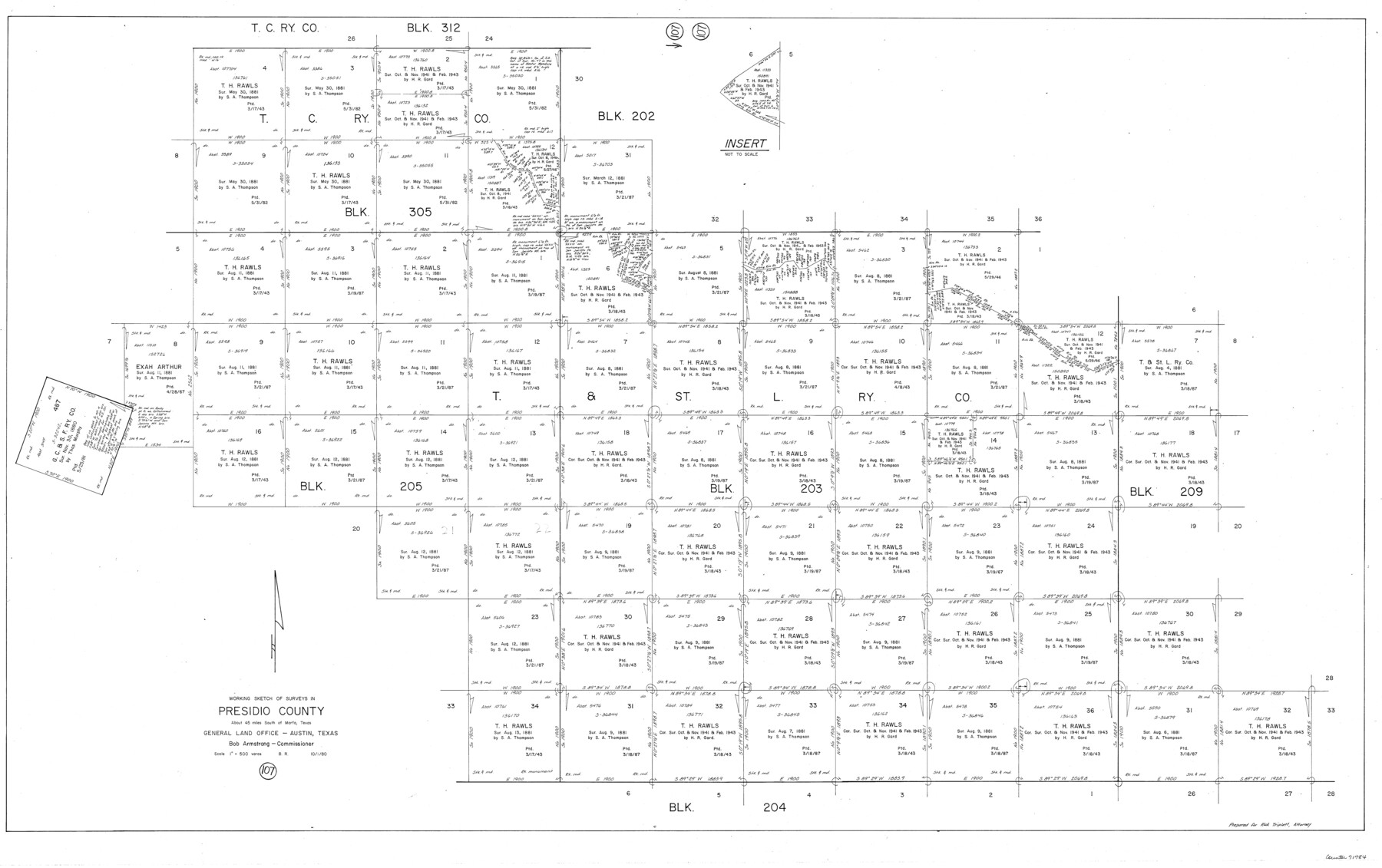
Presidio County Working Sketch 107
-
Map/Doc
71784
-
Collection
General Map Collection
-
Object Dates
10/1/1980 (Creation Date)
-
People and Organizations
Beverly Robison (Draftsman)
-
Counties
Presidio
-
Subjects
Surveying Working Sketch
-
Height x Width
36.0 x 57.3 inches
91.4 x 145.5 cm
-
Scale
1" = 500 varas
Part of: General Map Collection
Hutchinson Co.

Print $20.00
- Digital $50.00
Hutchinson Co.
1891
Size 27.5 x 21.3 inches
Map/Doc 4986
Harrison County Sketch File 15

Print $20.00
- Digital $50.00
Harrison County Sketch File 15
Size 23.2 x 23.0 inches
Map/Doc 11690
Atascosa County Working Sketch 27

Print $20.00
- Digital $50.00
Atascosa County Working Sketch 27
1963
Size 16.8 x 18.6 inches
Map/Doc 67223
Flight Mission No. DAG-23K, Frame 19, Matagorda County

Print $20.00
- Digital $50.00
Flight Mission No. DAG-23K, Frame 19, Matagorda County
1953
Size 18.5 x 22.2 inches
Map/Doc 86481
University Land Field Notes for Blocks 1, 2, 3, 4, 5, 8, 9, and 10 in Andrews County, Block 6 in Andrews, Dawson, Gaines, and Martin Counties, and Block 7 in Andrews and Martin Counties

University Land Field Notes for Blocks 1, 2, 3, 4, 5, 8, 9, and 10 in Andrews County, Block 6 in Andrews, Dawson, Gaines, and Martin Counties, and Block 7 in Andrews and Martin Counties
Map/Doc 81710
Presidio County Working Sketch 122

Print $20.00
- Digital $50.00
Presidio County Working Sketch 122
1984
Size 42.6 x 45.6 inches
Map/Doc 71800
Flight Mission No. DIX-5P, Frame 138, Aransas County

Print $20.00
- Digital $50.00
Flight Mission No. DIX-5P, Frame 138, Aransas County
1956
Size 17.7 x 17.9 inches
Map/Doc 83799
Flight Mission No. CGI-3N, Frame 77, Cameron County

Print $20.00
- Digital $50.00
Flight Mission No. CGI-3N, Frame 77, Cameron County
1954
Size 18.6 x 22.2 inches
Map/Doc 84571
Flight Mission No. BQR-13K, Frame 119, Brazoria County

Print $20.00
- Digital $50.00
Flight Mission No. BQR-13K, Frame 119, Brazoria County
1952
Size 19.0 x 22.6 inches
Map/Doc 84080
Flight Mission No. BRA-16M, Frame 124, Jefferson County

Print $20.00
- Digital $50.00
Flight Mission No. BRA-16M, Frame 124, Jefferson County
1953
Size 18.7 x 22.5 inches
Map/Doc 85734
Kimble County Working Sketch 4

Print $20.00
- Digital $50.00
Kimble County Working Sketch 4
1913
Size 26.8 x 21.7 inches
Map/Doc 70072
Chambers County Sketch File 2

Print $8.00
- Digital $50.00
Chambers County Sketch File 2
Size 13.4 x 10.5 inches
Map/Doc 17518
You may also like
Bowie County Working Sketch 13

Print $20.00
- Digital $50.00
Bowie County Working Sketch 13
1959
Size 36.9 x 37.0 inches
Map/Doc 67417
Brewster County Sketch File N-14

Print $24.00
- Digital $50.00
Brewster County Sketch File N-14
1938
Size 14.4 x 8.9 inches
Map/Doc 15629
Map of Kinney County

Print $40.00
- Digital $50.00
Map of Kinney County
1889
Size 50.1 x 41.1 inches
Map/Doc 16869
Block 1 H&GN RR Co.

Print $20.00
- Digital $50.00
Block 1 H&GN RR Co.
Size 39.3 x 40.3 inches
Map/Doc 89769
Hardin County Sketch File 6

Print $4.00
- Digital $50.00
Hardin County Sketch File 6
Size 8.0 x 12.7 inches
Map/Doc 25097
Harris County Sketch File 5

Print $20.00
- Digital $50.00
Harris County Sketch File 5
1858
Size 22.0 x 15.0 inches
Map/Doc 11648
[Leagues 258, 259, 278, 287, 288, and Vicinity]
![91459, [Leagues 258, 259, 278, 287, 288, and Vicinity], Twichell Survey Records](https://historictexasmaps.com/wmedia_w700/maps/91459-1.tif.jpg)
Print $20.00
- Digital $50.00
[Leagues 258, 259, 278, 287, 288, and Vicinity]
Size 20.0 x 34.9 inches
Map/Doc 91459
Angelina County Working Sketch 41

Print $20.00
- Digital $50.00
Angelina County Working Sketch 41
1960
Size 33.9 x 21.6 inches
Map/Doc 67124
Gaines County Boundary File 2

Print $42.00
- Digital $50.00
Gaines County Boundary File 2
Size 11.5 x 52.3 inches
Map/Doc 53652
Flight Mission No. DQN-2K, Frame 38, Calhoun County

Print $20.00
- Digital $50.00
Flight Mission No. DQN-2K, Frame 38, Calhoun County
1953
Size 15.5 x 15.4 inches
Map/Doc 84243
Travis County State Real Property Sketch 14

Print $40.00
- Digital $50.00
Travis County State Real Property Sketch 14
1995
Size 18.1 x 23.9 inches
Map/Doc 61672
Chambers County Sketch File 14

Print $8.00
- Digital $50.00
Chambers County Sketch File 14
1862
Size 4.3 x 5.1 inches
Map/Doc 17560