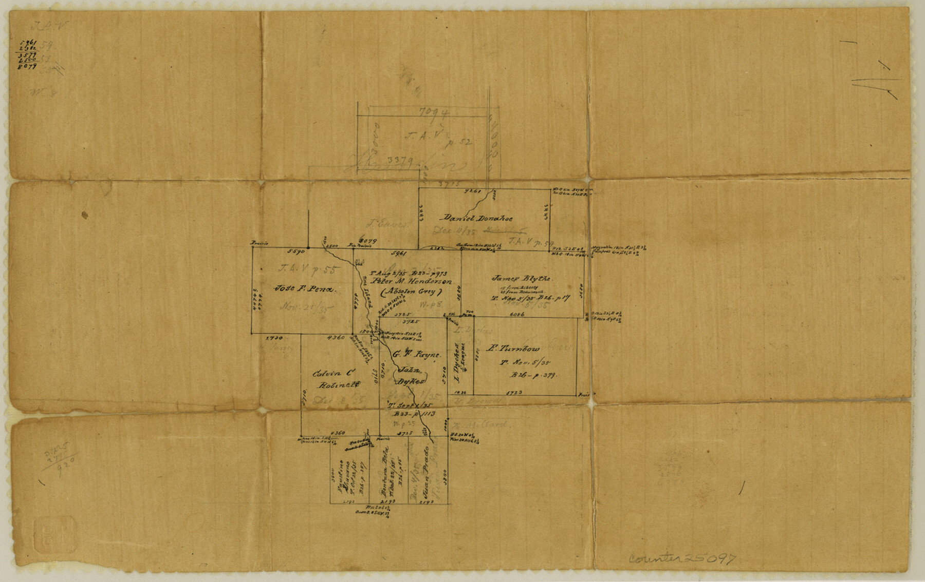
Hardin County Sketch File 6
[Sketch of surveys in southwest part of county]
-
Map/Doc
25097
-
Collection
General Map Collection
-
Counties
Hardin
-
Subjects
Surveying Sketch File
-
Height x Width
8.0 x 12.7 inches
20.3 x 32.3 cm
-
Medium
paper, manuscript
-
Features
Pine Island Bayou
Part of: General Map Collection
Harris County Working Sketch 24

Print $20.00
- Digital $50.00
Harris County Working Sketch 24
1928
Size 29.3 x 15.9 inches
Map/Doc 65916
Young County Working Sketch 22

Print $20.00
- Digital $50.00
Young County Working Sketch 22
1965
Size 26.5 x 32.3 inches
Map/Doc 62045
Leon County Rolled Sketch 21

Print $20.00
- Digital $50.00
Leon County Rolled Sketch 21
Size 33.5 x 24.3 inches
Map/Doc 75971
Map of Denton County

Print $20.00
- Digital $50.00
Map of Denton County
1897
Size 45.0 x 41.2 inches
Map/Doc 66802
Nueces County Sketch File 34

Print $6.00
- Digital $50.00
Nueces County Sketch File 34
1908
Size 11.6 x 12.9 inches
Map/Doc 32611
Surveyors report on resurvey of Capitol Leagues in three parts, also copy of judgement of the District Court, Travis County

Print $20.00
- Digital $50.00
Surveyors report on resurvey of Capitol Leagues in three parts, also copy of judgement of the District Court, Travis County
Size 12.3 x 15.8 inches
Map/Doc 62579
Current Miscellaneous File 106

Print $36.00
- Digital $50.00
Current Miscellaneous File 106
Size 8.6 x 11.3 inches
Map/Doc 74689
Flight Mission No. DQO-3K, Frame 21, Galveston County

Print $20.00
- Digital $50.00
Flight Mission No. DQO-3K, Frame 21, Galveston County
1952
Size 18.9 x 22.5 inches
Map/Doc 85062
Map Showing Location of Dallas & Greenville Railroad through Rockwall County, Texas

Print $3.00
- Digital $50.00
Map Showing Location of Dallas & Greenville Railroad through Rockwall County, Texas
Size 7.9 x 17.5 inches
Map/Doc 64485
Upshur County Rolled Sketch 2

Print $20.00
- Digital $50.00
Upshur County Rolled Sketch 2
1954
Size 26.8 x 23.4 inches
Map/Doc 8061
The Texas and Pacific Ry. Co., Station Map, Iatan, Mitchell County, Texas

Print $20.00
- Digital $50.00
The Texas and Pacific Ry. Co., Station Map, Iatan, Mitchell County, Texas
1929
Size 11.0 x 18.4 inches
Map/Doc 64667
Calhoun County NRC Article 33.136 Sketch 12

Print $24.00
Calhoun County NRC Article 33.136 Sketch 12
2023
Map/Doc 97271
You may also like
Hudspeth County Rolled Sketch 60

Print $20.00
- Digital $50.00
Hudspeth County Rolled Sketch 60
1982
Size 43.4 x 44.4 inches
Map/Doc 9225
Trinity County Working Sketch 27

Print $20.00
- Digital $50.00
Trinity County Working Sketch 27
2010
Size 26.8 x 36.8 inches
Map/Doc 90069
[Abstract Numbering Register - Donley through Karnes]
![82966, [Abstract Numbering Register - Donley through Karnes], General Map Collection](https://historictexasmaps.com/wmedia_w700/pdf_converted_jpg/qi_pdf_thumbnail_30613.jpg)
[Abstract Numbering Register - Donley through Karnes]
Map/Doc 82966
Shelby County Rolled Sketch 18

Print $20.00
- Digital $50.00
Shelby County Rolled Sketch 18
1975
Size 36.2 x 40.7 inches
Map/Doc 9926
Hunt County Sketch File 30

Print $6.00
- Digital $50.00
Hunt County Sketch File 30
1862
Size 8.1 x 7.5 inches
Map/Doc 27132
Map of the Northeast part of the Pitchfork Ranch

Print $20.00
- Digital $50.00
Map of the Northeast part of the Pitchfork Ranch
1916
Size 23.2 x 23.6 inches
Map/Doc 91046
Travis County

Print $20.00
- Digital $50.00
Travis County
1895
Size 47.8 x 46.4 inches
Map/Doc 82079
Nacogdoches County Sketch File 7

Print $6.00
- Digital $50.00
Nacogdoches County Sketch File 7
1875
Size 10.4 x 15.0 inches
Map/Doc 32250
[Sketch for Mineral Application 16700 - Pecos River Bed]
![2807, [Sketch for Mineral Application 16700 - Pecos River Bed], General Map Collection](https://historictexasmaps.com/wmedia_w700/maps/2807.tif.jpg)
Print $20.00
- Digital $50.00
[Sketch for Mineral Application 16700 - Pecos River Bed]
1927
Size 32.9 x 15.3 inches
Map/Doc 2807
Tom Green County Sketch File 77

Print $6.00
- Digital $50.00
Tom Green County Sketch File 77
Size 10.0 x 8.5 inches
Map/Doc 38253
[Sketch showing T. & N. O. Blocks 3T and 6T, Denison and Pacific RR. Co. Block O-18 and surrounding areas]
![93001, [Sketch showing T. & N. O. Blocks 3T and 6T, Denison and Pacific RR. Co. Block O-18 and surrounding areas], Twichell Survey Records](https://historictexasmaps.com/wmedia_w700/maps/93001-1.tif.jpg)
Print $20.00
- Digital $50.00
[Sketch showing T. & N. O. Blocks 3T and 6T, Denison and Pacific RR. Co. Block O-18 and surrounding areas]
Size 21.0 x 28.5 inches
Map/Doc 93001
General Highway Map. Detail of Cities and Towns in Harris County, Texas. City Map [of] Houston, Pasadena, West University Place, Bellaire, Galena Park, Jacinto City, South Houston, South Side Place, Deer Park, and vicinity, Harris County, Texas
![79504, General Highway Map. Detail of Cities and Towns in Harris County, Texas. City Map [of] Houston, Pasadena, West University Place, Bellaire, Galena Park, Jacinto City, South Houston, South Side Place, Deer Park, and vicinity, Harris County, Texas, Texas State Library and Archives](https://historictexasmaps.com/wmedia_w700/maps/79504.tif.jpg)
Print $20.00
General Highway Map. Detail of Cities and Towns in Harris County, Texas. City Map [of] Houston, Pasadena, West University Place, Bellaire, Galena Park, Jacinto City, South Houston, South Side Place, Deer Park, and vicinity, Harris County, Texas
1961
Size 18.1 x 24.8 inches
Map/Doc 79504