Shelby County Rolled Sketch 18
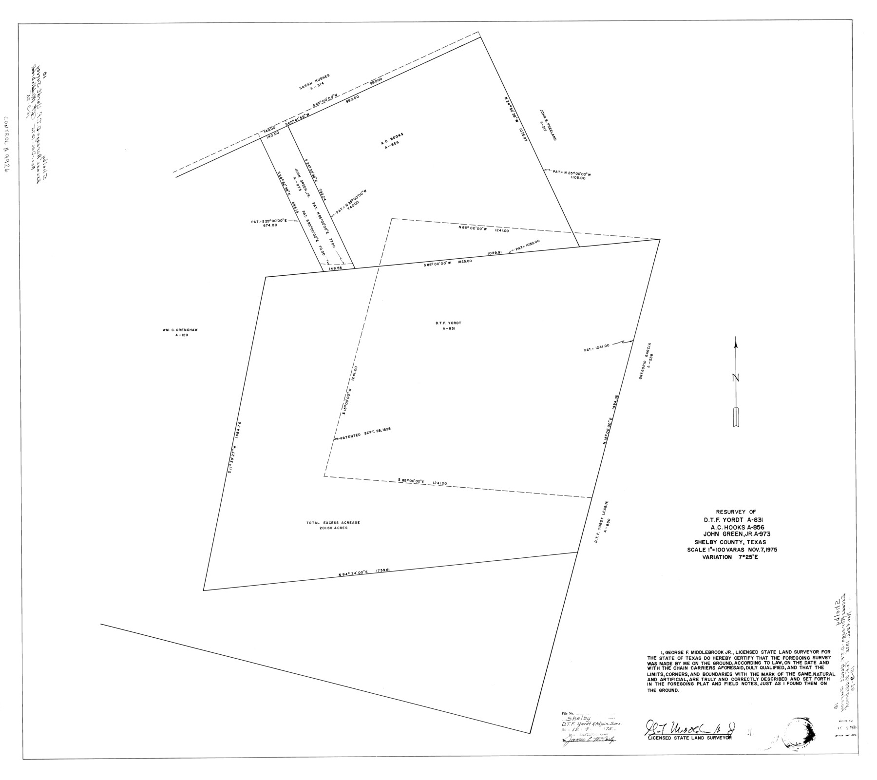
Resurvey of D.T.F. Yordt A-831, A.C. Hooks A-856, John Green, Jr. A-973, Shelby County, Texas
-
Map/Doc
9926
-
Collection
General Map Collection
-
Object Dates
1975/11/7 (Creation Date)
1975/12/9 (File Date)
-
People and Organizations
George F. Middlebrook, Jr. (Surveyor/Engineer)
-
Counties
Shelby
-
Subjects
Surveying Rolled Sketch
-
Height x Width
36.2 x 40.7 inches
91.9 x 103.4 cm
-
Medium
mylar, print
-
Scale
1" = 100 varas
Part of: General Map Collection
Hunt County Boundary File 7

Print $14.00
- Digital $50.00
Hunt County Boundary File 7
Size 14.1 x 8.7 inches
Map/Doc 55228
Refugio County Sketch File 11

Print $6.00
- Digital $50.00
Refugio County Sketch File 11
Size 8.0 x 8.2 inches
Map/Doc 35260
Mexico, Regia et Celebris Hispaniae Novae Civitas [and] Cusco, Rengi Peru in Novo Orbe Casvt
![97025, Mexico, Regia et Celebris Hispaniae Novae Civitas [and] Cusco, Rengi Peru in Novo Orbe Casvt, General Map Collection](https://historictexasmaps.com/wmedia_w700/maps/97025-1.tif.jpg)
Print $20.00
- Digital $50.00
Mexico, Regia et Celebris Hispaniae Novae Civitas [and] Cusco, Rengi Peru in Novo Orbe Casvt
1572
Size 13.8 x 20.1 inches
Map/Doc 97025
Navarro County Sketch File 17

Print $4.00
- Digital $50.00
Navarro County Sketch File 17
Size 12.8 x 8.4 inches
Map/Doc 32333
Flight Mission No. DAH-17M, Frame 65, Orange County

Print $20.00
- Digital $50.00
Flight Mission No. DAH-17M, Frame 65, Orange County
1953
Size 18.8 x 22.5 inches
Map/Doc 86899
Motley County Sketch File DD (S)

Print $22.00
- Digital $50.00
Motley County Sketch File DD (S)
Size 10.9 x 7.1 inches
Map/Doc 32159
Hutchinson County Sketch File 8

Print $8.00
- Digital $50.00
Hutchinson County Sketch File 8
1882
Size 14.2 x 8.8 inches
Map/Doc 27205
Wilbarger County Sketch File 21

Print $4.00
- Digital $50.00
Wilbarger County Sketch File 21
1889
Size 11.1 x 8.6 inches
Map/Doc 40219
Menard County Working Sketch 26

Print $20.00
- Digital $50.00
Menard County Working Sketch 26
1961
Size 28.6 x 36.1 inches
Map/Doc 70973
Travis County

Print $40.00
- Digital $50.00
Travis County
1880
Size 61.7 x 24.0 inches
Map/Doc 87934
Burnet County Rolled Sketch 8

Print $40.00
- Digital $50.00
Burnet County Rolled Sketch 8
1971
Size 36.9 x 49.9 inches
Map/Doc 8554
El Paso County Sketch File 18

Print $20.00
- Digital $50.00
El Paso County Sketch File 18
Size 19.0 x 23.8 inches
Map/Doc 11454
You may also like
Flight Mission No. DIX-10P, Frame 72, Aransas County

Print $20.00
- Digital $50.00
Flight Mission No. DIX-10P, Frame 72, Aransas County
1956
Size 18.8 x 22.4 inches
Map/Doc 83933
Lipscomb County Boundary File 14

Print $62.00
- Digital $50.00
Lipscomb County Boundary File 14
Size 13.3 x 8.8 inches
Map/Doc 56355
Your Opportunity - the Magic Valley - Money Will Grow on Trees! Learn Where How and Why!

Your Opportunity - the Magic Valley - Money Will Grow on Trees! Learn Where How and Why!
1928
Map/Doc 96740
Bowie County Rolled Sketch 6

Print $20.00
- Digital $50.00
Bowie County Rolled Sketch 6
1992
Size 11.3 x 18.1 inches
Map/Doc 5161
[PSL Block B1 and T. & P. Blocks 45 and 46, Township 1N]
![91967, [PSL Block B1 and T. & P. Blocks 45 and 46, Township 1N], Twichell Survey Records](https://historictexasmaps.com/wmedia_w700/maps/91967-1.tif.jpg)
Print $20.00
- Digital $50.00
[PSL Block B1 and T. & P. Blocks 45 and 46, Township 1N]
Size 40.8 x 10.6 inches
Map/Doc 91967
General Highway Map, Bandera County, Texas

Print $20.00
General Highway Map, Bandera County, Texas
1961
Size 18.3 x 25.0 inches
Map/Doc 79360
Yoakum County

Print $20.00
- Digital $50.00
Yoakum County
1938
Size 24.9 x 24.6 inches
Map/Doc 92446
Pecos County Sketch File 14A

Print $20.00
- Digital $50.00
Pecos County Sketch File 14A
Size 33.7 x 23.0 inches
Map/Doc 12158
Flight Mission No. DAG-22K, Frame 83, Matagorda County

Print $20.00
- Digital $50.00
Flight Mission No. DAG-22K, Frame 83, Matagorda County
1953
Size 18.5 x 18.7 inches
Map/Doc 86467
Reagan County Working Sketch 46a

Print $20.00
- Digital $50.00
Reagan County Working Sketch 46a
1970
Size 34.5 x 30.4 inches
Map/Doc 71888
Glasscock County Working Sketch 8

Print $40.00
- Digital $50.00
Glasscock County Working Sketch 8
1955
Size 43.5 x 120.3 inches
Map/Doc 63181
Tarrant County Sketch File 28

Print $4.00
- Digital $50.00
Tarrant County Sketch File 28
1876
Size 8.0 x 8.0 inches
Map/Doc 37743