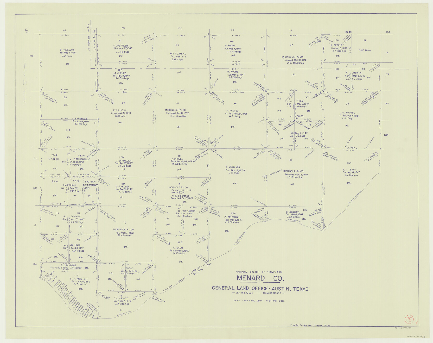
Menard County Working Sketch 26
-
Map/Doc
70973
-
Collection
General Map Collection
-
Object Dates
8/4/1961 (Creation Date)
-
Counties
Menard McCulloch
-
Subjects
Surveying Working Sketch
-
Height x Width
28.6 x 36.1 inches
72.6 x 91.7 cm
-
Scale
1" = 400 varas
Part of: General Map Collection
Starr County Boundary File 1a

Print $20.00
- Digital $50.00
Starr County Boundary File 1a
Size 22.4 x 41.0 inches
Map/Doc 58813
Jack County Working Sketch 7

Print $20.00
- Digital $50.00
Jack County Working Sketch 7
1953
Size 37.2 x 31.9 inches
Map/Doc 66433
Brazos County Working Sketch 9

Print $20.00
- Digital $50.00
Brazos County Working Sketch 9
1982
Size 36.2 x 48.8 inches
Map/Doc 67484
Denton County Sketch File 17

Print $4.00
- Digital $50.00
Denton County Sketch File 17
1857
Size 12.7 x 8.4 inches
Map/Doc 20729
Map of Austin County

Print $20.00
- Digital $50.00
Map of Austin County
1860
Size 27.9 x 26.7 inches
Map/Doc 3252
Flight Mission No. CRK-7P, Frame 134, Refugio County

Print $20.00
- Digital $50.00
Flight Mission No. CRK-7P, Frame 134, Refugio County
1956
Size 18.4 x 22.1 inches
Map/Doc 86957
Webb County Boundary File 8

Print $113.00
- Digital $50.00
Webb County Boundary File 8
Size 14.3 x 8.8 inches
Map/Doc 59822
Lamb County Sketch File 2

Print $40.00
- Digital $50.00
Lamb County Sketch File 2
1888
Size 17.1 x 14.4 inches
Map/Doc 29342
Loving County

Print $20.00
- Digital $50.00
Loving County
1932
Size 32.4 x 44.0 inches
Map/Doc 77358
Portion of States Submerged Area in Matagorda Bay

Print $20.00
- Digital $50.00
Portion of States Submerged Area in Matagorda Bay
1923
Size 12.7 x 13.5 inches
Map/Doc 2956
[Cotton Belt, St. Louis Southwestern Railway of Texas, Alignment through Smith County]
![64376, [Cotton Belt, St. Louis Southwestern Railway of Texas, Alignment through Smith County], General Map Collection](https://historictexasmaps.com/wmedia_w700/maps/64376-1.tif.jpg)
Print $20.00
- Digital $50.00
[Cotton Belt, St. Louis Southwestern Railway of Texas, Alignment through Smith County]
1903
Size 22.0 x 29.3 inches
Map/Doc 64376
Glasscock County Sketch File 11

Print $6.00
- Digital $50.00
Glasscock County Sketch File 11
1933
Size 15.7 x 11.4 inches
Map/Doc 24174
You may also like
Anderson County

Print $40.00
- Digital $50.00
Anderson County
1942
Size 52.9 x 47.9 inches
Map/Doc 66702
Bosque County Sketch File 6

Print $4.00
- Digital $50.00
Bosque County Sketch File 6
1851
Size 12.1 x 7.6 inches
Map/Doc 14748
Freestone County

Print $20.00
- Digital $50.00
Freestone County
1918
Size 46.8 x 39.8 inches
Map/Doc 4702
Real County Working Sketch 49

Print $20.00
- Digital $50.00
Real County Working Sketch 49
1957
Size 25.9 x 25.7 inches
Map/Doc 71941
Jones County Sketch File 10a

Print $40.00
- Digital $50.00
Jones County Sketch File 10a
1875
Size 40.0 x 50.6 inches
Map/Doc 10509
Loving County Working Sketch 11

Print $40.00
- Digital $50.00
Loving County Working Sketch 11
1957
Size 21.6 x 50.9 inches
Map/Doc 70644
Middle Sulphur and South Sulphur Rivers, Horton Sheet

Print $20.00
- Digital $50.00
Middle Sulphur and South Sulphur Rivers, Horton Sheet
1925
Size 42.2 x 40.3 inches
Map/Doc 65171
Flight Mission No. BRE-3P, Frame 96, Nueces County

Print $20.00
- Digital $50.00
Flight Mission No. BRE-3P, Frame 96, Nueces County
1956
Size 18.3 x 22.2 inches
Map/Doc 86827
Edward K. Warren Subdivision No. 1 Block-W Situated in Bailey, Lamb, Parmer, and Castro Counties, Texas

Print $20.00
- Digital $50.00
Edward K. Warren Subdivision No. 1 Block-W Situated in Bailey, Lamb, Parmer, and Castro Counties, Texas
1913
Size 17.6 x 14.5 inches
Map/Doc 92163
San Patricio County Rolled Sketch 49

Print $20.00
- Digital $50.00
San Patricio County Rolled Sketch 49
1979
Size 19.7 x 17.7 inches
Map/Doc 7734

Crockett County Working Sketch 45

Print $20.00
- Digital $50.00
Crockett County Working Sketch 45
1933
Size 33.7 x 26.8 inches
Map/Doc 68378