Calhoun County NRC Article 33.136 Sketch 12
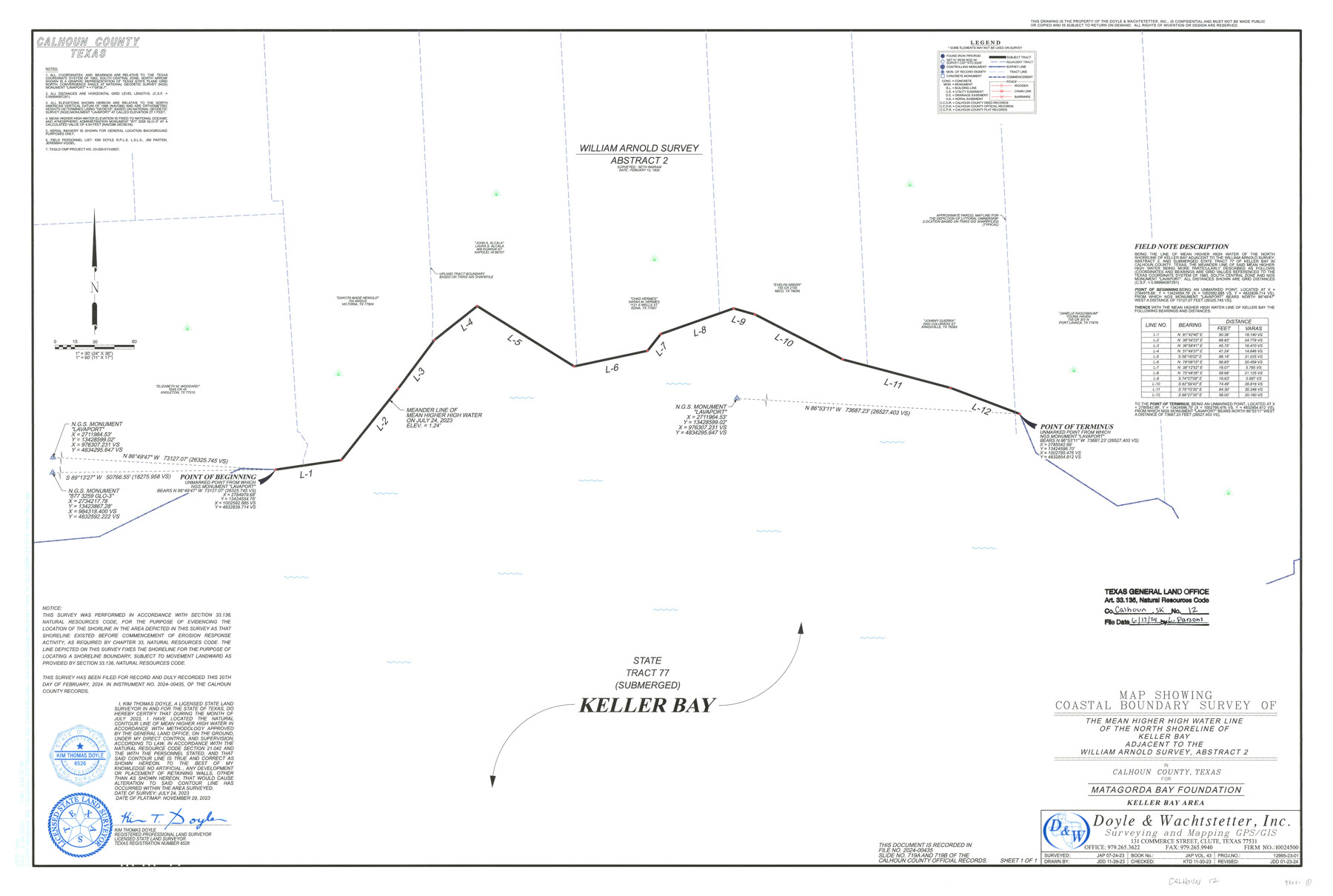
Map showing Coastal Boundary Survey of the mean higher high water line of the north shoreline of Keller Bay adjacent to the William Arnold Survey, Abstract 2
-
Map/Doc
97271
-
Collection
General Map Collection
-
Object Dates
11/29/2023 (Creation Date)
6/17/2024 (File Date)
7/24/2023 (Survey Date)
1/23/2024 (Revision Date)
-
People and Organizations
Kim Thomas Doyle (Surveyor/Engineer)
-
Counties
Calhoun
-
Subjects
Surveying CBS
-
Scale
1" = 30 feet
-
Comments
Project: Matagorda Bay Foundation - Keller Bay Area, Calhoun County
Project No.: TGLO CMP No. 23-020-013-D607
Part of: General Map Collection
Duval County Working Sketch 26

Print $20.00
- Digital $50.00
Duval County Working Sketch 26
1947
Size 34.8 x 36.9 inches
Map/Doc 68750
Comanche County Milam Land District

Print $20.00
- Digital $50.00
Comanche County Milam Land District
1876
Size 22.1 x 23.0 inches
Map/Doc 3433
Flight Mission No. BRA-16M, Frame 115, Jefferson County

Print $20.00
- Digital $50.00
Flight Mission No. BRA-16M, Frame 115, Jefferson County
1953
Size 18.5 x 22.2 inches
Map/Doc 85725
Presidio County Rolled Sketch 28

Print $20.00
- Digital $50.00
Presidio County Rolled Sketch 28
1886
Size 25.0 x 45.8 inches
Map/Doc 76140
[Surveys along the Red River, Bois d'Arc Creek, Duck Creek, and Choctaw Bayou made under G.W. Smyth, Commissioner]
![74, [Surveys along the Red River, Bois d'Arc Creek, Duck Creek, and Choctaw Bayou made under G.W. Smyth, Commissioner], General Map Collection](https://historictexasmaps.com/wmedia_w700/maps/74.tif.jpg)
Print $20.00
- Digital $50.00
[Surveys along the Red River, Bois d'Arc Creek, Duck Creek, and Choctaw Bayou made under G.W. Smyth, Commissioner]
1834
Size 19.7 x 16.0 inches
Map/Doc 74
Childress Co.

Print $20.00
- Digital $50.00
Childress Co.
1978
Size 46.2 x 35.0 inches
Map/Doc 73105
Matagorda County Working Sketch 6

Print $20.00
- Digital $50.00
Matagorda County Working Sketch 6
1950
Size 24.2 x 41.5 inches
Map/Doc 70864
Zavala County Sketch File 9

Print $20.00
- Digital $50.00
Zavala County Sketch File 9
1884
Size 29.1 x 15.9 inches
Map/Doc 12727
Crockett County Rolled Sketch 5

Print $40.00
- Digital $50.00
Crockett County Rolled Sketch 5
Size 25.0 x 63.0 inches
Map/Doc 8689
Webb County Sketch File 13-1

Print $6.00
- Digital $50.00
Webb County Sketch File 13-1
Size 8.5 x 7.8 inches
Map/Doc 39804
Flight Mission No. CRC-2R, Frame 188, Chambers County

Print $20.00
- Digital $50.00
Flight Mission No. CRC-2R, Frame 188, Chambers County
1956
Size 18.5 x 22.3 inches
Map/Doc 84766
Shelby County Sketch File 23

Print $5.00
- Digital $50.00
Shelby County Sketch File 23
Size 16.2 x 7.3 inches
Map/Doc 36645
You may also like
Map of Tom Green County

Print $20.00
- Digital $50.00
Map of Tom Green County
1892
Size 44.1 x 47.5 inches
Map/Doc 78389
[Surveys in the Bexar District along the Balcones, Cibolo and Leon Creeks]
![63, [Surveys in the Bexar District along the Balcones, Cibolo and Leon Creeks], General Map Collection](https://historictexasmaps.com/wmedia_w700/maps/63.tif.jpg)
Print $3.00
- Digital $50.00
[Surveys in the Bexar District along the Balcones, Cibolo and Leon Creeks]
1842
Size 10.6 x 12.4 inches
Map/Doc 63
Edwards County Sketch File 46

Print $26.00
- Digital $50.00
Edwards County Sketch File 46
1954
Size 11.3 x 8.7 inches
Map/Doc 21792
Tarrant County Working Sketch 12

Print $20.00
- Digital $50.00
Tarrant County Working Sketch 12
1986
Size 30.8 x 23.4 inches
Map/Doc 62429
Culberson County Rolled Sketch 39

Print $20.00
- Digital $50.00
Culberson County Rolled Sketch 39
Size 25.6 x 19.3 inches
Map/Doc 5783
[Sections 1 & 2, Block S]
![92859, [Sections 1 & 2, Block S], Twichell Survey Records](https://historictexasmaps.com/wmedia_w700/maps/92859-1.tif.jpg)
Print $20.00
- Digital $50.00
[Sections 1 & 2, Block S]
Size 27.8 x 15.7 inches
Map/Doc 92859
[Surveys in the Bexar District along the Medina River]
![128, [Surveys in the Bexar District along the Medina River], General Map Collection](https://historictexasmaps.com/wmedia_w700/maps/128.tif.jpg)
Print $20.00
- Digital $50.00
[Surveys in the Bexar District along the Medina River]
1841
Size 23.0 x 16.8 inches
Map/Doc 128
Connected Map of Austin's Colony

Print $40.00
- Digital $50.00
Connected Map of Austin's Colony
1837
Size 93.2 x 43.1 inches
Map/Doc 93376

Map of the State of Texas [West Part]
![81921, Map of the State of Texas [West Part], General Map Collection](https://historictexasmaps.com/wmedia_w700/maps/81921.tif.jpg)
Print $40.00
- Digital $50.00
Map of the State of Texas [West Part]
1938
Size 68.7 x 38.2 inches
Map/Doc 81921
Gillespie County Working Sketch 14

Print $20.00
- Digital $50.00
Gillespie County Working Sketch 14
2011
Size 36.6 x 36.6 inches
Map/Doc 90096
Cass County Working Sketch 7

Print $20.00
- Digital $50.00
Cass County Working Sketch 7
1937
Size 21.9 x 28.9 inches
Map/Doc 67910