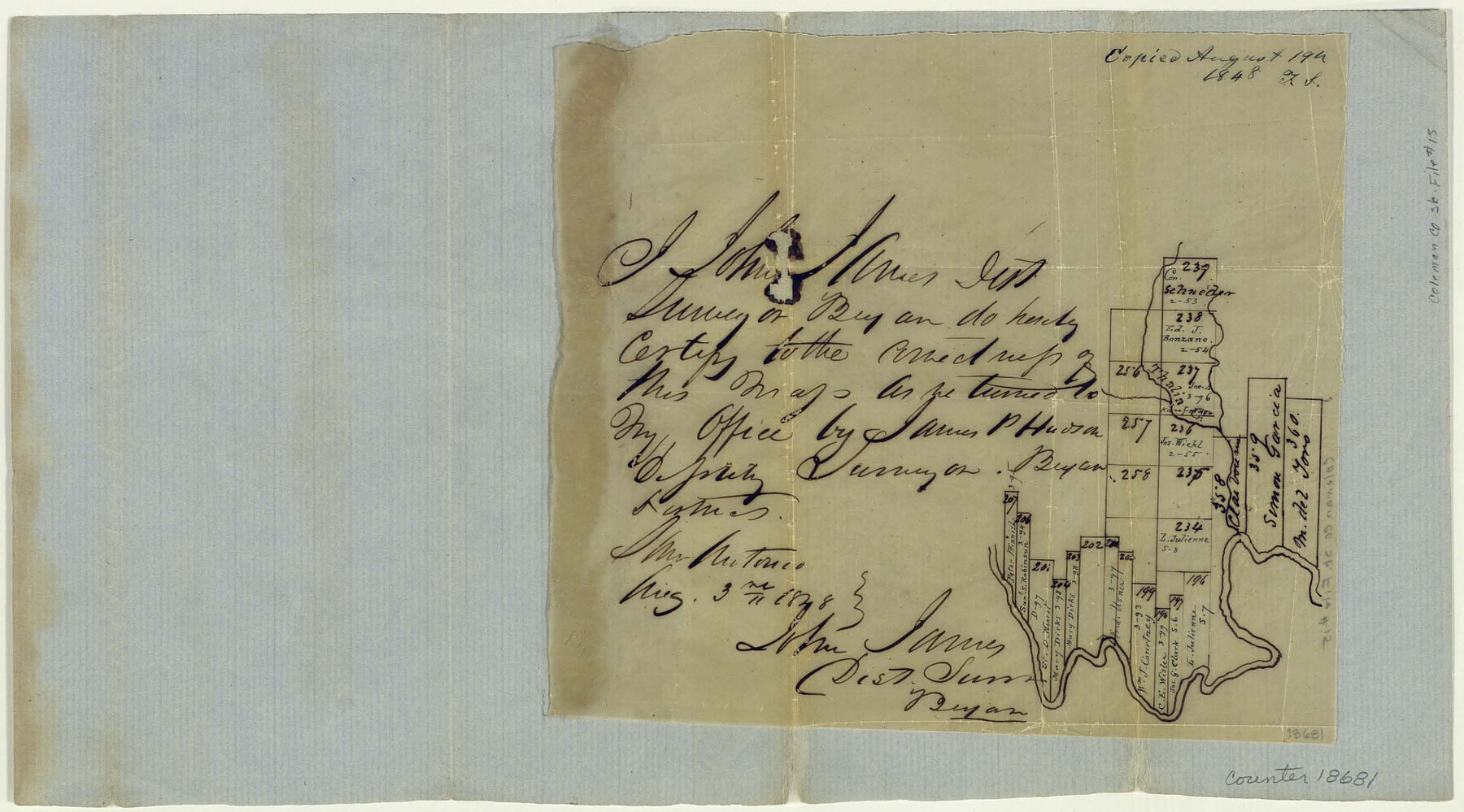
Coleman County Sketch File 15
[Sketch of surveys on Thalia Creek and north bank of Colorado River]
-
Map/Doc
18681
-
Collection
General Map Collection
-
Object Dates
1848/8/14 (File Date)
1848/8/3 (Creation Date)
-
People and Organizations
John James (Surveyor/Engineer)
-
Counties
Coleman
-
Subjects
Surveying Sketch File
-
Height x Width
7.3 x 13.0 inches
18.5 x 33.0 cm
-
Medium
paper, manuscript
-
Features
Thalia Creek
[Colorado River]
Part of: General Map Collection
Flight Mission No. BQY-15M, Frame 3, Harris County

Print $20.00
- Digital $50.00
Flight Mission No. BQY-15M, Frame 3, Harris County
1953
Size 18.7 x 22.5 inches
Map/Doc 85301
Newton County Sketch File 46

Print $18.00
- Digital $50.00
Newton County Sketch File 46
1962
Size 11.2 x 8.6 inches
Map/Doc 32451
Mills County Working Sketch 27

Print $20.00
- Digital $50.00
Mills County Working Sketch 27
2000
Size 37.3 x 47.3 inches
Map/Doc 71057
Llano County Working Sketch 6

Print $20.00
- Digital $50.00
Llano County Working Sketch 6
1961
Size 15.8 x 20.8 inches
Map/Doc 70624
Concho County Rolled Sketch 13

Print $20.00
- Digital $50.00
Concho County Rolled Sketch 13
1958
Size 23.7 x 20.3 inches
Map/Doc 78461
Val Verde County Sketch File Z10

Print $20.00
- Digital $50.00
Val Verde County Sketch File Z10
1895
Size 24.3 x 37.6 inches
Map/Doc 12555
Edwards County Rolled Sketch 18

Print $20.00
- Digital $50.00
Edwards County Rolled Sketch 18
1947
Size 21.8 x 21.2 inches
Map/Doc 5807
Aransas County Sketch File 28

Print $16.00
- Digital $50.00
Aransas County Sketch File 28
1973
Size 11.3 x 8.8 inches
Map/Doc 13226
San Jacinto County Rolled Sketch 11

Print $20.00
- Digital $50.00
San Jacinto County Rolled Sketch 11
Size 22.7 x 33.6 inches
Map/Doc 7560
[Sketch for Mineral Application 24072, San Jacinto River]
![65596, [Sketch for Mineral Application 24072, San Jacinto River], General Map Collection](https://historictexasmaps.com/wmedia_w700/maps/65596.tif.jpg)
Print $20.00
- Digital $50.00
[Sketch for Mineral Application 24072, San Jacinto River]
1929
Size 24.5 x 18.5 inches
Map/Doc 65596
Martin County Rolled Sketch 11

Print $20.00
- Digital $50.00
Martin County Rolled Sketch 11
Size 19.3 x 25.0 inches
Map/Doc 90051
Johnson County Working Sketch 12

Print $20.00
- Digital $50.00
Johnson County Working Sketch 12
1959
Size 22.9 x 22.6 inches
Map/Doc 66625
You may also like
Right of Way and Track Map, International & Gt. Northern Ry. Operated by the International & Gt. Northern Ry. Co., Gulf Division

Print $40.00
- Digital $50.00
Right of Way and Track Map, International & Gt. Northern Ry. Operated by the International & Gt. Northern Ry. Co., Gulf Division
1917
Size 24.9 x 56.6 inches
Map/Doc 64250
Map of Marion County

Print $20.00
- Digital $50.00
Map of Marion County
1901
Size 29.6 x 44.3 inches
Map/Doc 4783
Van Zandt County Sketch File 11

Print $4.00
- Digital $50.00
Van Zandt County Sketch File 11
1858
Size 10.2 x 8.1 inches
Map/Doc 39397
Val Verde County Working Sketch 63

Print $20.00
- Digital $50.00
Val Verde County Working Sketch 63
1959
Size 23.2 x 32.1 inches
Map/Doc 72198
Culberson County Working Sketch 86

Print $40.00
- Digital $50.00
Culberson County Working Sketch 86
1981
Size 37.3 x 53.3 inches
Map/Doc 68540
Flight Mission No. CRC-5R, Frame 33, Chambers County

Print $20.00
- Digital $50.00
Flight Mission No. CRC-5R, Frame 33, Chambers County
1956
Size 18.6 x 22.5 inches
Map/Doc 84952
[Resurvey of Block 1 - W. H. Godair]
![92898, [Resurvey of Block 1 - W. H. Godair], Twichell Survey Records](https://historictexasmaps.com/wmedia_w700/maps/92898-1.tif.jpg)
Print $20.00
- Digital $50.00
[Resurvey of Block 1 - W. H. Godair]
1923
Size 22.4 x 9.5 inches
Map/Doc 92898
El Paso County Sketch File 40

Print $20.00
- Digital $50.00
El Paso County Sketch File 40
1988
Size 24.8 x 35.9 inches
Map/Doc 11461
La Salle County Sketch File 6

Print $7.00
- Digital $50.00
La Salle County Sketch File 6
1875
Size 10.0 x 8.0 inches
Map/Doc 29453
Parker County Sketch File 42

Print $114.00
- Digital $50.00
Parker County Sketch File 42
1877
Size 14.4 x 12.0 inches
Map/Doc 33589
Kaufman County Sketch File 20

Print $20.00
- Digital $50.00
Kaufman County Sketch File 20
1950
Size 23.2 x 34.8 inches
Map/Doc 11908
Flight Mission No. BQY-4M, Frame 32, Harris County

Print $20.00
- Digital $50.00
Flight Mission No. BQY-4M, Frame 32, Harris County
1953
Size 18.6 x 22.6 inches
Map/Doc 85247