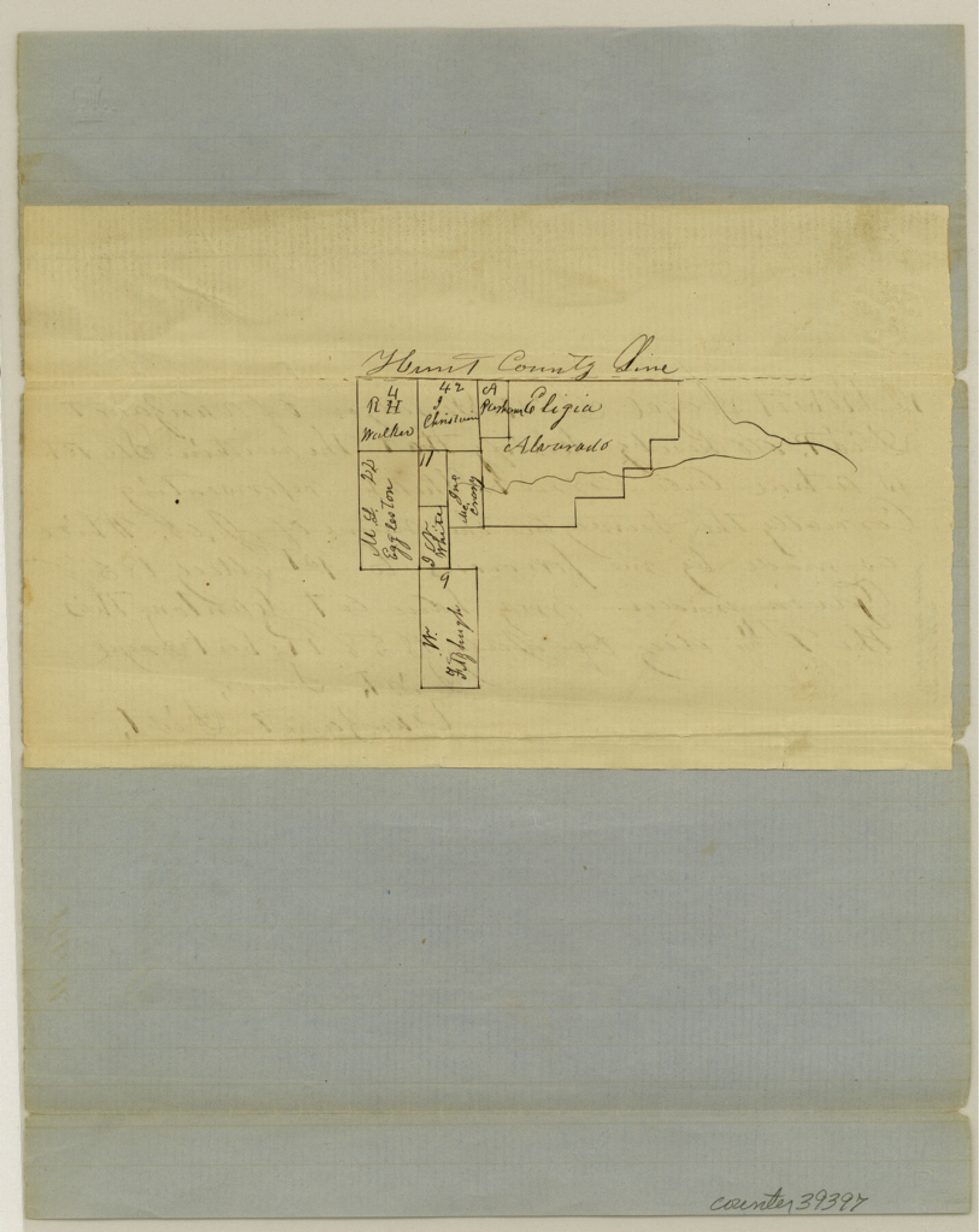
Van Zandt County Sketch File 11
[Sketch of surveys in the northwest corner of the county]
-
Map/Doc
39397
-
Collection
General Map Collection
-
Object Dates
7/9/1858 (Creation Date)
7/23/1858 (File Date)
-
People and Organizations
Robert Doyal (Surveyor/Engineer)
-
Counties
Van Zandt
-
Subjects
Surveying Sketch File
-
Height x Width
10.2 x 8.1 inches
25.9 x 20.6 cm
-
Medium
paper, manuscript
Part of: General Map Collection

Frio County Rolled Sketch 24

Print $20.00
- Digital $50.00
Frio County Rolled Sketch 24
1964
Size 22.3 x 21.1 inches
Map/Doc 5924
Hall County Working Sketch 3

Print $20.00
- Digital $50.00
Hall County Working Sketch 3
1916
Size 15.6 x 17.1 inches
Map/Doc 63331
Shackelford County Boundary File 7b

Print $90.00
- Digital $50.00
Shackelford County Boundary File 7b
Size 7.9 x 10.4 inches
Map/Doc 58692
Plan of Driving Park Addition composed of Out-lots 37, 38, 39, 49, 50, 60, & 61, Division "O" in the City of Austin

Print $20.00
- Digital $50.00
Plan of Driving Park Addition composed of Out-lots 37, 38, 39, 49, 50, 60, & 61, Division "O" in the City of Austin
1910
Size 18.4 x 15.9 inches
Map/Doc 2024
Val Verde County Working Sketch 121

Print $40.00
- Digital $50.00
Val Verde County Working Sketch 121
2005
Size 34.0 x 54.2 inches
Map/Doc 83590
San Patricio County Sketch File 12

Print $4.00
San Patricio County Sketch File 12
1859
Size 6.6 x 9.9 inches
Map/Doc 36047
Houston County Sketch File 39

Print $6.00
- Digital $50.00
Houston County Sketch File 39
1845
Size 17.0 x 10.9 inches
Map/Doc 26824
Starr County Rolled Sketch 21

Print $20.00
- Digital $50.00
Starr County Rolled Sketch 21
1921
Size 24.2 x 14.0 inches
Map/Doc 7805
Houston & Texas Central

Print $40.00
- Digital $50.00
Houston & Texas Central
Size 24.1 x 56.4 inches
Map/Doc 64797
Uvalde County Sketch File 4

Print $22.00
- Digital $50.00
Uvalde County Sketch File 4
1879
Size 12.8 x 8.3 inches
Map/Doc 38951
Flight Mission No. CRC-6R, Frame 41, Chambers County

Print $20.00
- Digital $50.00
Flight Mission No. CRC-6R, Frame 41, Chambers County
1956
Size 18.4 x 22.3 inches
Map/Doc 84974
You may also like
Coke County Working Sketch 6

Print $20.00
- Digital $50.00
Coke County Working Sketch 6
1914
Size 19.1 x 15.7 inches
Map/Doc 68043
Collin County Sketch File 5

Print $4.00
- Digital $50.00
Collin County Sketch File 5
1852
Size 9.7 x 8.5 inches
Map/Doc 18864
United States - Gulf Coast - Galveston to Rio Grande

Print $20.00
- Digital $50.00
United States - Gulf Coast - Galveston to Rio Grande
1941
Size 26.6 x 18.5 inches
Map/Doc 72752
El Paso County

Print $40.00
- Digital $50.00
El Paso County
1881
Size 52.0 x 36.8 inches
Map/Doc 89059
Flight Mission No. DQN-1K, Frame 41, Calhoun County

Print $20.00
- Digital $50.00
Flight Mission No. DQN-1K, Frame 41, Calhoun County
1953
Size 18.5 x 22.2 inches
Map/Doc 84141
Swisher Co. Texas

Print $20.00
- Digital $50.00
Swisher Co. Texas
1936
Size 36.8 x 38.0 inches
Map/Doc 89876
Map of that part of Comal County in Bexar District

Print $20.00
- Digital $50.00
Map of that part of Comal County in Bexar District
Size 16.3 x 22.1 inches
Map/Doc 3431
Upton County Working Sketch 50

Print $20.00
- Digital $50.00
Upton County Working Sketch 50
1980
Size 19.5 x 21.4 inches
Map/Doc 69547
Crane County Boundary File 1b

Print $80.00
- Digital $50.00
Crane County Boundary File 1b
Size 85.1 x 17.9 inches
Map/Doc 51969
[Leagues 391, 391 1/2 and part of Block K7]
![90534, [Leagues 391, 391 1/2 and part of Block K7], Twichell Survey Records](https://historictexasmaps.com/wmedia_w700/maps/90534-1.tif.jpg)
Print $2.00
- Digital $50.00
[Leagues 391, 391 1/2 and part of Block K7]
1902
Size 4.7 x 6.3 inches
Map/Doc 90534
Kerr County Sketch File 4

Print $10.00
- Digital $50.00
Kerr County Sketch File 4
1873
Size 8.1 x 7.7 inches
Map/Doc 28860
Flight Mission No. BRA-16M, Frame 181, Jefferson County

Print $20.00
- Digital $50.00
Flight Mission No. BRA-16M, Frame 181, Jefferson County
1953
Size 18.6 x 22.2 inches
Map/Doc 85779