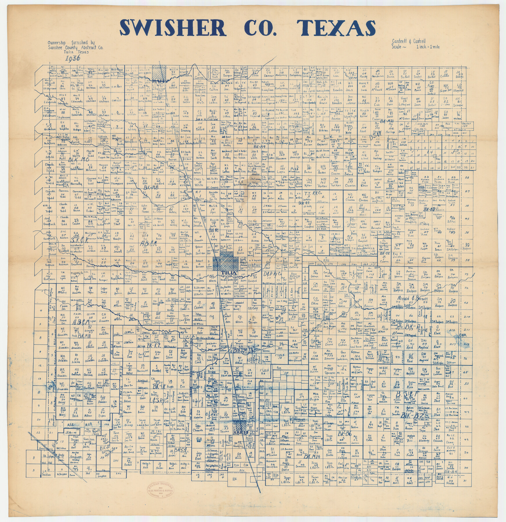
Swisher Co. Texas
-
Map/Doc
89876
-
Collection
Twichell Survey Records
-
Object Dates
1936 (Creation Date)
-
People and Organizations
Swisher County Abstract Co. (Compiler)
Cantrell & Cantrell (Draftsman)
-
Counties
Swisher
-
Subjects
County
-
Height x Width
36.8 x 38.0 inches
93.5 x 96.5 cm
Part of: Twichell Survey Records
[Jose Ostane survey]
![89983, [Jose Ostane survey], Twichell Survey Records](https://historictexasmaps.com/wmedia_w700/maps/89983-1.tif.jpg)
Print $3.00
- Digital $50.00
[Jose Ostane survey]
Size 14.6 x 9.3 inches
Map/Doc 89983
[Sketch showing Blocks B8, B15, 43, 44, 45]
![90925, [Sketch showing Blocks B8, B15, 43, 44, 45], Twichell Survey Records](https://historictexasmaps.com/wmedia_w700/maps/90925-1.tif.jpg)
Print $20.00
- Digital $50.00
[Sketch showing Blocks B8, B15, 43, 44, 45]
Size 46.7 x 22.7 inches
Map/Doc 90925
[Charles Welch, J. D. Brown, and surrounding surveys]
![91010, [Charles Welch, J. D. Brown, and surrounding surveys], Twichell Survey Records](https://historictexasmaps.com/wmedia_w700/maps/91010-1.tif.jpg)
Print $20.00
- Digital $50.00
[Charles Welch, J. D. Brown, and surrounding surveys]
Size 37.4 x 24.0 inches
Map/Doc 91010
L. Wright's Subdivision of the Southwest Corner of Survey Number 6, D4]
![90785, L. Wright's Subdivision of the Southwest Corner of Survey Number 6, D4], Twichell Survey Records](https://historictexasmaps.com/wmedia_w700/maps/90785-1.tif.jpg)
Print $20.00
- Digital $50.00
L. Wright's Subdivision of the Southwest Corner of Survey Number 6, D4]
1906
Size 14.1 x 18.5 inches
Map/Doc 90785
[Lubbock, Crosby County Line]
![91323, [Lubbock, Crosby County Line], Twichell Survey Records](https://historictexasmaps.com/wmedia_w700/maps/91323-1.tif.jpg)
Print $2.00
- Digital $50.00
[Lubbock, Crosby County Line]
Size 9.2 x 14.7 inches
Map/Doc 91323
Map of South Boundary Line of Hartley County

Print $20.00
- Digital $50.00
Map of South Boundary Line of Hartley County
Size 26.3 x 8.2 inches
Map/Doc 90685
[Garza, Blanco, Uvalde and Crosby County School Land]
![90252, [Garza, Blanco, Uvalde and Crosby County School Land], Twichell Survey Records](https://historictexasmaps.com/wmedia_w700/maps/90252-1.tif.jpg)
Print $20.00
- Digital $50.00
[Garza, Blanco, Uvalde and Crosby County School Land]
1913
Size 12.4 x 12.2 inches
Map/Doc 90252
N. F. Cleavinger

Print $3.00
- Digital $50.00
N. F. Cleavinger
Size 16.5 x 10.6 inches
Map/Doc 92406

Val Verde County, Texas, E. L. & R. R. Ry. Block D7 showing beginning point and direction of certain surveys

Print $20.00
- Digital $50.00
Val Verde County, Texas, E. L. & R. R. Ry. Block D7 showing beginning point and direction of certain surveys
1937
Size 22.1 x 17.0 inches
Map/Doc 91950
[Preliminary Drawing of School Leagues]
![89932, [Preliminary Drawing of School Leagues], Twichell Survey Records](https://historictexasmaps.com/wmedia_w700/maps/89932-1.tif.jpg)
Print $40.00
- Digital $50.00
[Preliminary Drawing of School Leagues]
Size 38.3 x 66.8 inches
Map/Doc 89932
[Capitol Leagues 217- 235, 238, and 239]
![90706, [Capitol Leagues 217- 235, 238, and 239], Twichell Survey Records](https://historictexasmaps.com/wmedia_w700/maps/90706-1.tif.jpg)
Print $20.00
- Digital $50.00
[Capitol Leagues 217- 235, 238, and 239]
Size 26.3 x 26.9 inches
Map/Doc 90706
You may also like
Flight Mission No. DQN-1K, Frame 137, Calhoun County

Print $20.00
- Digital $50.00
Flight Mission No. DQN-1K, Frame 137, Calhoun County
1953
Size 18.5 x 22.2 inches
Map/Doc 84200
Flight Mission No. DAH-9M, Frame 158, Orange County

Print $20.00
- Digital $50.00
Flight Mission No. DAH-9M, Frame 158, Orange County
1953
Size 18.4 x 22.3 inches
Map/Doc 86857

Sutton County Working Sketch 47

Print $20.00
- Digital $50.00
Sutton County Working Sketch 47
1954
Size 34.3 x 21.3 inches
Map/Doc 62390
Andrews County Rolled Sketch 44

Print $40.00
- Digital $50.00
Andrews County Rolled Sketch 44
1990
Size 37.0 x 64.8 inches
Map/Doc 94990
Pecos County Sketch File 78

Print $6.00
- Digital $50.00
Pecos County Sketch File 78
1943
Size 11.1 x 8.8 inches
Map/Doc 33911
Reeves County Rolled Sketch 32

Print $634.00
- Digital $50.00
Reeves County Rolled Sketch 32
1960
Size 10.2 x 15.4 inches
Map/Doc 48849
Throckmorton County

Print $20.00
- Digital $50.00
Throckmorton County
1885
Size 24.9 x 18.7 inches
Map/Doc 4080
Highland Lakes 1981 in the scenic Hill Country of Central Texas

Digital $50.00
Highland Lakes 1981 in the scenic Hill Country of Central Texas
1981
Size 11.3 x 16.8 inches
Map/Doc 94174
Harrison County Rolled Sketch 6

Print $20.00
- Digital $50.00
Harrison County Rolled Sketch 6
1952
Size 23.8 x 24.6 inches
Map/Doc 6151
Index for Texas Railroad ROW & track maps available on microfilm at THD & Archives and Records

Print $2.00
- Digital $50.00
Index for Texas Railroad ROW & track maps available on microfilm at THD & Archives and Records
1977
Size 11.3 x 8.8 inches
Map/Doc 60760
Flight Mission No. BRA-16M, Frame 56, Jefferson County

Print $20.00
- Digital $50.00
Flight Mission No. BRA-16M, Frame 56, Jefferson County
1953
Size 18.6 x 22.5 inches
Map/Doc 85673