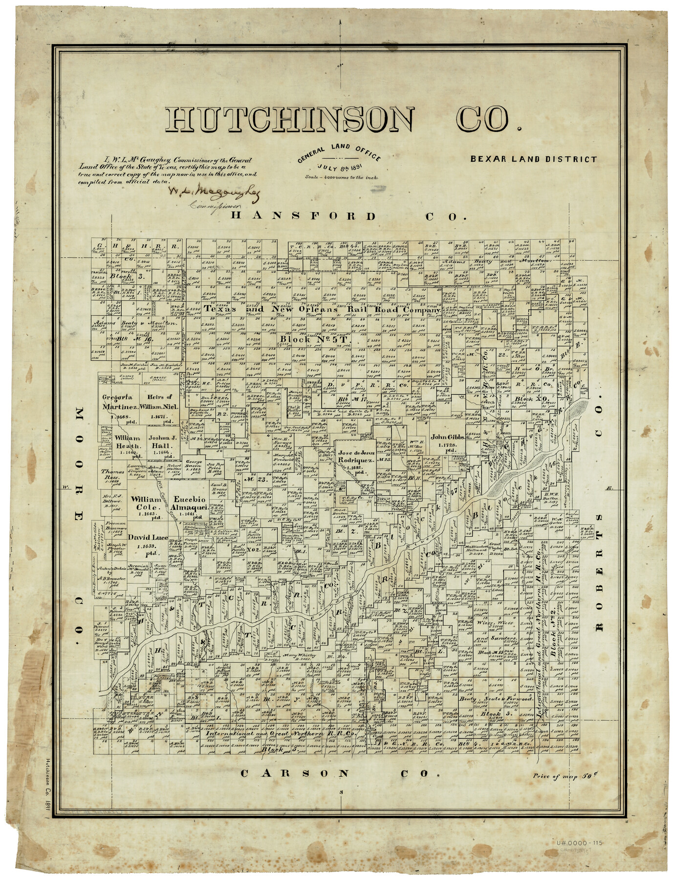
Hutchinson Co.
-
Map/Doc
4986
-
Collection
General Map Collection
-
Object Dates
7/8/1891 (Creation Date)
-
People and Organizations
W.L. McGaughey (GLO Commissioner)
-
Counties
Hutchinson
-
Subjects
County
-
Height x Width
27.5 x 21.3 inches
69.9 x 54.1 cm
Part of: General Map Collection
Flight Mission No. DCL-7C, Frame 56, Kenedy County

Print $20.00
- Digital $50.00
Flight Mission No. DCL-7C, Frame 56, Kenedy County
1943
Size 15.4 x 15.2 inches
Map/Doc 86044
Moore County Sketch File 5

Print $22.00
- Digital $50.00
Moore County Sketch File 5
Size 9.0 x 12.6 inches
Map/Doc 31937
Bell County Sketch File 19a

Print $4.00
- Digital $50.00
Bell County Sketch File 19a
Size 8.1 x 8.7 inches
Map/Doc 14404
Zapata County Sketch File 9

Print $40.00
- Digital $50.00
Zapata County Sketch File 9
1917
Size 31.8 x 49.4 inches
Map/Doc 10439
Brewster County Rolled Sketch 148B

Print $20.00
- Digital $50.00
Brewster County Rolled Sketch 148B
1994
Size 28.0 x 36.3 inches
Map/Doc 5315
Shaw Farm, State Prison Farm, Bowie County

Print $20.00
- Digital $50.00
Shaw Farm, State Prison Farm, Bowie County
Size 16.1 x 17.9 inches
Map/Doc 73559
Runnels County Sketch File 14

Print $20.00
Runnels County Sketch File 14
1884
Size 16.3 x 20.4 inches
Map/Doc 12252
Jeff Davis County Sketch File 2

Print $4.00
- Digital $50.00
Jeff Davis County Sketch File 2
1888
Size 10.7 x 8.8 inches
Map/Doc 27888
Flight Mission No. DAG-18K, Frame 186, Matagorda County

Print $20.00
- Digital $50.00
Flight Mission No. DAG-18K, Frame 186, Matagorda County
1952
Size 17.2 x 22.5 inches
Map/Doc 86378
Clay County Sketch File 34

Print $4.00
- Digital $50.00
Clay County Sketch File 34
Size 9.6 x 7.4 inches
Map/Doc 18461
Hartley County Boundary File 1a

Print $50.00
- Digital $50.00
Hartley County Boundary File 1a
Size 14.1 x 8.8 inches
Map/Doc 54437
Runnels County Sketch File 3

Print $4.00
Runnels County Sketch File 3
1871
Size 13.0 x 8.1 inches
Map/Doc 35432
You may also like
Henderson County Rolled Sketch 11

Print $20.00
- Digital $50.00
Henderson County Rolled Sketch 11
1915
Size 29.1 x 42.2 inches
Map/Doc 76150
Map of Caldwell Co.

Print $40.00
- Digital $50.00
Map of Caldwell Co.
1917
Size 48.4 x 43.0 inches
Map/Doc 89748
USGS Topographic: Texas-Oklahoma Denison Quadrangle

Print $20.00
- Digital $50.00
USGS Topographic: Texas-Oklahoma Denison Quadrangle
1901
Size 21.3 x 17.4 inches
Map/Doc 75108
Eastland County Working Sketch 65

Print $20.00
- Digital $50.00
Eastland County Working Sketch 65
1986
Size 37.4 x 16.5 inches
Map/Doc 88892
Flight Mission No. CGI-3N, Frame 130, Cameron County

Print $20.00
- Digital $50.00
Flight Mission No. CGI-3N, Frame 130, Cameron County
1954
Size 18.5 x 22.2 inches
Map/Doc 84603

Williamson County Sketch File 16

Print $20.00
- Digital $50.00
Williamson County Sketch File 16
Size 16.8 x 25.5 inches
Map/Doc 12693
Borden County Working Sketch 10

Print $20.00
- Digital $50.00
Borden County Working Sketch 10
1953
Size 32.2 x 20.4 inches
Map/Doc 67470
Flight Mission No. BRA-16M, Frame 118, Jefferson County

Print $20.00
- Digital $50.00
Flight Mission No. BRA-16M, Frame 118, Jefferson County
1953
Size 18.6 x 22.1 inches
Map/Doc 85728
Van Zandt County Sketch File 2

Print $9.00
- Digital $50.00
Van Zandt County Sketch File 2
1852
Size 12.9 x 4.9 inches
Map/Doc 39359
Bexar County Sketch File 9

Print $4.00
- Digital $50.00
Bexar County Sketch File 9
1853
Size 8.2 x 13.2 inches
Map/Doc 14479
Map of the City of San Antonio, Bexar County, Texas including suburbs, north and south

Print $20.00
- Digital $50.00
Map of the City of San Antonio, Bexar County, Texas including suburbs, north and south
Size 39.6 x 26.6 inches
Map/Doc 96511